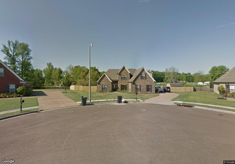
235 Doe Creek Trail N Hernando, MS 38632
Estimated Value: $351,000 - $378,920
3
Beds
--
Bath
2,685
Sq Ft
$137/Sq Ft
Est. Value
About This Home
This home is located at 235 Doe Creek Trail N, Hernando, MS 38632 and is currently estimated at $366,730, approximately $136 per square foot. 235 Doe Creek Trail N is a home located in DeSoto County with nearby schools including Oak Grove Central Elementary School, Hernando Elementary School, and Hernando Hills Elementary.
Ownership History
Date
Name
Owned For
Owner Type
Purchase Details
Closed on
Oct 15, 2021
Sold by
Mckay Andrew
Bought by
Mckay Andrew and Mckay Kendall
Current Estimated Value
Home Financials for this Owner
Home Financials are based on the most recent Mortgage that was taken out on this home.
Original Mortgage
$209,900
Outstanding Balance
$191,409
Interest Rate
2.8%
Mortgage Type
New Conventional
Estimated Equity
$175,321
Purchase Details
Closed on
Sep 21, 2017
Sold by
Edgar Martha and Edgar Jerry
Bought by
Mckay Andrew
Purchase Details
Closed on
Apr 12, 2013
Sold by
Biker Boy Llc
Bought by
Morton Benjamin Vince and Morton Nichole Marie
Home Financials for this Owner
Home Financials are based on the most recent Mortgage that was taken out on this home.
Original Mortgage
$204,415
Interest Rate
3.25%
Mortgage Type
FHA
Create a Home Valuation Report for This Property
The Home Valuation Report is an in-depth analysis detailing your home's value as well as a comparison with similar homes in the area
Home Values in the Area
Average Home Value in this Area
Purchase History
| Date | Buyer | Sale Price | Title Company |
|---|---|---|---|
| Mckay Andrew | -- | Guardian Title Llc | |
| Mckay Andrew | -- | -- | |
| Morton Benjamin Vince | -- | Realty Title |
Source: Public Records
Mortgage History
| Date | Status | Borrower | Loan Amount |
|---|---|---|---|
| Open | Mckay Andrew | $209,900 | |
| Previous Owner | Morton Benjamin Vince | $204,415 |
Source: Public Records
Tax History Compared to Growth
Tax History
| Year | Tax Paid | Tax Assessment Tax Assessment Total Assessment is a certain percentage of the fair market value that is determined by local assessors to be the total taxable value of land and additions on the property. | Land | Improvement |
|---|---|---|---|---|
| 2024 | $2,477 | $20,019 | $3,500 | $16,519 |
| 2023 | $2,477 | $20,019 | $0 | $0 |
| 2022 | $2,477 | $20,019 | $3,500 | $16,519 |
| 2021 | $2,477 | $20,019 | $3,500 | $16,519 |
| 2020 | $2,294 | $18,697 | $0 | $0 |
| 2019 | $2,294 | $18,697 | $3,500 | $15,197 |
| 2017 | $2,257 | $33,172 | $18,336 | $14,836 |
| 2016 | $2,450 | $18,336 | $3,500 | $14,836 |
| 2015 | $2,450 | $33,172 | $18,336 | $14,836 |
| 2014 | $2,092 | $18,336 | $0 | $0 |
| 2013 | $685 | $3,938 | $0 | $0 |
Source: Public Records
Map
Nearby Homes
- 617 Doe Creek Trail N
- 5157 U S 51
- 5153 U S 51
- 5163 U S 51
- 5135 U S 51
- 5147 U S 51
- 5167 U S 51
- 5093 U S 51
- 430 Natchez Loop
- 0 S Old Hwy 51 Unit 4105246
- 566 Shadow View Dr E
- 732 Shadow View Dr
- 994 Deer Creek Dr
- 470 Beacon Hill Dr
- 1064 Tara Dr
- 1094 Peggy Cove
- 0 Highway 51 N
- 208 Elkwood Ln
- 1265 U S 51
- 193 Crockett Loop E
- 235 Doe Creek Trail N
- 44 Doe Creek Trail
- 215 Doe Creek Trail N
- 673 Doe Creek Trail N
- 657 Doe Creek Trail N
- 199 Doe Creek Trail N
- 702 Highway 51 S
- 750 Highway 51 S
- 216 Shady Lane Cove W
- 658 Doe Creek Trail N
- 220 Shady Lane Cove W
- 198 Shady Lane Cove W
- 235 Doe Creek Trail
- 678 Highway 51 S
- 179 Doe Creek Trail N
- 639 Doe Creek Trail N
- 638 Doe Creek Trail N
- 653 Fallbrook Cove
- 653 Fall Brook Cove
- 225 Shady Lane Cove W