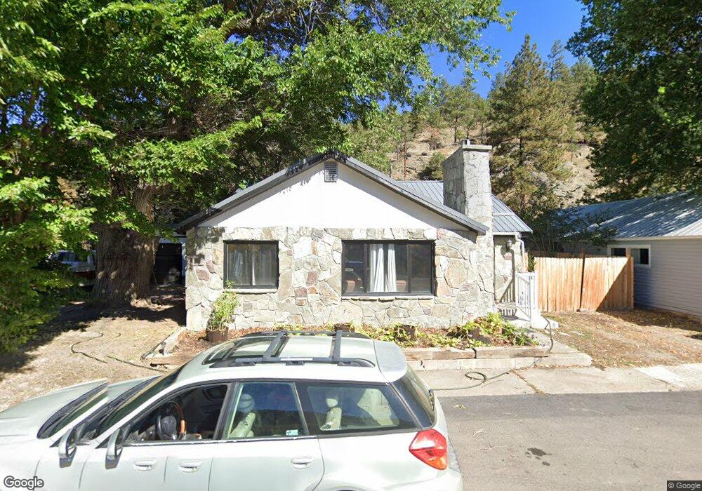
235 Frank Dr Wolf Creek, MT 59648
Estimated Value: $227,000 - $510,000
2
Beds
1
Bath
864
Sq Ft
$475/Sq Ft
Est. Value
About This Home
This home is located at 235 Frank Dr, Wolf Creek, MT 59648 and is currently estimated at $410,774, approximately $475 per square foot. 235 Frank Dr is a home located in Lewis and Clark County.
Ownership History
Date
Name
Owned For
Owner Type
Purchase Details
Closed on
Jan 15, 2025
Sold by
William And Kathleen Gilmore Trust and Robinette William R
Bought by
Lucky Strike Lodge Llc
Current Estimated Value
Purchase Details
Closed on
Jul 19, 2021
Sold by
Craig County Water And Sewer District
Bought by
Gilmore William L and Gilmore Kathleen F
Purchase Details
Closed on
Oct 8, 2008
Sold by
Gilmoe William I
Bought by
Gilmore William I and Gilmore Kathleen F
Create a Home Valuation Report for This Property
The Home Valuation Report is an in-depth analysis detailing your home's value as well as a comparison with similar homes in the area
Home Values in the Area
Average Home Value in this Area
Purchase History
| Date | Buyer | Sale Price | Title Company |
|---|---|---|---|
| Lucky Strike Lodge Llc | -- | Flying S Title & Escrow | |
| Lucky Strike Lodge Llc | -- | Flying S Title & Escrow | |
| Gilmore William L | -- | Helena Abstract & Title Co | |
| Gilmore William I | -- | None Available |
Source: Public Records
Tax History Compared to Growth
Tax History
| Year | Tax Paid | Tax Assessment Tax Assessment Total Assessment is a certain percentage of the fair market value that is determined by local assessors to be the total taxable value of land and additions on the property. | Land | Improvement |
|---|---|---|---|---|
| 2025 | $1,685 | $497,100 | $0 | $0 |
| 2024 | $1,983 | $352,600 | $0 | $0 |
| 2023 | $2,040 | $352,600 | $0 | $0 |
| 2022 | $1,656 | $235,300 | $0 | $0 |
| 2021 | $1,500 | $232,500 | $0 | $0 |
| 2020 | $1,506 | $213,500 | $0 | $0 |
| 2019 | $1,533 | $213,500 | $0 | $0 |
| 2018 | $1,329 | $182,581 | $0 | $0 |
| 2017 | $1,863 | $297,581 | $0 | $0 |
| 2016 | $1,297 | $188,153 | $0 | $0 |
| 2015 | $1,193 | $188,153 | $0 | $0 |
| 2014 | $1,731 | $146,568 | $0 | $0 |
Source: Public Records
Map
Nearby Homes
- 220 Leonard St
- 2755 Sevenmile Rd
- 2155 Craig River Rd Unit 2 Parcels of land
- 4234 & 4236 Marshall Ln
- Tbd Powerline Rd
- 64 Bluebird Dr
- TBD Golden Eagle Dr
- 1348 Beartooth Rd
- 0 Mountain Home Ln Unit 16921312
- 558 Dearborn River Rd
- 68 River Dr
- 2660 Olywood Ct
- Tbd Mountain Home Ln
- Nhn Gunsight Ln Unit Cascade MT 59421
- 23 River Dr
- 153 Cooper Dr
- 41 Sugarloaf Mountain Ln Unit Parcel 2
- 0 Tbd Ridge Crest Ln
- 84 Sugarloaf Mountain Ln
- 2973 Old Us Highway 91
- 225 Frank Dr
- 245 Frank Dr
- 219 Frank Rd
- 255 Frank Dr
- 215 Frank Dr
- 265 Frank Dr
- 295 Frank Dr
- 210 Craig Main St
- 198 Craig Main St
- 215 Leonard St
- 180 Craig Main St
- 191&199 Leonard St
- 170 Craig Main St
- 191 Leonard St
- 160 Craig Main St
- 2728 Craig River Rd
- 130 Craig Main St
- 140 Craig Main St
- 170 Leonard St
- 2720 Craig River Rd