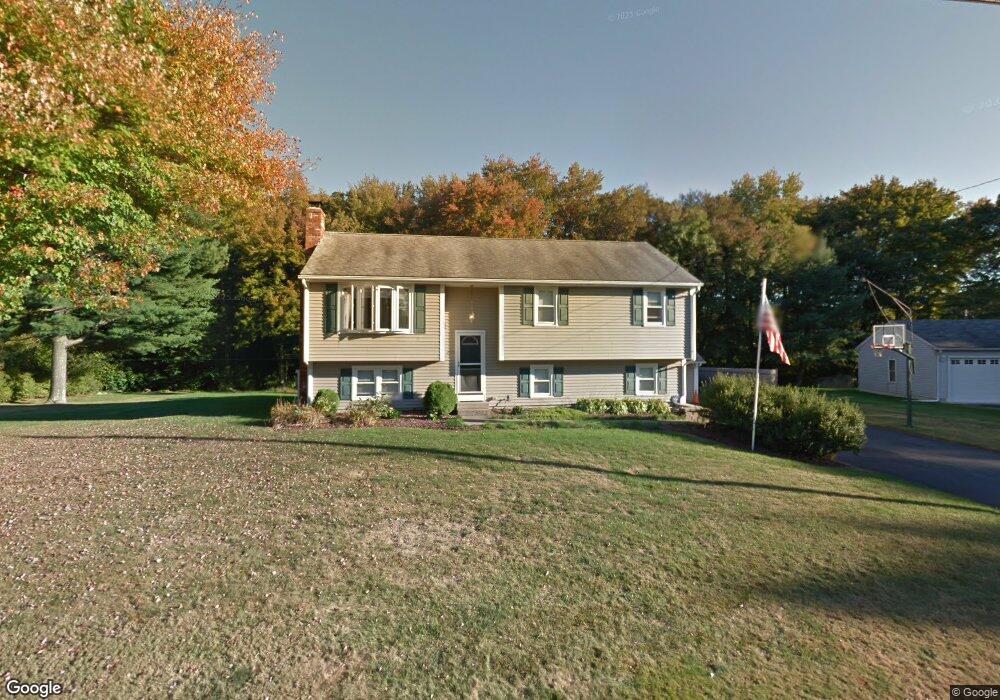
235 Mckeon Dr North Attleboro, MA 02760
North Attleboro NeighborhoodEstimated Value: $546,000 - $628,000
3
Beds
2
Baths
1,132
Sq Ft
$522/Sq Ft
Est. Value
About This Home
This home is located at 235 Mckeon Dr, North Attleboro, MA 02760 and is currently estimated at $591,011, approximately $522 per square foot. 235 Mckeon Dr is a home located in Bristol County with nearby schools including North Attleboro High School, Cadence Academy Preschool - North Attleborough, and St John The Evangelist School.
Ownership History
Date
Name
Owned For
Owner Type
Purchase Details
Closed on
Jul 2, 2024
Sold by
Dieterle Barbara M and Dieterle Scott P
Bought by
2024 Dieterle Ft and Dieterle
Current Estimated Value
Purchase Details
Closed on
May 3, 1999
Sold by
Mclaughlin Diane R
Bought by
Dieterle Scott P and Dieterle Barbara M
Create a Home Valuation Report for This Property
The Home Valuation Report is an in-depth analysis detailing your home's value as well as a comparison with similar homes in the area
Home Values in the Area
Average Home Value in this Area
Purchase History
| Date | Buyer | Sale Price | Title Company |
|---|---|---|---|
| 2024 Dieterle Ft | -- | None Available | |
| 2024 Dieterle Ft | -- | None Available | |
| Dieterle Scott P | $167,900 | -- | |
| Dieterle Scott P | $167,900 | -- |
Source: Public Records
Mortgage History
| Date | Status | Borrower | Loan Amount |
|---|---|---|---|
| Previous Owner | Dieterle Scott P | $259,000 | |
| Previous Owner | Dieterle Scott P | $184,500 |
Source: Public Records
Tax History Compared to Growth
Tax History
| Year | Tax Paid | Tax Assessment Tax Assessment Total Assessment is a certain percentage of the fair market value that is determined by local assessors to be the total taxable value of land and additions on the property. | Land | Improvement |
|---|---|---|---|---|
| 2025 | $5,825 | $494,100 | $151,100 | $343,000 |
| 2024 | $5,566 | $482,300 | $151,100 | $331,200 |
| 2023 | $5,656 | $442,200 | $151,100 | $291,100 |
| 2022 | $5,449 | $391,200 | $151,100 | $240,100 |
| 2021 | $5,197 | $364,200 | $151,100 | $213,100 |
| 2020 | $5,060 | $352,600 | $151,100 | $201,500 |
| 2019 | $4,862 | $341,400 | $137,400 | $204,000 |
| 2018 | $4,329 | $324,500 | $137,400 | $187,100 |
| 2017 | $4,134 | $312,700 | $137,400 | $175,300 |
| 2016 | $4,025 | $304,500 | $152,700 | $151,800 |
| 2015 | $3,757 | $285,900 | $152,700 | $133,200 |
| 2014 | $3,540 | $267,400 | $134,000 | $133,400 |
Source: Public Records
Map
Nearby Homes
- 6 Colts Way
- 122 Mary Ann Way
- 36 Cranberry Rd
- 17 Peters Way
- 47 Old Farm Rd
- 451R Gilbert St
- 115 Westfield Dr
- 6 Cedar Creek Dr
- 14 Claire Ave
- 21 Shady Ln
- 11 Landry Ave
- 20 Sperry Ln
- 176 Elm St
- 10 Sleepy Hollow Cir
- 2 Oak St Unit 2D
- 2 Oak St Unit 2A
- 2 Oak St Unit 2C
- 2 Oak St Unit 2B
- 70 Sperry Ln Unit Lot 11
- 57 Vine St