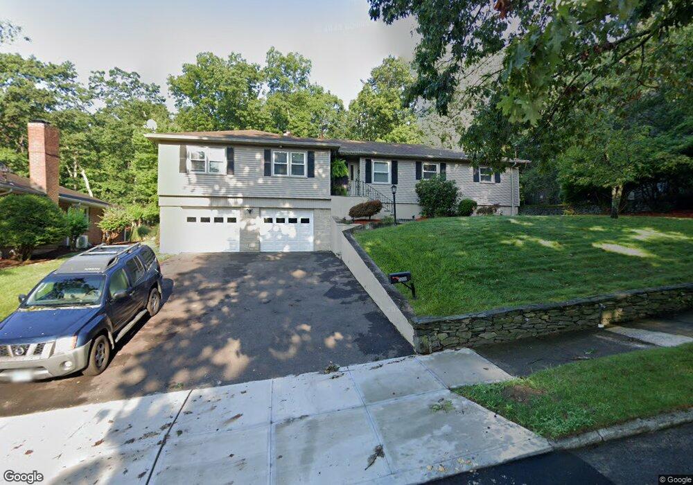
235 Stevenson Rd New Haven, CT 06515
Westville NeighborhoodEstimated Value: $483,125 - $512,000
3
Beds
3
Baths
1,971
Sq Ft
$252/Sq Ft
Est. Value
About This Home
This home is located at 235 Stevenson Rd, New Haven, CT 06515 and is currently estimated at $496,531, approximately $251 per square foot. 235 Stevenson Rd is a home located in New Haven County with nearby schools including Davis Academy for Arts & Design Innovation, Elm City Montessori School, and Hopkins School.
Ownership History
Date
Name
Owned For
Owner Type
Purchase Details
Closed on
Mar 31, 1998
Sold by
Trachten David and Trachten Stacey
Bought by
Roberts John and Roberts Susie M
Current Estimated Value
Home Financials for this Owner
Home Financials are based on the most recent Mortgage that was taken out on this home.
Original Mortgage
$142,200
Interest Rate
6.96%
Mortgage Type
Unknown
Purchase Details
Closed on
Nov 14, 1990
Sold by
Loukides Louis K
Bought by
Trachten David
Create a Home Valuation Report for This Property
The Home Valuation Report is an in-depth analysis detailing your home's value as well as a comparison with similar homes in the area
Home Values in the Area
Average Home Value in this Area
Purchase History
| Date | Buyer | Sale Price | Title Company |
|---|---|---|---|
| Roberts John | $157,500 | -- | |
| Trachten David | $220,000 | -- |
Source: Public Records
Mortgage History
| Date | Status | Borrower | Loan Amount |
|---|---|---|---|
| Open | Trachten David | $111,000 | |
| Closed | Trachten David | $142,200 | |
| Previous Owner | Trachten David | $156,400 | |
| Previous Owner | Trachten David | $153,700 |
Source: Public Records
Tax History
| Year | Tax Paid | Tax Assessment Tax Assessment Total Assessment is a certain percentage of the fair market value that is determined by local assessors to be the total taxable value of land and additions on the property. | Land | Improvement |
|---|---|---|---|---|
| 2025 | $9,488 | $240,800 | $63,700 | $177,100 |
| 2024 | $9,271 | $240,800 | $63,700 | $177,100 |
| 2023 | $8,958 | $240,800 | $63,700 | $177,100 |
| 2022 | $9,572 | $240,800 | $63,700 | $177,100 |
| 2021 | $8,026 | $182,910 | $41,370 | $141,540 |
| 2020 | $8,026 | $182,910 | $41,370 | $141,540 |
| 2019 | $7,861 | $182,910 | $41,370 | $141,540 |
| 2018 | $7,861 | $182,910 | $41,370 | $141,540 |
| 2017 | $7,075 | $182,910 | $41,370 | $141,540 |
| 2016 | $7,178 | $172,760 | $42,980 | $129,780 |
| 2015 | $7,178 | $172,760 | $42,980 | $129,780 |
| 2014 | $7,178 | $172,760 | $42,980 | $129,780 |
Source: Public Records
Map
Nearby Homes
- 690 Forest Rd Unit 702
- 690 Forest Rd Unit 761
- 690 Forest Rd Unit 501
- 690 Forest Rd Unit 651
- 224 Ray Rd
- 56 Roger Rd
- 21 Richmond Ave
- 125 Lowin Ave
- 51 Fountain Terrace
- 119 Westwood Rd
- 55 Marvel Rd
- 252 Alden Ave
- 420 Central Ave
- 50 Morris Ave
- 143 Fountain St Unit A11
- 107 Glen View Terrace
- 1016 Whalley Ave Unit 6
- 595 Central Ave
- 50 Maltby Ave
- 34 Maltby Ave
- 225 Stevenson Rd
- 245 Stevenson Rd
- 240 Stevenson Rd
- 230 Stevenson Rd
- 215 Stevenson Rd
- 257 Stevenson Rd
- 250 Stevenson Rd
- 220 Stevenson Rd
- 205 Stevenson Rd
- 210 Stevenson Rd
- 262 Stevenson Rd
- 271 Stevenson Rd
- 175 Whittier Rd
- 200 Stevenson Rd
- 207 Whittier Rd
- 270 Stevenson Rd
- 220 Whittier Rd
- 161 Whittier Rd
- 180 Whittier Rd
- 190 Stevenson Rd
Your Personal Tour Guide
Ask me questions while you tour the home.