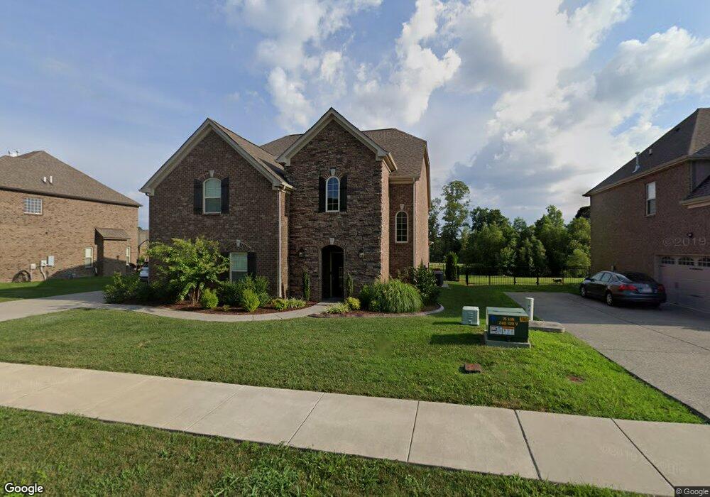
235 Whitestone Ln Gallatin, TN 37066
Estimated Value: $603,451 - $690,000
3
Beds
2
Baths
2,698
Sq Ft
$242/Sq Ft
Est. Value
About This Home
This home is located at 235 Whitestone Ln, Gallatin, TN 37066 and is currently estimated at $653,863, approximately $242 per square foot. 235 Whitestone Ln is a home located in Sumner County with nearby schools including Station Camp High School.
Ownership History
Date
Name
Owned For
Owner Type
Purchase Details
Closed on
Dec 16, 2015
Sold by
Community Development Llc
Bought by
Lewis Stephanie D and Lewis Mark L
Current Estimated Value
Home Financials for this Owner
Home Financials are based on the most recent Mortgage that was taken out on this home.
Original Mortgage
$222,336
Outstanding Balance
$176,472
Interest Rate
3.98%
Mortgage Type
New Conventional
Estimated Equity
$477,391
Purchase Details
Closed on
Jul 15, 2015
Sold by
Green Trails Llc
Bought by
Community Development Llc
Create a Home Valuation Report for This Property
The Home Valuation Report is an in-depth analysis detailing your home's value as well as a comparison with similar homes in the area
Home Values in the Area
Average Home Value in this Area
Purchase History
| Date | Buyer | Sale Price | Title Company |
|---|---|---|---|
| Lewis Stephanie D | $342,336 | Attorney | |
| Community Development Llc | $174,060 | None Available |
Source: Public Records
Mortgage History
| Date | Status | Borrower | Loan Amount |
|---|---|---|---|
| Open | Lewis Stephanie D | $222,336 |
Source: Public Records
Tax History Compared to Growth
Tax History
| Year | Tax Paid | Tax Assessment Tax Assessment Total Assessment is a certain percentage of the fair market value that is determined by local assessors to be the total taxable value of land and additions on the property. | Land | Improvement |
|---|---|---|---|---|
| 2024 | $1,996 | $140,475 | $22,500 | $117,975 |
| 2023 | $3,037 | $99,500 | $12,000 | $87,500 |
| 2022 | $3,047 | $99,500 | $12,000 | $87,500 |
| 2021 | $3,047 | $99,500 | $12,000 | $87,500 |
| 2020 | $3,047 | $99,500 | $12,000 | $87,500 |
| 2019 | $3,017 | $0 | $0 | $0 |
| 2018 | $3,004 | $0 | $0 | $0 |
| 2017 | $3,004 | $0 | $0 | $0 |
| 2016 | $2,152 | $0 | $0 | $0 |
| 2015 | -- | $0 | $0 | $0 |
Source: Public Records
Map
Nearby Homes
- 337 Carellton Dr
- 137 Cavalcade Loop
- 319 Cloverbrook Way
- 101 Santa Rosa Dr
- 360 Turfway Park
- 172 Cavalcade Loop
- 308 Cheval Dr
- 70 Grindstone Dr
- 315 Gulfstream Dr
- 249 Cavalcade Loop
- 427 Deveron Dr
- 1670 Long Hollow Pike
- 2039 Liberty Ln
- 1616 Long Hollow Pike
- 149 Upper Station Camp Crk Rd
- 402 Upper Station Camp Crk Rd
- 1935 Liberty Ln
- 1087 Abberley Cir
- 1080 Abberley Cir
- 166 Jennings Rd
- 235 Whitestone Ln Unit 85
- 235 Whitestone Ln
- 235 Whitestone Ln
- 231 Whitestone Ln
- 231 Whitestone Ln
- 239 Whitestone Ln
- 239 Whitestone Ln
- 238 Whitestone Ln Unit 97
- 238 Whitestone Ln
- 238 Whitestone Ln
- 227 Whitestone Ln
- 227 Whitestone Ln
- 243 Whitestone Ln
- 223 Calumet Ct Unit 72
- 223 Calumet Ct
- 223 Calumet Ct
- 234 Whitestone Ln Unit 96
- 234 Whitestone Ln
- 230 Whitestone Ln Unit 95
- 230 Whitestone Ln