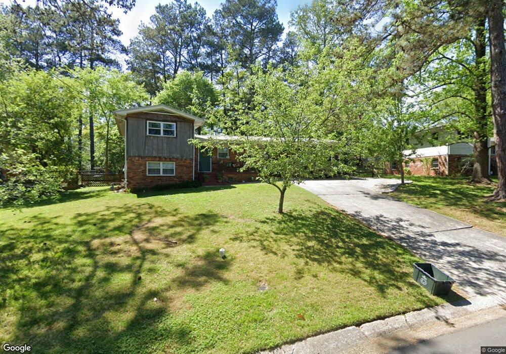
236 Normandy Dr SW Marietta, GA 30064
Southwestern Marietta NeighborhoodEstimated Value: $337,000 - $412,000
4
Beds
2
Baths
924
Sq Ft
$410/Sq Ft
Est. Value
About This Home
This home is located at 236 Normandy Dr SW, Marietta, GA 30064 and is currently estimated at $378,897, approximately $410 per square foot. 236 Normandy Dr SW is a home located in Cobb County with nearby schools including A.L. Burruss Elementary School, Marietta Sixth Grade Academy, and Marietta Middle School.
Ownership History
Date
Name
Owned For
Owner Type
Purchase Details
Closed on
Dec 18, 2000
Sold by
Gould Albert L
Bought by
Grigenas Martynas J
Current Estimated Value
Home Financials for this Owner
Home Financials are based on the most recent Mortgage that was taken out on this home.
Original Mortgage
$117,035
Outstanding Balance
$47,829
Interest Rate
7.75%
Mortgage Type
FHA
Estimated Equity
$331,068
Create a Home Valuation Report for This Property
The Home Valuation Report is an in-depth analysis detailing your home's value as well as a comparison with similar homes in the area
Home Values in the Area
Average Home Value in this Area
Purchase History
| Date | Buyer | Sale Price | Title Company |
|---|---|---|---|
| Grigenas Martynas J | $118,000 | -- |
Source: Public Records
Mortgage History
| Date | Status | Borrower | Loan Amount |
|---|---|---|---|
| Open | Grigenas Martynas J | $117,035 |
Source: Public Records
Tax History Compared to Growth
Tax History
| Year | Tax Paid | Tax Assessment Tax Assessment Total Assessment is a certain percentage of the fair market value that is determined by local assessors to be the total taxable value of land and additions on the property. | Land | Improvement |
|---|---|---|---|---|
| 2025 | $369 | $128,176 | $70,000 | $58,176 |
| 2024 | $369 | $128,176 | $70,000 | $58,176 |
| 2023 | $217 | $146,168 | $70,000 | $76,168 |
| 2022 | $369 | $121,360 | $38,000 | $83,360 |
| 2021 | $381 | $85,348 | $38,000 | $47,348 |
| 2020 | $381 | $85,348 | $38,000 | $47,348 |
| 2019 | $380 | $79,536 | $36,000 | $43,536 |
| 2018 | $380 | $79,536 | $36,000 | $43,536 |
| 2017 | $305 | $72,280 | $22,000 | $50,280 |
| 2016 | $304 | $58,876 | $22,000 | $36,876 |
| 2015 | $333 | $58,876 | $22,000 | $36,876 |
| 2014 | $335 | $52,668 | $0 | $0 |
Source: Public Records
Map
Nearby Homes
- 199 Brookwood Dr SW
- 305 Brookwood Dr SW
- 32 Durham St SW
- 80 Lindley Ave NW Unit 1
- 798 Sentinel Ridge SW
- 873 Cavalry Dr SW
- 260 Manning Rd SW Unit 110
- 838 Cannon Run SW
- 834 Cannon Run SW
- 916 Cannongate Crossing SW Unit 916
- 916 Cannon Gate Crossing
- 1017 Cannongate Crossing SW
- 1011 Cannongate Crossing SW
- 1121 Cannongate Crossing SW
- 325 Polk St NW
- 73 Whitlock Square SW
- 920 Wemberley Ln
- 746 Polk St NW
- 222 Normandy Dr SW
- 246 Normandy Dr SW
- 237 Kirkpatrick Dr SW
- 229 Kirkpatrick Dr SW
- 243 Normandy Dr SW
- 256 Normandy Dr SW
- 211 Kirkpatrick Dr SW
- 247 Kirkpatrick Dr SW
- 227 Normandy Dr SW
- 259 Normandy Dr SW
- 257 Kirkpatrick Dr SW
- 215 Normandy Dr SW Unit 250
- 215 Normandy Dr SW
- 202 Normandy Dr SW
- 205 Kirkpatrick Dr SW
- 0 Kirkpatrick Dr SW Unit 7494977
- 0 Kirkpatrick Dr SW Unit 7289390
- 0 Kirkpatrick Dr SW Unit 8778841
- 0 Kirkpatrick Dr SW Unit 8556739
- 0 Kirkpatrick Dr SW Unit 8251241