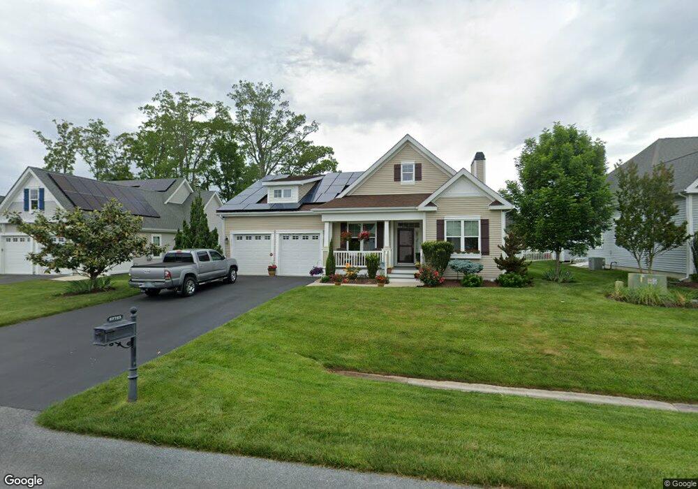
23723 Samuel Adams Cir Millsboro, DE 19966
Harbeson NeighborhoodEstimated Value: $511,327 - $691,000
3
Beds
--
Bath
2,154
Sq Ft
$262/Sq Ft
Est. Value
About This Home
This home is located at 23723 Samuel Adams Cir, Millsboro, DE 19966 and is currently estimated at $564,832, approximately $262 per square foot. 23723 Samuel Adams Cir is a home with nearby schools including Love Creek Elementary School, Mariner Middle School, and Cape Henlopen High School.
Ownership History
Date
Name
Owned For
Owner Type
Purchase Details
Closed on
Jul 1, 2025
Sold by
Patrick Anthony G and Patrick Partick Joanne
Bought by
Anthony Patrick Jr And Joanne Patrick Trust
Current Estimated Value
Purchase Details
Closed on
Dec 22, 2011
Bought by
Patrick Anthony G and Patrick Joanne
Home Financials for this Owner
Home Financials are based on the most recent Mortgage that was taken out on this home.
Original Mortgage
$140,000
Interest Rate
3.98%
Purchase Details
Closed on
Dec 21, 2011
Bought by
Patrick Anthony G and Patrick Joanne
Home Financials for this Owner
Home Financials are based on the most recent Mortgage that was taken out on this home.
Original Mortgage
$140,000
Interest Rate
3.98%
Create a Home Valuation Report for This Property
The Home Valuation Report is an in-depth analysis detailing your home's value as well as a comparison with similar homes in the area
Home Values in the Area
Average Home Value in this Area
Purchase History
| Date | Buyer | Sale Price | Title Company |
|---|---|---|---|
| Anthony Patrick Jr And Joanne Patrick Trust | -- | None Listed On Document | |
| Anthony Patrick Jr And Joanne Patrick Trust | -- | None Listed On Document | |
| Patrick Anthony G | $343,851 | -- | |
| Patrick Anthony G | $343,851 | -- |
Source: Public Records
Mortgage History
| Date | Status | Borrower | Loan Amount |
|---|---|---|---|
| Previous Owner | Patrick Anthony G | $140,000 | |
| Previous Owner | Patrick Anthony G | $140,000 |
Source: Public Records
Tax History Compared to Growth
Tax History
| Year | Tax Paid | Tax Assessment Tax Assessment Total Assessment is a certain percentage of the fair market value that is determined by local assessors to be the total taxable value of land and additions on the property. | Land | Improvement |
|---|---|---|---|---|
| 2025 | $663 | $31,350 | $5,000 | $26,350 |
| 2024 | $1,045 | $31,350 | $5,000 | $26,350 |
| 2023 | $1,044 | $31,350 | $5,000 | $26,350 |
| 2022 | $990 | $31,350 | $5,000 | $26,350 |
| 2021 | $1,076 | $31,350 | $5,000 | $26,350 |
| 2020 | $1,072 | $31,350 | $5,000 | $26,350 |
| 2019 | $1,074 | $31,350 | $5,000 | $26,350 |
| 2018 | $977 | $31,350 | $0 | $0 |
| 2017 | $918 | $31,350 | $0 | $0 |
| 2016 | $1,252 | $31,350 | $0 | $0 |
| 2015 | $1,197 | $31,350 | $0 | $0 |
| 2014 | $1,188 | $31,350 | $0 | $0 |
Source: Public Records
Map
Nearby Homes
- 29738 Oliver Wolcott Dr
- 29432 Andrew Jackson Dr
- 23862 Samuel Adams Cir
- 23792 Samuel Adams Cir
- 24006 Benjamin Harrison Cir
- 29688 Patrick Henry Cir
- 24877 Stevenson Rd
- TBB Scarough Ln Unit ANTIGUA
- 2 Falcon Crest Dr
- 24692 Michael Isler Ave
- 24700 Michael Isler Ave
- 24735 Ridgeville Way
- 24711 Ridgeville Way
- Latitude Plan at Wetherby
- Barbados Plan at Wetherby
- St. Kitts Plan at Wetherby
- Antigua Plan at Wetherby
- Aloha Plan at Wetherby
- Dune Plan at Wetherby
- TBB Michael Isler Dr Unit BARBADOS
- 23719 Samuel Adams Cir
- 23727 Samuel Adams Cir
- 29680 Franklin Roosevelt Ln
- 29684 Franklin Roosevelt Ln
- 23729 Samuel Adams Cir
- 23717 Samuel Adams Cir
- 29676 Franklin Roosevelt Ln
- 23724 Samuel Adams Cir
- 29688 Franklin Roosevelt Ln
- 23720 Samuel Adams Cir
- 23728 Samuel Adams Cir
- 29674 Franklin Roosevelt Ln
- 23718 Samuel Adams Cir
- 23713 Samuel Adams Cir
- 23733 Samuel Adams Cir
- 23730 Samuel Adams Cir
- 29690 Franklin Roosevelt Ln
- 23714 Samuel Adams Cir
- 29670 Franklin Roosevelt Ln
- 29681 Franklin Roosevelt Ln