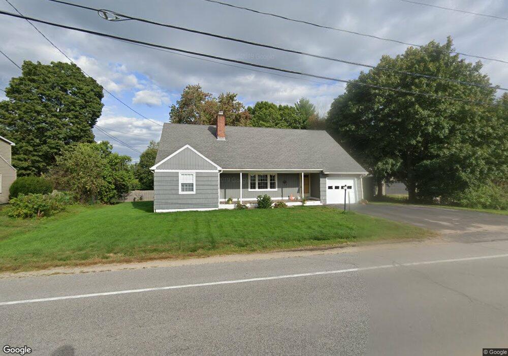
238 Dover Point Rd Dover, NH 03820
Dover Point NeighborhoodEstimated Value: $557,000 - $753,000
3
Beds
2
Baths
1,832
Sq Ft
$342/Sq Ft
Est. Value
About This Home
This home is located at 238 Dover Point Rd, Dover, NH 03820 and is currently estimated at $626,862, approximately $342 per square foot. 238 Dover Point Rd is a home located in Strafford County with nearby schools including Garrison School, Dover Middle School, and Dover Senior High School.
Ownership History
Date
Name
Owned For
Owner Type
Purchase Details
Closed on
Mar 20, 2024
Sold by
Cooley Diane L
Bought by
Diane L Cooley Ret and Cooley
Current Estimated Value
Purchase Details
Closed on
Jan 6, 2009
Sold by
Allen Ft
Bought by
Cooley Diane L
Home Financials for this Owner
Home Financials are based on the most recent Mortgage that was taken out on this home.
Original Mortgage
$208,867
Interest Rate
6.08%
Mortgage Type
Purchase Money Mortgage
Create a Home Valuation Report for This Property
The Home Valuation Report is an in-depth analysis detailing your home's value as well as a comparison with similar homes in the area
Home Values in the Area
Average Home Value in this Area
Purchase History
| Date | Buyer | Sale Price | Title Company |
|---|---|---|---|
| Diane L Cooley Ret | -- | None Available | |
| Diane L Cooley Ret | -- | None Available | |
| Cooley Diane L | $210,000 | -- |
Source: Public Records
Mortgage History
| Date | Status | Borrower | Loan Amount |
|---|---|---|---|
| Previous Owner | Cooley Diane L | $198,514 | |
| Previous Owner | Cooley Diane L | $208,867 |
Source: Public Records
Tax History
| Year | Tax Paid | Tax Assessment Tax Assessment Total Assessment is a certain percentage of the fair market value that is determined by local assessors to be the total taxable value of land and additions on the property. | Land | Improvement |
|---|---|---|---|---|
| 2024 | $9,292 | $511,400 | $158,200 | $353,200 |
| 2023 | $8,295 | $443,600 | $139,800 | $303,800 |
| 2022 | $8,319 | $419,300 | $139,800 | $279,500 |
| 2021 | $7,823 | $360,500 | $117,800 | $242,700 |
| 2020 | $7,872 | $316,800 | $117,800 | $199,000 |
| 2019 | $7,597 | $301,600 | $106,700 | $194,900 |
| 2018 | $6,945 | $278,700 | $95,700 | $183,000 |
| 2017 | $6,693 | $258,700 | $81,000 | $177,700 |
| 2016 | $6,270 | $238,500 | $76,900 | $161,600 |
| 2015 | $5,937 | $223,100 | $65,400 | $157,700 |
| 2014 | $5,803 | $223,100 | $65,400 | $157,700 |
| 2011 | $5,273 | $209,900 | $69,000 | $140,900 |
Source: Public Records
Map
Nearby Homes
- Slip B18 Little Bay
- 25 Fosters Dr
- 708 River Rd Unit 2
- 708 River Rd Unit 3
- 18 Deborah Ln
- 41 Clearwater Dr
- 0 Cote Dr Unit 55B
- 348 Dover Point Rd
- 354 Dover Point Rd
- 1708 State Rd
- 69 Polly Ann Trailer Park
- 18 Little Bay Dr
- 16 Polly Ann Park
- 19 Lenox Dr Unit A
- 1 Greenfield Dr
- Lot 2 Cedar Tbd
- 10 Pasture Hill Dr
- 6 Isaac Lucas Cir
- 6 Revolution Dr
- 4 Freedom Dr
- 236 Dover Point Rd
- 1 Roberts Rd
- 240 Dover Point Rd
- 235 Dover Point Rd
- 23 Roberts Rd
- 3 Roberts Rd
- 237 Dover Point Rd
- 232 Dover Point Rd
- 239 Dover Point Rd
- 233 Dover Point Rd
- 241 Dover Point Rd
- 242 Dover Point Rd
- 21 Roberts Rd
- 24 Roberts Rd
- 7 Roberts Rd
- 4 Roberts Rd
- 5 Roberts Rd
- 22 Roberts Rd
- 230 Dover Point Rd
- 243 Dover Point Rd
Your Personal Tour Guide
Ask me questions while you tour the home.