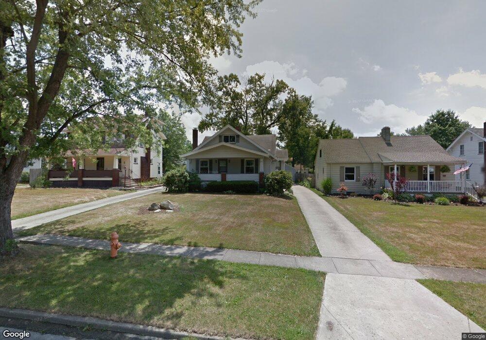
239 Erskine Ave Youngstown, OH 44512
Estimated Value: $140,168 - $167,000
3
Beds
2
Baths
1,546
Sq Ft
$101/Sq Ft
Est. Value
About This Home
This home is located at 239 Erskine Ave, Youngstown, OH 44512 and is currently estimated at $156,542, approximately $101 per square foot. 239 Erskine Ave is a home located in Mahoning County with nearby schools including Boardman Glenwood Junior High School, Boardman High School, and Horizon Science Academy - Youngstown.
Ownership History
Date
Name
Owned For
Owner Type
Purchase Details
Closed on
Oct 28, 2009
Sold by
Sandine Dominic and Sandine Margaret R
Bought by
Devore Steven and Devore Amanda
Current Estimated Value
Purchase Details
Closed on
Dec 6, 1999
Sold by
Borosky Paul R and Borosky Maureen
Bought by
Sandine Dominic
Purchase Details
Closed on
Mar 29, 1989
Bought by
Borosky Paul R
Create a Home Valuation Report for This Property
The Home Valuation Report is an in-depth analysis detailing your home's value as well as a comparison with similar homes in the area
Home Values in the Area
Average Home Value in this Area
Purchase History
| Date | Buyer | Sale Price | Title Company |
|---|---|---|---|
| Devore Steven | $40,000 | Attorney | |
| Sandine Dominic | $66,500 | -- | |
| Borosky Paul R | $47,900 | -- |
Source: Public Records
Tax History Compared to Growth
Tax History
| Year | Tax Paid | Tax Assessment Tax Assessment Total Assessment is a certain percentage of the fair market value that is determined by local assessors to be the total taxable value of land and additions on the property. | Land | Improvement |
|---|---|---|---|---|
| 2024 | $1,873 | $36,390 | $4,180 | $32,210 |
| 2023 | $1,848 | $36,390 | $4,180 | $32,210 |
| 2022 | $1,503 | $22,490 | $3,860 | $18,630 |
| 2021 | $1,504 | $22,490 | $3,860 | $18,630 |
| 2020 | $1,512 | $22,490 | $3,860 | $18,630 |
| 2019 | $1,482 | $19,220 | $3,300 | $15,920 |
| 2018 | $1,250 | $19,220 | $3,300 | $15,920 |
| 2017 | $1,390 | $19,220 | $3,300 | $15,920 |
| 2016 | $1,547 | $23,960 | $3,690 | $20,270 |
| 2015 | $1,516 | $23,960 | $3,690 | $20,270 |
| 2014 | $1,521 | $23,960 | $3,690 | $20,270 |
| 2013 | $1,502 | $23,960 | $3,690 | $20,270 |
Source: Public Records
Map
Nearby Homes
- 167 Afton Ave
- 149 Argyle Ave
- 127 Melrose Ave
- 0 Mathews Rd Unit 5038026
- 81 Melrose Ave
- 175 Homestead Dr
- 197 Mathews Rd Unit B
- 6001 Applecrest Dr
- 429 Tudor Ln
- 44 Gertrude Ave
- 424 Mathews Rd
- 4715 Euclid Blvd
- 148 Clifton Dr
- 767 Indianola Rd
- 642 Oakridge Dr
- 83 Beechwood Dr
- 4552 New England Blvd
- 732 Forest Ridge Dr
- 28 Terrace Dr
- 94 Beechwood Dr
- 243 Erskine Ave
- 235 Erskine Ave
- 249 Erskine Ave
- 229 Erskine Ave
- 253 Erskine Ave
- 236 Afton Ave
- 225 Erskine Ave
- 242 Afton Ave
- 230 Afton Ave
- 248 Afton Ave
- 226 Afton Ave
- 259 Erskine Ave
- 219 Erskine Ave
- 252 Afton Ave
- 240 Erskine Ave
- 244 Erskine Ave
- 234 Erskine Ave
- 230 Erskine Ave
- 263 Erskine Ave
- 215 Erskine Ave