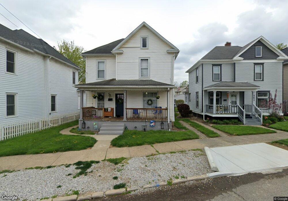
239 N 10th St Newark, OH 43055
Estimated Value: $187,000 - $197,000
3
Beds
1
Bath
1,434
Sq Ft
$134/Sq Ft
Est. Value
About This Home
This home is located at 239 N 10th St, Newark, OH 43055 and is currently estimated at $192,068, approximately $133 per square foot. 239 N 10th St is a home located in Licking County with nearby schools including John Clem Elementary School, Liberty Middle School, and Newark High School.
Ownership History
Date
Name
Owned For
Owner Type
Purchase Details
Closed on
Oct 14, 2022
Sold by
Brooke Sousa Capital Llc
Bought by
Eskins Bri
Current Estimated Value
Home Financials for this Owner
Home Financials are based on the most recent Mortgage that was taken out on this home.
Original Mortgage
$162,011
Outstanding Balance
$155,480
Interest Rate
5.66%
Mortgage Type
FHA
Estimated Equity
$36,588
Purchase Details
Closed on
Nov 22, 2021
Sold by
Sharpe Family Revocable Living Trust
Bought by
Brooke Sousa Capital Llc
Home Financials for this Owner
Home Financials are based on the most recent Mortgage that was taken out on this home.
Original Mortgage
$72,896
Interest Rate
3.56%
Mortgage Type
New Conventional
Create a Home Valuation Report for This Property
The Home Valuation Report is an in-depth analysis detailing your home's value as well as a comparison with similar homes in the area
Home Values in the Area
Average Home Value in this Area
Purchase History
| Date | Buyer | Sale Price | Title Company |
|---|---|---|---|
| Eskins Bri | $165,000 | -- | |
| Brooke Sousa Capital Llc | -- | None Listed On Document |
Source: Public Records
Mortgage History
| Date | Status | Borrower | Loan Amount |
|---|---|---|---|
| Open | Eskins Bri | $162,011 | |
| Previous Owner | Brooke Sousa Capital Llc | $72,896 |
Source: Public Records
Tax History
| Year | Tax Paid | Tax Assessment Tax Assessment Total Assessment is a certain percentage of the fair market value that is determined by local assessors to be the total taxable value of land and additions on the property. | Land | Improvement |
|---|---|---|---|---|
| 2024 | $1,504 | $42,110 | $9,940 | $32,170 |
| 2023 | $1,504 | $42,110 | $9,940 | $32,170 |
| 2022 | $1,202 | $29,160 | $5,600 | $23,560 |
| 2021 | $1,260 | $29,160 | $5,600 | $23,560 |
| 2020 | $1,289 | $29,160 | $5,600 | $23,560 |
| 2019 | $1,047 | $22,790 | $4,660 | $18,130 |
| 2018 | $1,048 | $0 | $0 | $0 |
| 2017 | $1,004 | $0 | $0 | $0 |
| 2016 | $806 | $0 | $0 | $0 |
| 2015 | $823 | $0 | $0 | $0 |
| 2014 | $1,026 | $0 | $0 | $0 |
| 2013 | $825 | $0 | $0 | $0 |
Source: Public Records
Map
Nearby Homes
- 218 Granville St
- 185 N 10th St
- 293 Merchant St
- 207 Buckingham St
- 210 Buckingham St
- 355 Eddy St
- 361 Granville St
- 99 Hoover St
- 385 Woods Ave
- 69 Wallace St
- 122 W Shields St
- 377 Saint James Gate
- 191 Elmwood Ave
- 27 W North St
- 441 Mount Vernon Rd
- 242 Hudson Ave
- 214-218 Hudson Ave
- 12 E Saint Clair St
- 346 W Main St
- 311 Clinton St
Your Personal Tour Guide
Ask me questions while you tour the home.