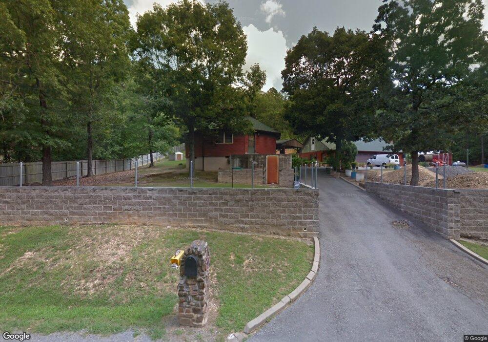
23950 Mashburn Trail Little Rock, AR 72210
Western Little Rock NeighborhoodEstimated Value: $166,000 - $322,000
--
Bed
1
Bath
1,142
Sq Ft
$197/Sq Ft
Est. Value
About This Home
This home is located at 23950 Mashburn Trail, Little Rock, AR 72210 and is currently estimated at $225,244, approximately $197 per square foot. 23950 Mashburn Trail is a home located in Pulaski County with nearby schools including Chenal Elementary School, Joe T. Robinson Middle School, and Joe T. Robinson High School.
Ownership History
Date
Name
Owned For
Owner Type
Purchase Details
Closed on
Jun 7, 2018
Sold by
Burns Billy V and Burns Dolores A
Bought by
Burns Billy V and Burns Dolores A
Current Estimated Value
Purchase Details
Closed on
Dec 16, 2002
Sold by
Valburns Billy and Burns Dolores Ann
Bought by
Burns Billy and Burns Dolores A
Home Financials for this Owner
Home Financials are based on the most recent Mortgage that was taken out on this home.
Original Mortgage
$68,500
Interest Rate
5.96%
Create a Home Valuation Report for This Property
The Home Valuation Report is an in-depth analysis detailing your home's value as well as a comparison with similar homes in the area
Home Values in the Area
Average Home Value in this Area
Purchase History
| Date | Buyer | Sale Price | Title Company |
|---|---|---|---|
| Burns Billy V | -- | None Available | |
| Burns Billy | -- | American Abstract & Title Co |
Source: Public Records
Mortgage History
| Date | Status | Borrower | Loan Amount |
|---|---|---|---|
| Closed | Burns Billy | $68,500 |
Source: Public Records
Tax History Compared to Growth
Tax History
| Year | Tax Paid | Tax Assessment Tax Assessment Total Assessment is a certain percentage of the fair market value that is determined by local assessors to be the total taxable value of land and additions on the property. | Land | Improvement |
|---|---|---|---|---|
| 2025 | $873 | $29,992 | $4,980 | $25,012 |
| 2024 | $1,050 | $29,992 | $4,980 | $25,012 |
| 2023 | $1,050 | $29,992 | $4,980 | $25,012 |
| 2022 | $1,052 | $29,992 | $4,980 | $25,012 |
| 2021 | $1,004 | $18,780 | $4,150 | $14,630 |
| 2020 | $629 | $18,780 | $4,150 | $14,630 |
| 2019 | $629 | $18,780 | $4,150 | $14,630 |
| 2018 | $654 | $18,780 | $4,150 | $14,630 |
| 2017 | $654 | $18,780 | $4,150 | $14,630 |
| 2016 | $938 | $18,460 | $5,810 | $12,650 |
| 2015 | $938 | $18,460 | $5,810 | $12,650 |
| 2014 | $938 | $18,460 | $5,810 | $12,650 |
Source: Public Records
Map
Nearby Homes
- 0 Fox Ridge Rd Unit 25010505
- 211 County Line Rd
- 5 Jabo Lake Rd
- 24923 Colonel Glenn Rd
- 000 Foxridge Rd
- 32315 Kanis Rd
- 25501 Kanis Rd
- 2003 Lambert Rd
- 0 Serenity Dr
- 22125 Colonel Glenn Rd
- 17615 Burlingame Rd
- 20377 Congo Ferndale Rd
- Lot 2 Barry Ln
- Lot 3 Barry Ln
- Lot 1 Barry Ln
- Lot 4 Barry Ln
- 3110 Ferndale Cut Off Rd
- 23201 Barry Ln
- 2301 Beauchamp Rd
- 12433 Raindrop Ln
- 24000 Mashburn Trail
- 23923 Mashburn Trail
- 23847 Mashburn Trail
- 24101 Mashburn Trail
- 23840 Mashburn Trail
- 23850 Mashburn Trail
- 24200 Mashburn Trail
- 000 Mashburn Trail
- 24220 Mashburn Trail
- 24220 Mashburn Trail
- 24221 Mashburn Trail
- 1421 Whispering Pine Rd
- 24301 Mashburn Trail
- 101 Doe Dr
- 0 Mashburn Trail Unit 17032465
- 28340 Mashburn Trail
- 102 Doe Dr
- 100 Doe Dr
- 1420 Whispering Pine Rd