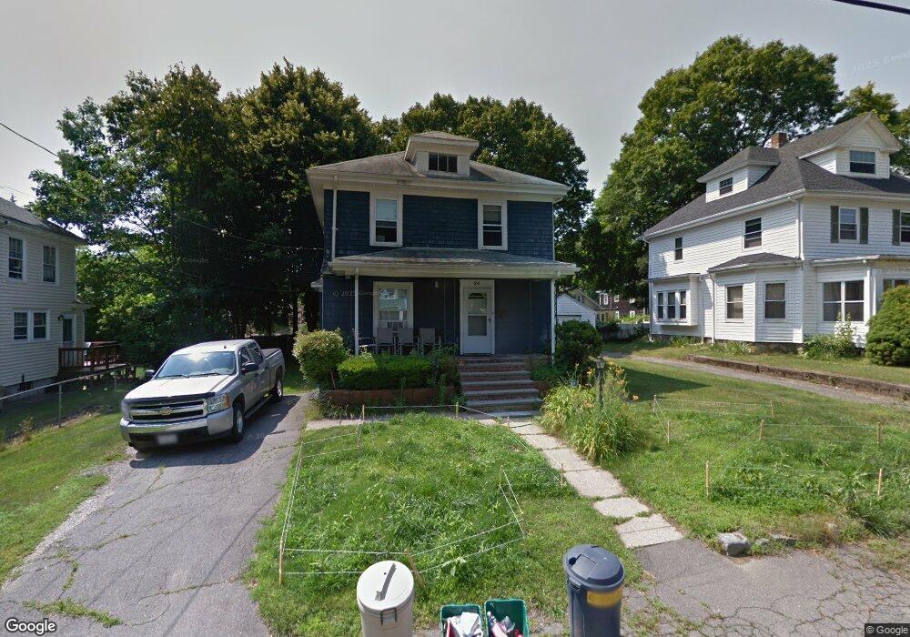
24 Cushing Ave Brockton, MA 02301
Campello NeighborhoodEstimated Value: $454,000 - $470,000
3
Beds
1
Bath
1,196
Sq Ft
$386/Sq Ft
Est. Value
About This Home
This home is located at 24 Cushing Ave, Brockton, MA 02301 and is currently estimated at $461,141, approximately $385 per square foot. 24 Cushing Ave is a home located in Plymouth County with nearby schools including Gilmore Elementary School, Davis K-8 School, and John F. Kennedy Elementary School.
Ownership History
Date
Name
Owned For
Owner Type
Purchase Details
Closed on
Feb 16, 2001
Sold by
Mellman Lee B
Bought by
Langaigne David J
Current Estimated Value
Home Financials for this Owner
Home Financials are based on the most recent Mortgage that was taken out on this home.
Original Mortgage
$137,700
Interest Rate
7.08%
Mortgage Type
Purchase Money Mortgage
Create a Home Valuation Report for This Property
The Home Valuation Report is an in-depth analysis detailing your home's value as well as a comparison with similar homes in the area
Home Values in the Area
Average Home Value in this Area
Purchase History
| Date | Buyer | Sale Price | Title Company |
|---|---|---|---|
| Langaigne David J | $139,000 | -- |
Source: Public Records
Mortgage History
| Date | Status | Borrower | Loan Amount |
|---|---|---|---|
| Open | Langaigne David J | $188,000 | |
| Closed | Langaigne David J | $40,000 | |
| Closed | Langaigne David J | $139,400 | |
| Closed | Langaigne David J | $137,700 |
Source: Public Records
Tax History
| Year | Tax Paid | Tax Assessment Tax Assessment Total Assessment is a certain percentage of the fair market value that is determined by local assessors to be the total taxable value of land and additions on the property. | Land | Improvement |
|---|---|---|---|---|
| 2025 | $4,477 | $369,700 | $139,600 | $230,100 |
| 2024 | $4,309 | $358,500 | $139,600 | $218,900 |
| 2023 | $4,135 | $318,600 | $103,700 | $214,900 |
| 2022 | $4,053 | $290,100 | $94,300 | $195,800 |
| 2021 | $3,887 | $268,100 | $78,200 | $189,900 |
| 2020 | $3,738 | $246,700 | $73,400 | $173,300 |
| 2019 | $3,456 | $222,400 | $71,500 | $150,900 |
| 2018 | $3,422 | $213,100 | $71,500 | $141,600 |
| 2017 | $3,141 | $195,100 | $71,500 | $123,600 |
| 2016 | $2,693 | $155,100 | $69,300 | $85,800 |
| 2015 | $2,641 | $145,500 | $69,300 | $76,200 |
| 2014 | $2,484 | $137,000 | $69,300 | $67,700 |
Source: Public Records
Map
Nearby Homes
- 47 Southworth St
- 35 Longworth Ave Unit 25
- 25 Longworth Ave Unit 4
- 326 Copeland St
- 15 Longworth Ave Unit 226
- 9 Longworth Ave Unit 135
- 9 Longworth Ave Unit 113
- 115 Market St
- 34 South St
- 15 Market St
- 26 South St
- 60 Tremont St
- 65 Tremont St
- 23 E Chestnut St
- 25 Tremont St
- 223 Clinton St Unit 16
- 24 E Chestnut St
- 12 Finny's Way
- 82 Carroll Ave
- 936 Warren Ave
- 26 Cushing Ave
- 20 Cushing Ave
- 129 Brookside Ave
- 32 Cushing Ave
- 123 Brookside Ave
- 16 Cushing Ave
- 131 Brookside Ave
- 23 Cushing Ave
- 115 Brookside Ave
- 36 Cushing Ave
- 137 Brookside Ave
- 11 Cushing Ave
- 4 Cushing Ave
- 141 Brookside Ave
- 71 Grant Ave
- 42 Cushing Ave
- 95 Churchill Ave
- 62 Grant Ave
- 128 Brookside Ave
- 134 Brookside Ave
Your Personal Tour Guide
Ask me questions while you tour the home.