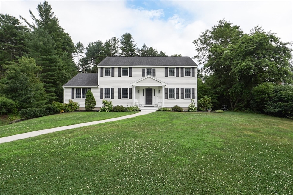
24 Enfield Dr Andover, MA 01810
Estimated payment $8,431/month
Highlights
- Guest House
- Open Floorplan
- Covered Deck
- South Elementary School Rated A
- Colonial Architecture
- Wooded Lot
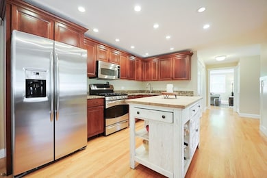
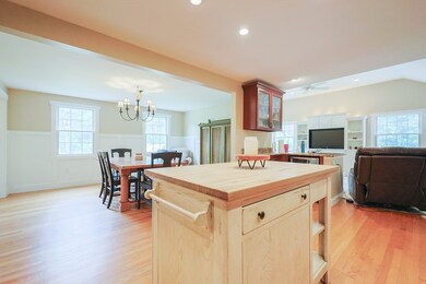
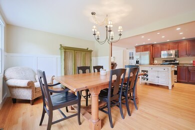
About This Home
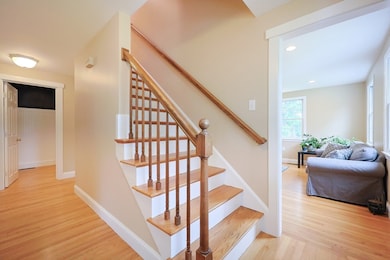
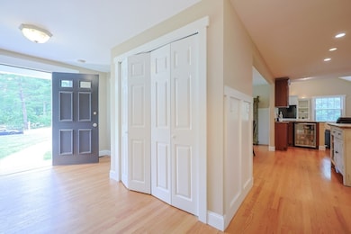
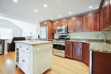
Welcome to this Rare Gem in One of Andover’s Most Coveted Neighborhoods. Set over an acre of beautifully landscaped grounds with scenic views, this exceptional property offers the perfect blend of comfort and versatility. The main residence features 4 bedrooms, 2.5 baths, a 2-car garage, showcasing gleaming hardwood floors throughout, and a sun-filled great room ideal for both everyday living and entertaining. Step outside to enjoy the expansive deck or relax year-round on the enclosed porch, both perfect for taking in the serene surroundings. What truly sets this home apart is the attached private in-law apartment, complete with its own entrance, kitchen, living area, bedroom, bath, and 1-car garage ideal for extended family and guests. Close Proximity to top-rated South School, Phillips Academy, downtown Andover, and scenic trails. Whether you’re looking for multigenerational living or extra flexibility, this unique property delivers space, functionality, and location
Home Details
Home Type
- Single Family
Est. Annual Taxes
- $13,688
Year Built
- Built in 1974 | Remodeled
Lot Details
- 1.18 Acre Lot
- Sprinkler System
- Wooded Lot
- Property is zoned SRC
Parking
- 3 Car Attached Garage
- Driveway
- Open Parking
- Off-Street Parking
Home Design
- Colonial Architecture
- Frame Construction
- Shingle Roof
- Concrete Perimeter Foundation
Interior Spaces
- Open Floorplan
- Wet Bar
- Crown Molding
- Vaulted Ceiling
- Ceiling Fan
- Light Fixtures
- 1 Fireplace
- Insulated Windows
- Picture Window
- Sliding Doors
- Dining Area
- Bonus Room
- Home Security System
Kitchen
- Range
- Dishwasher
- Solid Surface Countertops
- Disposal
Flooring
- Wood
- Ceramic Tile
- Vinyl
Bedrooms and Bathrooms
- 5 Bedrooms
- Primary bedroom located on second floor
- Linen Closet
- In-Law or Guest Suite
- Separate Shower
Laundry
- Laundry on main level
- Laundry in Bathroom
- Dryer
- Washer
Partially Finished Basement
- Walk-Out Basement
- Partial Basement
- Interior Basement Entry
- Garage Access
Outdoor Features
- Balcony
- Covered Deck
- Enclosed Patio or Porch
- Outdoor Storage
- Rain Gutters
Schools
- South Elementary School
- Doherty Middle School
- Andover High School
Utilities
- Central Heating and Cooling System
- 3 Cooling Zones
- 3 Heating Zones
- Heating System Uses Propane
- 200+ Amp Service
- Electric Water Heater
Additional Features
- Guest House
- Property is near schools
Listing and Financial Details
- Assessor Parcel Number M:00120 B:00015 L:00000,1842659
Community Details
Overview
- No Home Owners Association
- Near Conservation Area
Amenities
- Shops
Recreation
- Park
- Jogging Path
Map
Home Values in the Area
Average Home Value in this Area
Tax History
| Year | Tax Paid | Tax Assessment Tax Assessment Total Assessment is a certain percentage of the fair market value that is determined by local assessors to be the total taxable value of land and additions on the property. | Land | Improvement |
|---|---|---|---|---|
| 2024 | $13,688 | $1,062,700 | $539,600 | $523,100 |
| 2023 | $13,115 | $960,100 | $485,900 | $474,200 |
| 2022 | $12,375 | $847,600 | $422,800 | $424,800 |
| 2021 | $11,891 | $777,700 | $384,200 | $393,500 |
| 2020 | $11,447 | $762,600 | $375,000 | $387,600 |
| 2019 | $11,062 | $724,400 | $342,600 | $381,800 |
| 2018 | $10,688 | $683,400 | $329,400 | $354,000 |
| 2017 | $10,272 | $676,700 | $323,000 | $353,700 |
| 2016 | $10,063 | $679,000 | $323,000 | $356,000 |
| 2015 | $9,716 | $649,000 | $310,600 | $338,400 |
Property History
| Date | Event | Price | List to Sale | Price per Sq Ft |
|---|---|---|---|---|
| 10/28/2025 10/28/25 | Pending | -- | -- | -- |
| 07/10/2025 07/10/25 | For Sale | $1,390,000 | -- | $363 / Sq Ft |
Purchase History
| Date | Type | Sale Price | Title Company |
|---|---|---|---|
| Leasehold Conv With Agreement Of Sale Fee Purchase Hawaii | $326,000 | -- |
Mortgage History
| Date | Status | Loan Amount | Loan Type |
|---|---|---|---|
| Open | $207,000 | Purchase Money Mortgage |
Source: MLS Property Information Network (MLS PIN)
MLS Number: 73402521
APN: ANDO-000120-000015
Disclaimer: Certain information contained herein is derived from information provided by parties other than Homes.com. All information provided is deemed reliable, but is not guaranteed to be accurate and should be independently verified.
![]() The property listing data and information, or the Images, set forth herein were provided to MLS Property Information Network, Inc. from third party sources, including sellers, lessors and public records, and were compiled by MLS Property Information Network, Inc. The property listing data and information, and the Images, are for the personal, non-commercial use of consumers having a good faith interest in purchasing or leasing listed properties of the type displayed to them and may not be used for any purpose other than to identify prospective properties which such consumers may have a good faith interest in purchasing or leasing. MLS Property Information Network, Inc. and its subscribers disclaim any and all representations and warranties as to the accuracy of the property listing data and information, or as to the accuracy of any of the Images, set forth herein.
The property listing data and information, or the Images, set forth herein were provided to MLS Property Information Network, Inc. from third party sources, including sellers, lessors and public records, and were compiled by MLS Property Information Network, Inc. The property listing data and information, and the Images, are for the personal, non-commercial use of consumers having a good faith interest in purchasing or leasing listed properties of the type displayed to them and may not be used for any purpose other than to identify prospective properties which such consumers may have a good faith interest in purchasing or leasing. MLS Property Information Network, Inc. and its subscribers disclaim any and all representations and warranties as to the accuracy of the property listing data and information, or as to the accuracy of any of the Images, set forth herein.
- 40 Ballardvale Rd
- 3 West Hollow
- 56 Sunset Rock Rd
- 18 Dale St Unit 4G
- 2 Clover Cir
- 25 Timothy Dr
- 18 Boston Rd
- 331 S Main St
- 21 Rocky Hill Rd
- 17 Linda Rd
- 4 Hammond Way
- 50 Hidden Rd
- 31 Porter Rd
- 4 Hazelwood Cir
- 11 Gould Rd
- 33 Dascomb Rd
- 18 Bryan Ln Unit 18
- 9 Flash Rd
- 40 Colonial Dr Unit 8
- 20 Colonial Dr Unit 3
