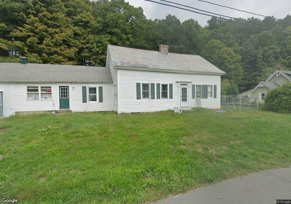
24 Factory Hollow Greenfield, MA 01301
Estimated Value: $207,000 - $418,000
3
Beds
1
Bath
1,574
Sq Ft
$225/Sq Ft
Est. Value
About This Home
This home is located at 24 Factory Hollow, Greenfield, MA 01301 and is currently estimated at $353,462, approximately $224 per square foot. 24 Factory Hollow is a home located in Franklin County with nearby schools including Holy Trinity School, Greenfield Center School, and Four Winds School.
Ownership History
Date
Name
Owned For
Owner Type
Purchase Details
Closed on
Jan 4, 2021
Sold by
Giknis James A
Bought by
Czajkowski Joseph
Current Estimated Value
Home Financials for this Owner
Home Financials are based on the most recent Mortgage that was taken out on this home.
Original Mortgage
$258,250
Outstanding Balance
$230,448
Interest Rate
2.7%
Mortgage Type
Credit Line Revolving
Estimated Equity
$123,014
Purchase Details
Closed on
Apr 29, 2005
Sold by
Giknis James A and Giknis Kimberly W
Bought by
Giknis James A
Create a Home Valuation Report for This Property
The Home Valuation Report is an in-depth analysis detailing your home's value as well as a comparison with similar homes in the area
Home Values in the Area
Average Home Value in this Area
Purchase History
| Date | Buyer | Sale Price | Title Company |
|---|---|---|---|
| Czajkowski Joseph | $146,560 | None Available | |
| Czajkowski Joseph | $146,560 | None Available | |
| Czajkowski Joseph | $128,440 | None Available | |
| Czajkowski Joseph | $128,440 | None Available | |
| Giknis James A | -- | -- |
Source: Public Records
Mortgage History
| Date | Status | Borrower | Loan Amount |
|---|---|---|---|
| Open | Czajkowski Joseph | $258,250 | |
| Closed | Czajkowski Joseph | $258,250 |
Source: Public Records
Tax History Compared to Growth
Tax History
| Year | Tax Paid | Tax Assessment Tax Assessment Total Assessment is a certain percentage of the fair market value that is determined by local assessors to be the total taxable value of land and additions on the property. | Land | Improvement |
|---|---|---|---|---|
| 2025 | $5,892 | $301,214 | $111,714 | $189,500 |
| 2024 | $5,842 | $286,514 | $99,514 | $187,000 |
| 2023 | $5,321 | $270,814 | $99,514 | $171,300 |
| 2022 | $5,545 | $248,414 | $99,614 | $148,800 |
| 2021 | $5,343 | $230,114 | $103,614 | $126,500 |
| 2020 | $7,035 | $306,783 | $185,283 | $121,500 |
| 2019 | $6,645 | $297,183 | $175,683 | $121,500 |
| 2018 | $6,583 | $293,483 | $174,483 | $119,000 |
| 2017 | $4,080 | $187,764 | $68,764 | $119,000 |
| 2016 | $4,076 | $186,864 | $68,764 | $118,100 |
| 2015 | $6,462 | $287,083 | $176,083 | $111,000 |
| 2014 | $3,723 | $181,364 | $70,364 | $111,000 |
Source: Public Records
Map
Nearby Homes
- 001 Adams Rd
- 29 Unity St
- 187 L St
- 2 G St
- 21 Hillside Ave
- 793 Bernardston Rd
- 31 Lovers Ln
- 0 Millers Falls Rd Unit 73034825
- 137 French King Hwy
- 79 Burnham Rd
- 971 Bernardston Rd
- 16 Coolidge Ave
- 72 Meadowood Dr
- 182 Main Rd
- 44 Wildwood Ave
- 88 Turners Falls Rd
- 8 Sunset Dr
- 114 Montague St
- 10 Emond Ave
- 14 Warner St