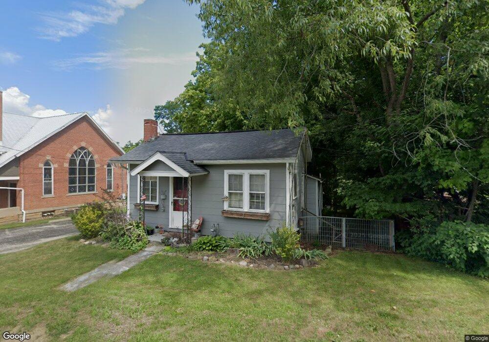
24 Maine St Ashland, OH 44805
Estimated Value: $74,337 - $145,000
2
Beds
1
Bath
622
Sq Ft
$182/Sq Ft
Est. Value
About This Home
This home is located at 24 Maine St, Ashland, OH 44805 and is currently estimated at $113,334, approximately $182 per square foot. 24 Maine St is a home located in Ashland County with nearby schools including Hillsdale Elementary School, Hillsdale Middle School, and Hillsdale High School.
Ownership History
Date
Name
Owned For
Owner Type
Purchase Details
Closed on
Jun 23, 2022
Sold by
Bolen Robert and Bolen Rebecca
Bought by
Bolen Robert Leonard and Bolen Elizabeth Ann
Current Estimated Value
Purchase Details
Closed on
Mar 5, 1999
Sold by
Hall Rev Robert F
Bought by
Bolen Robert
Purchase Details
Closed on
Jul 6, 1998
Sold by
Markley Ethel G
Bought by
Hall Rev Robert F
Purchase Details
Closed on
Dec 18, 1997
Sold by
Good Florence
Bought by
Markley Ethel G
Purchase Details
Closed on
Oct 20, 1997
Sold by
Good Ray
Bought by
Good Florence
Purchase Details
Closed on
Jan 1, 1990
Bought by
Good Ray
Create a Home Valuation Report for This Property
The Home Valuation Report is an in-depth analysis detailing your home's value as well as a comparison with similar homes in the area
Home Values in the Area
Average Home Value in this Area
Purchase History
| Date | Buyer | Sale Price | Title Company |
|---|---|---|---|
| Bolen Robert Leonard | -- | New Title Company Name | |
| Bolen Robert | $30,000 | -- | |
| Hall Rev Robert F | $40,000 | -- | |
| Markley Ethel G | $17,300 | -- | |
| Good Florence | $800 | -- | |
| Good Ray | -- | -- |
Source: Public Records
Tax History Compared to Growth
Tax History
| Year | Tax Paid | Tax Assessment Tax Assessment Total Assessment is a certain percentage of the fair market value that is determined by local assessors to be the total taxable value of land and additions on the property. | Land | Improvement |
|---|---|---|---|---|
| 2024 | $550 | $17,120 | $3,750 | $13,370 |
| 2023 | $550 | $17,120 | $3,750 | $13,370 |
| 2022 | $548 | $13,170 | $2,880 | $10,290 |
| 2021 | $549 | $13,170 | $2,880 | $10,290 |
| 2020 | $514 | $13,170 | $2,880 | $10,290 |
| 2019 | $534 | $13,320 | $2,750 | $10,570 |
| 2018 | $531 | $13,320 | $2,750 | $10,570 |
| 2017 | $492 | $13,320 | $2,750 | $10,570 |
| 2016 | $492 | $12,240 | $2,170 | $10,070 |
| 2015 | $486 | $12,240 | $2,170 | $10,070 |
| 2013 | $521 | $12,130 | $2,250 | $9,880 |
Source: Public Records
Map
Nearby Homes
- 19 Maine St
- 1183 County Road 30a
- 1106 County Road 30a
- 945 Pike Dr
- 3290 Shad Dr W
- 775 Touby Ln
- 1048 Township Road 2156
- 2750 Lutz Ave
- 1696 Township Road 1419
- 2495 Emma Ln
- 0 Mount Zion Rd Unit 9069748
- 0 Satinwood Dr
- 2364 Satinwood Dr
- 1015 Township Road 1696
- 598 Impala Dr
- 1690 County Road 995
- 2236 Lakecrest Dr
- 0 Peterson Rd