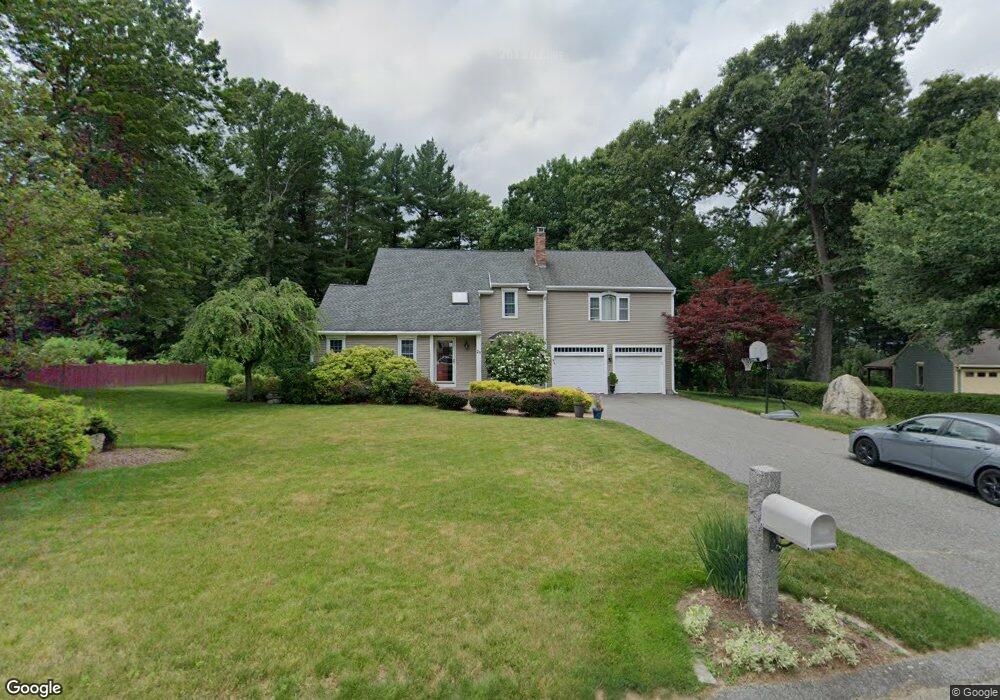
24 Merrill Rd Sutton, MA 01590
Estimated Value: $571,000 - $783,000
4
Beds
3
Baths
2,542
Sq Ft
$275/Sq Ft
Est. Value
About This Home
This home is located at 24 Merrill Rd, Sutton, MA 01590 and is currently estimated at $698,689, approximately $274 per square foot. 24 Merrill Rd is a home located in Worcester County with nearby schools including Sutton Elementary School, Sutton Middle School, and Sutton High School.
Ownership History
Date
Name
Owned For
Owner Type
Purchase Details
Closed on
May 28, 1999
Sold by
Dipietro Denise L and Dipierto Richard P
Bought by
Frascolla Michael G and Carter Lori
Current Estimated Value
Purchase Details
Closed on
Nov 28, 1989
Sold by
Cameron Laurence
Bought by
Cameron Denise
Create a Home Valuation Report for This Property
The Home Valuation Report is an in-depth analysis detailing your home's value as well as a comparison with similar homes in the area
Home Values in the Area
Average Home Value in this Area
Purchase History
| Date | Buyer | Sale Price | Title Company |
|---|---|---|---|
| Frascolla Michael G | $194,000 | -- | |
| Cameron Denise | $19,500 | -- |
Source: Public Records
Mortgage History
| Date | Status | Borrower | Loan Amount |
|---|---|---|---|
| Open | Cameron Denise | $249,000 | |
| Closed | Cameron Denise | $50,000 |
Source: Public Records
Tax History
| Year | Tax Paid | Tax Assessment Tax Assessment Total Assessment is a certain percentage of the fair market value that is determined by local assessors to be the total taxable value of land and additions on the property. | Land | Improvement |
|---|---|---|---|---|
| 2025 | $7,719 | $619,500 | $166,500 | $453,000 |
| 2024 | $7,637 | $592,500 | $159,000 | $433,500 |
| 2023 | $7,198 | $511,200 | $143,800 | $367,400 |
| 2022 | $6,877 | $443,100 | $109,700 | $333,400 |
| 2021 | $6,748 | $413,200 | $109,700 | $303,500 |
| 2020 | $6,756 | $413,200 | $109,700 | $303,500 |
| 2019 | $6,467 | $381,300 | $105,900 | $275,400 |
| 2018 | $6,202 | $364,600 | $105,900 | $258,700 |
| 2017 | $6,084 | $358,700 | $93,300 | $265,400 |
| 2016 | $5,978 | $348,600 | $93,300 | $255,300 |
| 2015 | $5,734 | $335,300 | $93,300 | $242,000 |
| 2014 | $5,602 | $321,200 | $96,300 | $224,900 |
Source: Public Records
Map
Nearby Homes
- 66 Buttonwood Ave
- 20 Millers Way Unit C
- 150 Ariel Cir
- 5 Wildflower Dr
- 175 Armsby Rd
- 229 Worcester-Providence Turnpike
- 8 Autumn Gate Cir
- 90 Leland Hill Rd
- Lot 1 Cooper Rd
- 53 Fisherville Terrace
- 64 Fisherville Terrace
- 62 Fisherville Terrace
- 58 Fisherville Terrace
- 99 Burbank Road Lot 182
- 99 Burbank Rd
- 5 Mogren Dr
- 2 Jessica j Dr
- 4 Jessica j Dr
- 9 Danielle Dr
- 82 Central Turnpike
Your Personal Tour Guide
Ask me questions while you tour the home.