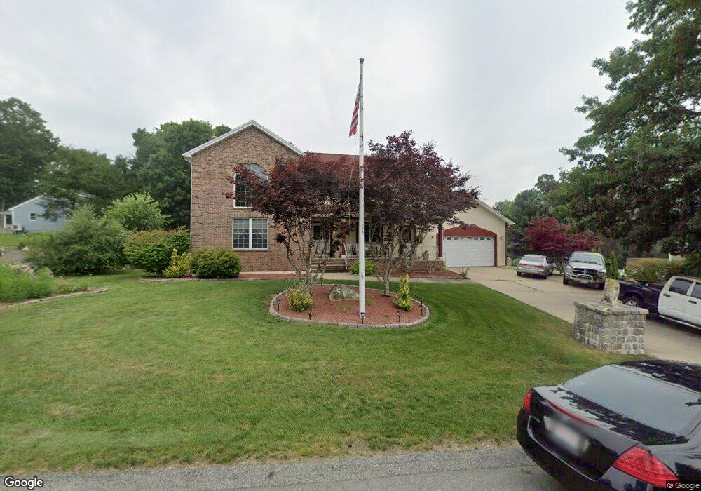
24 Reservation Rd Acushnet, MA 02743
Sherwood Forest NeighborhoodEstimated Value: $765,000 - $929,000
3
Beds
3
Baths
3,380
Sq Ft
$245/Sq Ft
Est. Value
About This Home
This home is located at 24 Reservation Rd, Acushnet, MA 02743 and is currently estimated at $827,118, approximately $244 per square foot. 24 Reservation Rd is a home located in Bristol County with nearby schools including Acushnet Elementary School, Albert F Ford Middle School, and Alma del Mar Charter School.
Ownership History
Date
Name
Owned For
Owner Type
Purchase Details
Closed on
Jan 19, 2005
Sold by
Cabral Antonio J and Cabral Rosa J
Bought by
Teixeira Carlos
Current Estimated Value
Home Financials for this Owner
Home Financials are based on the most recent Mortgage that was taken out on this home.
Original Mortgage
$330,000
Interest Rate
5.71%
Mortgage Type
Purchase Money Mortgage
Create a Home Valuation Report for This Property
The Home Valuation Report is an in-depth analysis detailing your home's value as well as a comparison with similar homes in the area
Home Values in the Area
Average Home Value in this Area
Purchase History
| Date | Buyer | Sale Price | Title Company |
|---|---|---|---|
| Teixeira Carlos | $480,000 | -- |
Source: Public Records
Mortgage History
| Date | Status | Borrower | Loan Amount |
|---|---|---|---|
| Open | Teixeira Carlos | $350,000 | |
| Closed | Teixeira Carlos | $149,500 | |
| Closed | Teixeira Carlos | $330,000 | |
| Previous Owner | Teixeira Carlos | $100,000 |
Source: Public Records
Tax History
| Year | Tax Paid | Tax Assessment Tax Assessment Total Assessment is a certain percentage of the fair market value that is determined by local assessors to be the total taxable value of land and additions on the property. | Land | Improvement |
|---|---|---|---|---|
| 2025 | $84 | $774,100 | $160,900 | $613,200 |
| 2024 | $7,850 | $688,000 | $140,700 | $547,300 |
| 2023 | $7,832 | $652,700 | $128,200 | $524,500 |
| 2022 | $7,017 | $528,800 | $120,600 | $408,200 |
| 2021 | $6,900 | $498,900 | $120,600 | $378,300 |
| 2020 | $6,955 | $498,900 | $120,600 | $378,300 |
| 2019 | $7,050 | $497,200 | $126,700 | $370,500 |
| 2018 | $6,776 | $469,900 | $126,700 | $343,200 |
| 2017 | $7,188 | $497,800 | $126,700 | $371,100 |
| 2016 | $6,758 | $465,100 | $126,700 | $338,400 |
| 2015 | $6,642 | $465,100 | $126,700 | $338,400 |
Source: Public Records
Map
Nearby Homes
- 134 Nyes Ln
- 329 Middle Rd
- 1015 Forbes St
- 40 Foley Dr
- SS Charbonneau Ln
- ES Acushnet Ave
- 765 Pine Hill Dr
- 145 Heritage Dr
- 7 Hamlin St
- 34 Poplar Rd
- 1044 Phillips Rd Unit 25
- 1044 Phillips Rd Unit 20
- WS Phillips Rd
- ES Phillips Rd
- 23 Coury Dr
- 2800 Acushnet Ave
- 1251 Church St Unit 10
- 1261 Church St Unit 70
- 1261 Church St Unit 53
- 1261 Church St Unit 46
Your Personal Tour Guide
Ask me questions while you tour the home.