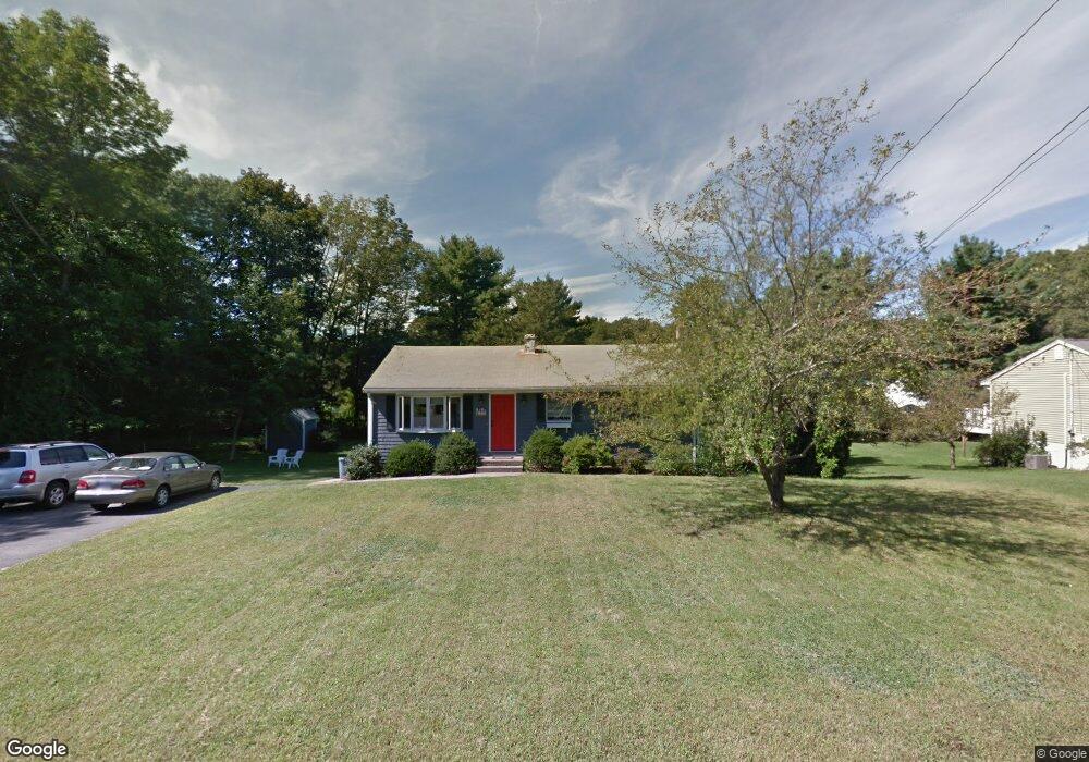
24 Sunset Rd Franklin, MA 02038
Estimated Value: $552,000 - $571,000
2
Beds
2
Baths
1,176
Sq Ft
$480/Sq Ft
Est. Value
About This Home
This home is located at 24 Sunset Rd, Franklin, MA 02038 and is currently estimated at $564,214, approximately $479 per square foot. 24 Sunset Rd is a home located in Norfolk County with nearby schools including John F. Kennedy Memorial School, Horace Mann Middle School, and Franklin High School.
Ownership History
Date
Name
Owned For
Owner Type
Purchase Details
Closed on
May 10, 2024
Sold by
Hassell David F and Hassell Terri A
Bought by
Hassell 2024 Irt and Hassell
Current Estimated Value
Purchase Details
Closed on
Jul 31, 2017
Sold by
Hassell David F
Bought by
Hassell David F and Hassell Terri A
Purchase Details
Closed on
Sep 28, 1984
Bought by
Hassell David F
Create a Home Valuation Report for This Property
The Home Valuation Report is an in-depth analysis detailing your home's value as well as a comparison with similar homes in the area
Home Values in the Area
Average Home Value in this Area
Purchase History
| Date | Buyer | Sale Price | Title Company |
|---|---|---|---|
| Hassell 2024 Irt | -- | None Available | |
| Hassell 2024 Irt | -- | None Available | |
| Hassell David F | -- | -- | |
| Hassell David F | $74,000 | -- | |
| Hassell David F | -- | -- |
Source: Public Records
Mortgage History
| Date | Status | Borrower | Loan Amount |
|---|---|---|---|
| Previous Owner | Hassell David F | $48,000 | |
| Previous Owner | Hassell David F | $15,000 |
Source: Public Records
Tax History Compared to Growth
Tax History
| Year | Tax Paid | Tax Assessment Tax Assessment Total Assessment is a certain percentage of the fair market value that is determined by local assessors to be the total taxable value of land and additions on the property. | Land | Improvement |
|---|---|---|---|---|
| 2025 | $5,741 | $494,100 | $244,500 | $249,600 |
| 2024 | $5,530 | $469,000 | $244,500 | $224,500 |
| 2023 | $5,470 | $434,800 | $255,100 | $179,700 |
| 2022 | $5,128 | $365,000 | $210,800 | $154,200 |
| 2021 | $4,754 | $324,500 | $206,800 | $117,700 |
| 2020 | $4,843 | $333,800 | $222,200 | $111,600 |
| 2019 | $4,583 | $312,600 | $201,000 | $111,600 |
| 2018 | $4,540 | $309,900 | $210,600 | $99,300 |
| 2017 | $4,265 | $292,500 | $193,200 | $99,300 |
| 2016 | $4,211 | $290,400 | $206,100 | $84,300 |
| 2015 | $3,953 | $266,400 | $182,100 | $84,300 |
| 2014 | $3,701 | $256,100 | $171,800 | $84,300 |
Source: Public Records
Map
Nearby Homes
- 2 Noanet Brook Ln
- 208 Irondequoit Rd
- 60 Southgate Rd
- 214 Conlyn Ave
- 41 Kimberlee Ave
- 1805 Franklin Crossing Rd
- 159 Highwood Dr
- 2211 Franklin Crossing Rd Unit 2211
- 336 Maple St
- 605 Franklin Crossing Rd
- 66 Highwood Dr
- 31 Highwood Dr
- 2 Kayla Dr
- 17 Pine St
- 951 Pond St
- 57 Raymond St Unit 2
- 14 Hawthorne Village Unit D
- 33 Stone Ridge Rd Unit 33
- 18 Mary Anne Dr
- 109 Stone Ridge Rd Unit 109