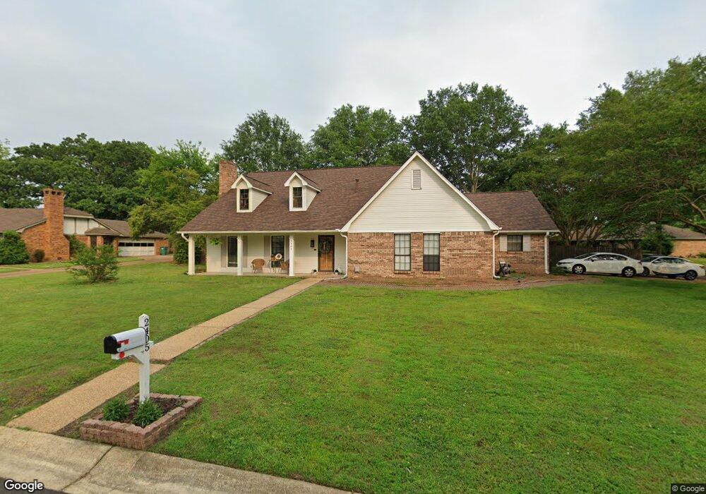
2405 Philp Dr Tupelo, MS 38801
Estimated Value: $248,000 - $313,727
Studio
1
Bath
1,553
Sq Ft
$178/Sq Ft
Est. Value
About This Home
This home is located at 2405 Philp Dr, Tupelo, MS 38801 and is currently estimated at $275,932, approximately $177 per square foot. 2405 Philp Dr is a home located in Lee County with nearby schools including Lawndale Elementary School, Parkway Elementary School, and Tupelo Middle School.
Ownership History
Date
Name
Owned For
Owner Type
Purchase Details
Closed on
Feb 12, 2016
Sold by
Renasant Bank
Bought by
Garcia Rodrigo and Garcia Lesley
Current Estimated Value
Home Financials for this Owner
Home Financials are based on the most recent Mortgage that was taken out on this home.
Original Mortgage
$132,554
Outstanding Balance
$104,693
Interest Rate
3.75%
Mortgage Type
FHA
Estimated Equity
$171,239
Purchase Details
Closed on
Mar 20, 2008
Sold by
Mitchell Allison Oakes and Mitchell Charles B
Bought by
Harris John Britt and Harris Rachel A
Home Financials for this Owner
Home Financials are based on the most recent Mortgage that was taken out on this home.
Original Mortgage
$142,762
Interest Rate
5.63%
Create a Home Valuation Report for This Property
The Home Valuation Report is an in-depth analysis detailing your home's value as well as a comparison with similar homes in the area
Purchase History
We collect this data history from publicly available records. To have your information removed, we recommend requesting removal directly through your county’s website.
| Date | Buyer | Sale Price | Title Company |
|---|---|---|---|
| Garcia Rodrigo | -- | -- | |
| Harris John Britt | -- | -- |
Source: Public Records
Mortgage History
We collect this data history from publicly available records. To have your information removed, we recommend requesting removal directly through your county’s website.
| Date | Status | Borrower | Loan Amount |
|---|---|---|---|
| Open | Garcia Rodrigo | $132,554 | |
| Previous Owner | Harris John Britt | $142,762 |
Source: Public Records
Tax History
| Year | Tax Paid | Tax Assessment Tax Assessment Total Assessment is a certain percentage of the fair market value that is determined by local assessors to be the total taxable value of land and additions on the property. | Land | Improvement |
|---|---|---|---|---|
| 2025 | $2,894 | $21,284 | $0 | $0 |
| 2024 | $2,894 | $21,284 | $0 | $0 |
| 2023 | $2,460 | $18,379 | $0 | $0 |
| 2022 | $3,690 | $27,569 | $0 | $0 |
| 2021 | $2,160 | $18,379 | $0 | $0 |
| 2020 | $2,460 | $18,379 | $0 | $0 |
| 2019 | $2,050 | $17,556 | $0 | $0 |
| 2018 | $2,050 | $17,556 | $0 | $0 |
| 2017 | $2,041 | $17,556 | $0 | $0 |
| 2016 | $3,511 | $26,334 | $0 | $0 |
| 2015 | $1,946 | $16,907 | $0 | $0 |
| 2014 | $1,946 | $16,907 | $0 | $0 |
Source: Public Records
Map
Nearby Homes
- 1213 Winwood Cove
- 2022 Hummingbird Ln
- 1914 Cardinal Dr
- 2010 Lawndale Dr
- 2102 Fillmore Dr
- 2006 Fillmore Dr
- 1206 Mockingbird Ln
- 1585 Cedar Grove Rd
- 1015 Taft St
- 1901 Swallow Ln
- 1009 Taft St
- 1712 Valley View Dr
- 911 Rockefeller Ave
- 0 (3 Acres) S Thomas St
- Lot 3 Cliff Gookin Blvd
- 0 Cliff Gookin Blvd
- 2 ac Cliff Gookin Blvd
- Lot 4 Cliff Gookin Blvd
- Lot 2 Cliff Gookin Blvd
- Lot 1 Cliff Gookin Blvd
Your Personal Tour Guide
Ask me questions while you tour the home.