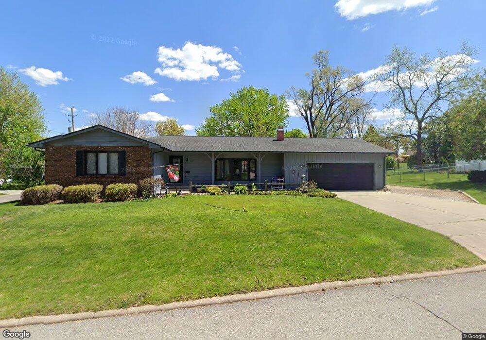
2407 Kaiser Ct Waterloo, IA 50701
Estimated Value: $256,000 - $293,000
3
Beds
3
Baths
1,500
Sq Ft
$177/Sq Ft
Est. Value
About This Home
This home is located at 2407 Kaiser Ct, Waterloo, IA 50701 and is currently estimated at $265,471, approximately $176 per square foot. 2407 Kaiser Ct is a home located in Black Hawk County with nearby schools including Kingsley Elementary School, Hoover Middle School, and West High School.
Ownership History
Date
Name
Owned For
Owner Type
Purchase Details
Closed on
Jul 30, 2020
Sold by
Knutson Brenda K
Bought by
Donald E Bartlett Revocable Trust
Current Estimated Value
Purchase Details
Closed on
Dec 6, 2016
Sold by
Knutson Mark E and Knutson Brenda K
Bought by
Knutson Mark E and Knutson Brenda K
Create a Home Valuation Report for This Property
The Home Valuation Report is an in-depth analysis detailing your home's value as well as a comparison with similar homes in the area
Purchase History
| Date | Buyer | Sale Price | Title Company |
|---|---|---|---|
| Donald E Bartlett Revocable Trust | -- | None Available | |
| Knutson Mark E | -- | Attorney |
Source: Public Records
Tax History
| Year | Tax Paid | Tax Assessment Tax Assessment Total Assessment is a certain percentage of the fair market value that is determined by local assessors to be the total taxable value of land and additions on the property. | Land | Improvement |
|---|---|---|---|---|
| 2025 | $4,950 | $286,840 | $35,020 | $251,820 |
| 2024 | $4,950 | $252,100 | $35,020 | $217,080 |
| 2023 | $4,664 | $252,100 | $35,020 | $217,080 |
| 2022 | $4,664 | $221,230 | $35,020 | $186,210 |
| 2021 | $4,539 | $221,230 | $35,020 | $186,210 |
| 2020 | $4,200 | $197,290 | $28,010 | $169,280 |
| 2019 | $4,200 | $197,290 | $28,010 | $169,280 |
| 2018 | $4,204 | $197,290 | $28,010 | $169,280 |
| 2017 | $4,336 | $197,290 | $28,010 | $169,280 |
| 2016 | $4,278 | $197,290 | $28,010 | $169,280 |
| 2015 | $4,278 | $197,290 | $28,010 | $169,280 |
| 2014 | $4,360 | $197,290 | $28,010 | $169,280 |
Source: Public Records
Map
Nearby Homes
- 2310 Westview Ave
- 608-610 Martin Rd
- 1132 W Ridgeway Ave
- 0 Provision Pkwy
- 3329 Lincolnshire Rd
- 3335 Lincolnshire Rd
- 3325 Lincolnshire Rd
- 910 Campbell Ave
- Village West 2nd Addn Lot 2
- 0 Hwy 63 Land Unit NBR20254281
- 0 Hwy 63 Land Unit NBR20255994
- 1119 Rachael St
- 514 Columbia Cir
- Lot 10 Paradise Estates First Addition
- Lot 44 Paradise Estates First Addition
- Lot 29 Paradise Estates First Addition
- Lot 1
- Lot 27 Paradise Estates First Addition
- Lot 54 Paradise Estates First Addition
- Lot 63 Paradise Estates First Addition
- 415 Martin Rd
- 400 Martin Rd
- 2408 Kaiser Ct
- 322 Martin Rd
- 315 Martin Rd
- 2425 Kaiser Ct
- 416 Martin Rd
- 2420 Kaiser Ct
- 316 Martin Rd
- 2416 Ansborough Ave
- 423 Martin Rd
- 2324 Westview Ave Unit 2326
- 308 Martin Rd
- 2325 Westview Ave
- 306-308 Martin Rd
- 2421 Michelle Dr
- 306 Martin Rd
- 2428 Kaiser Ct
- 2318 Westview Ave
- 2500 Ansborough Ave
Your Personal Tour Guide
Ask me questions while you tour the home.