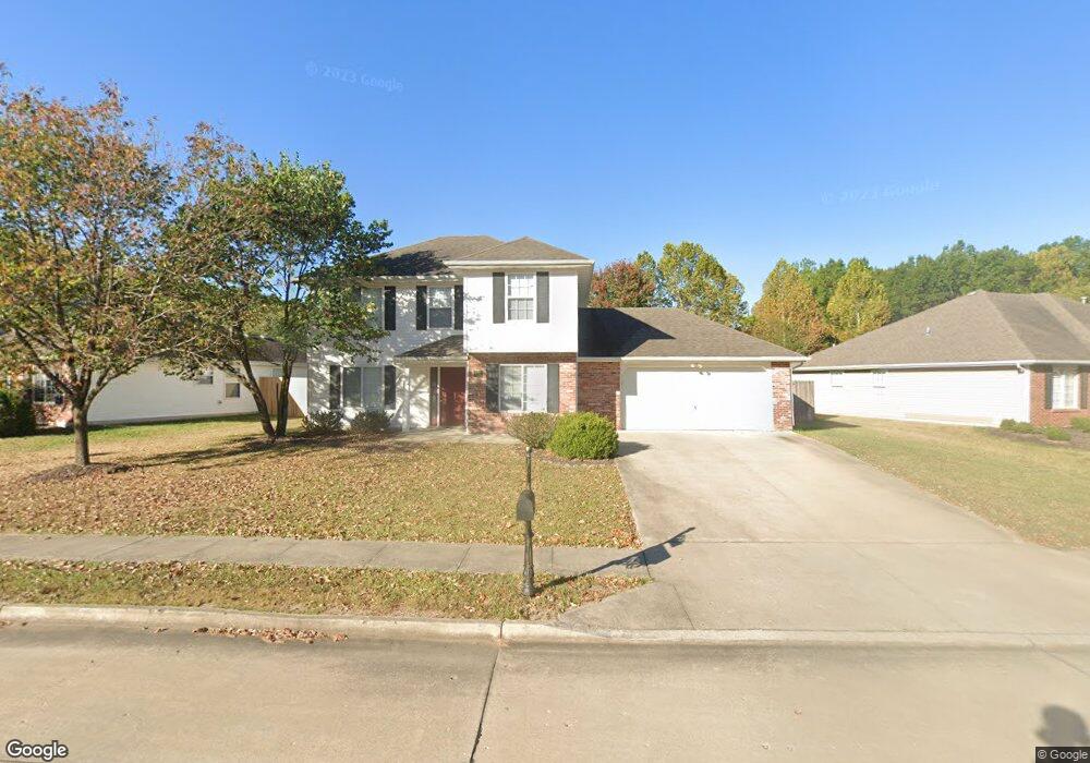
2409 Lubbock Ct Columbia, MO 65201
Estimated Value: $296,000 - $352,000
3
Beds
3
Baths
1,707
Sq Ft
$195/Sq Ft
Est. Value
About This Home
This home is located at 2409 Lubbock Ct, Columbia, MO 65201 and is currently estimated at $332,519, approximately $194 per square foot. 2409 Lubbock Ct is a home located in Boone County with nearby schools including Locust Street Expressive Arts Elementary School, Jefferson Middle School, and Rock Bridge High School.
Ownership History
Date
Name
Owned For
Owner Type
Purchase Details
Closed on
Jan 31, 2022
Sold by
Kafilat Soyoye and Kafilat Olasunkanmi
Bought by
Zties Family Llc
Current Estimated Value
Purchase Details
Closed on
Jun 16, 2008
Sold by
Rodeheaver Frederick and Rodeheaver Lori
Bought by
Soyoye Tajudeen
Home Financials for this Owner
Home Financials are based on the most recent Mortgage that was taken out on this home.
Original Mortgage
$167,000
Interest Rate
6.07%
Mortgage Type
Purchase Money Mortgage
Create a Home Valuation Report for This Property
The Home Valuation Report is an in-depth analysis detailing your home's value as well as a comparison with similar homes in the area
Home Values in the Area
Average Home Value in this Area
Purchase History
| Date | Buyer | Sale Price | Title Company |
|---|---|---|---|
| Zties Family Llc | -- | None Listed On Document | |
| Soyoye Tajudeen | -- | Boone Central Title Company |
Source: Public Records
Mortgage History
| Date | Status | Borrower | Loan Amount |
|---|---|---|---|
| Previous Owner | Soyoye Tajudeen | $167,000 |
Source: Public Records
Tax History Compared to Growth
Tax History
| Year | Tax Paid | Tax Assessment Tax Assessment Total Assessment is a certain percentage of the fair market value that is determined by local assessors to be the total taxable value of land and additions on the property. | Land | Improvement |
|---|---|---|---|---|
| 2025 | $2,333 | $39,596 | $3,629 | $35,967 |
| 2024 | $2,333 | $34,580 | $3,629 | $30,951 |
| 2023 | $2,314 | $34,580 | $3,629 | $30,951 |
| 2022 | $2,140 | $32,015 | $3,629 | $28,386 |
| 2021 | $2,144 | $32,015 | $3,629 | $28,386 |
| 2020 | $2,113 | $29,651 | $3,629 | $26,022 |
| 2019 | $2,113 | $29,651 | $3,629 | $26,022 |
| 2018 | $1,970 | $0 | $0 | $0 |
| 2017 | $1,946 | $27,455 | $3,629 | $23,826 |
| 2016 | $1,998 | $27,455 | $3,629 | $23,826 |
| 2015 | $1,843 | $27,455 | $3,629 | $23,826 |
| 2014 | -- | $27,455 | $3,629 | $23,826 |
Source: Public Records
Map
Nearby Homes
- 479 Foxfire Dr Unit 71D
- 423 Foxfire Dr Unit 35C
- 305 Bennett Springs Ct
- 517 Huntridge Dr Unit 8B
- 2802 Melody Ln Unit 3A
- 104 W Green Meadows Rd
- 104 W Green Meadows Rd Unit 18
- 8 E Alhambra Dr
- 3615 Madera Dr
- 715 Columbine Ct
- 2416 Cimarron Dr
- 1601 Telluride Ln
- 1201 S Old Hwy 63 Unit 402
- 603 N Brookline Dr
- 1702 Telluride Ln
- 3310 Lynnwood Dr
- 2702 Lynnwood Dr
- 400 & 420 N Village Cir
- 2516 Lynnwood Dr
- 0 N Village Cir
- 2411 Lubbock Ct
- 903 Norman Dr
- 2405 Lubbock Ct
- 2406 Lubbock Ct
- 2408 Lubbock Ct
- 2404 Lubbock Ct
- 2410 Lubbock Ct
- 904 Norman Dr
- 902 Norman Dr
- 906 Norman Dr
- 809 Norman Dr
- 900 Norman Dr
- 2403 Lubbock Ct
- 2402 Lubbock Ct
- 1000 Norman Dr
- 810 Norman Dr
- 2400 Lubbock Ct
- 1002 Norman Dr
- 807 Norman Dr
- 903 Manhattan Dr