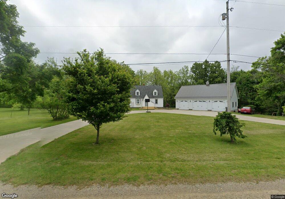
24118 M 78 Battle Creek, MI 49017
Estimated Value: $221,000 - $281,000
3
Beds
2
Baths
1,281
Sq Ft
$202/Sq Ft
Est. Value
About This Home
This home is located at 24118 M 78, Battle Creek, MI 49017 and is currently estimated at $258,361, approximately $201 per square foot. 24118 M 78 is a home located in Calhoun County with nearby schools including North Pennfield Elementary School, Pennfield Dunlap Elementary School, and Pennfield Middle School.
Ownership History
Date
Name
Owned For
Owner Type
Purchase Details
Closed on
Dec 11, 2013
Sold by
Anderson Ronald and Greta E Anderson Revocable Tru
Bought by
Niemann Justin
Current Estimated Value
Home Financials for this Owner
Home Financials are based on the most recent Mortgage that was taken out on this home.
Original Mortgage
$91,836
Outstanding Balance
$68,911
Interest Rate
4.31%
Mortgage Type
New Conventional
Estimated Equity
$189,450
Create a Home Valuation Report for This Property
The Home Valuation Report is an in-depth analysis detailing your home's value as well as a comparison with similar homes in the area
Home Values in the Area
Average Home Value in this Area
Purchase History
| Date | Buyer | Sale Price | Title Company |
|---|---|---|---|
| Niemann Justin | $90,000 | Attorneys Title Agency Of So |
Source: Public Records
Mortgage History
| Date | Status | Borrower | Loan Amount |
|---|---|---|---|
| Open | Niemann Justin | $91,836 |
Source: Public Records
Tax History Compared to Growth
Tax History
| Year | Tax Paid | Tax Assessment Tax Assessment Total Assessment is a certain percentage of the fair market value that is determined by local assessors to be the total taxable value of land and additions on the property. | Land | Improvement |
|---|---|---|---|---|
| 2025 | $3,236 | $123,200 | $0 | $0 |
| 2024 | $1,473 | $107,100 | $0 | $0 |
| 2023 | $2,855 | $100,730 | $0 | $0 |
| 2022 | $1,336 | $92,200 | $0 | $0 |
| 2021 | $2,804 | $78,330 | $0 | $0 |
| 2020 | $2,758 | $75,460 | $0 | $0 |
| 2019 | $2,052 | $55,130 | $0 | $0 |
| 2018 | $1,889 | $54,180 | $12,330 | $41,850 |
| 2017 | $0 | $53,450 | $0 | $0 |
| 2016 | $0 | $50,400 | $0 | $0 |
| 2015 | -- | $50,160 | $21,227 | $28,933 |
| 2014 | -- | $44,990 | $21,227 | $23,763 |
Source: Public Records
Map
Nearby Homes
- 24190 Michigan 78
- 22975 Pine Lake Rd
- 23720 M 78
- 0 Lynch Rd Unit 25041472
- 10950 W Dr N
- 9559 Brian Dr
- 22485 Clear Lake Rd N
- 11303 W Dr N
- 332 Community Dr
- 21534 Clear Lake Ave
- 22511 Capital Ave NE
- 8290 Huff Rd
- V/L 12 1 2 Mile Rd
- 10122 E Jones Rd
- 0 S Lacey Lake Rd Unit 289887
- 9913 E Jones Rd
- 20291 Chippewa Trail
- 21520 Swafford Rd
- 20259 Pine Lake Rd
- 12986 Bellevue Rd