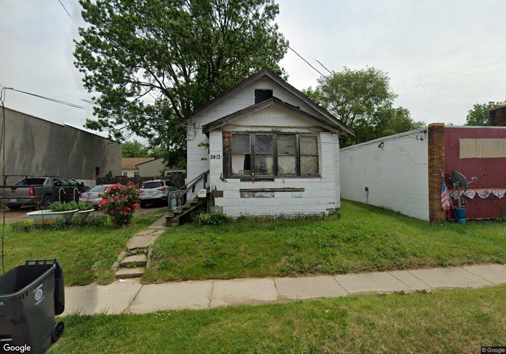
2413 Fenton Rd Flint, MI 48507
South Side NeighborhoodEstimated Value: $28,000 - $49,000
--
Bed
1
Bath
616
Sq Ft
$63/Sq Ft
Est. Value
About This Home
This home is located at 2413 Fenton Rd, Flint, MI 48507 and is currently estimated at $38,892, approximately $63 per square foot. 2413 Fenton Rd is a home located in Genesee County with nearby schools including Eisenhower School, Flint Southwestern Classical Academy, and International Academy of Flint (K-12).
Ownership History
Date
Name
Owned For
Owner Type
Purchase Details
Closed on
Mar 29, 2006
Sold by
Rose Land & Finance Corp
Bought by
Maclin John W and Maclin Roxann
Current Estimated Value
Purchase Details
Closed on
Mar 1, 2006
Sold by
First National Bank Of America
Bought by
Rose Land & Finance Corp
Purchase Details
Closed on
Oct 11, 2005
Sold by
Saunders Ginger L
Bought by
First National Bank Of America
Purchase Details
Closed on
Nov 19, 1982
Sold by
Christensen Christensen G and Christensen Lela
Bought by
Saunders Ginger Lee
Create a Home Valuation Report for This Property
The Home Valuation Report is an in-depth analysis detailing your home's value as well as a comparison with similar homes in the area
Home Values in the Area
Average Home Value in this Area
Purchase History
| Date | Buyer | Sale Price | Title Company |
|---|---|---|---|
| Maclin John W | -- | Greco Title | |
| Rose Land & Finance Corp | -- | Greco Title | |
| First National Bank Of America | -- | -- | |
| Saunders Ginger Lee | $12,000 | Guaranty Title Company |
Source: Public Records
Tax History Compared to Growth
Tax History
| Year | Tax Paid | Tax Assessment Tax Assessment Total Assessment is a certain percentage of the fair market value that is determined by local assessors to be the total taxable value of land and additions on the property. | Land | Improvement |
|---|---|---|---|---|
| 2025 | $598 | $13,600 | $0 | $0 |
| 2024 | $556 | $12,000 | $0 | $0 |
| 2023 | $554 | $10,900 | $0 | $0 |
| 2022 | $0 | $9,700 | $0 | $0 |
| 2021 | $566 | $7,400 | $0 | $0 |
| 2020 | $525 | $6,400 | $0 | $0 |
| 2019 | $520 | $5,700 | $0 | $0 |
| 2018 | $490 | $5,200 | $0 | $0 |
| 2017 | $482 | $0 | $0 | $0 |
| 2016 | $480 | $0 | $0 | $0 |
| 2015 | -- | $0 | $0 | $0 |
| 2014 | -- | $0 | $0 | $0 |
| 2012 | -- | $6,900 | $0 | $0 |
Source: Public Records
Map
Nearby Homes
- 930 Bloor Ave
- 842 Ossington Ave
- 812 Remington Ave
- 2021 Brooks St
- 843 Ossington Ave
- 909 Barrie Ave
- 1708 Fenton Rd
- 839 Barrie Ave
- 839 SiMcOe Ave
- 734 Barrie Ave
- 741 Barrie Ave
- 647 Monroe St
- 639 Monroe St
- 657 Barrie Ave
- 730 Freeman Ave
- 517 Morley Ave
- 820 Vermilya Ave
- 618 Barrie Ave
- 745 Freeman Ave
- 936 Lincoln Ave
- 2403 Fenton Rd
- 962 Paddington Ave
- 951 Lexington Ave
- 950 Paddington Ave
- 947 Lexington Ave
- 939 Lexington Ave
- 958 Lexington Ave
- 938 Paddington Ave
- 954 Lexington Ave
- 950 Lexington Ave
- 2306 Fenton Rd
- 931 Lexington Ave
- 939 Paddington Ave
- 935 Lexington Ave
- 927 Lexington Ave
- 954 Remington Ave
- 950 Remington Ave
- 2510 Fenton Rd
- 916 Lexington Ave
- 946 Remington Ave