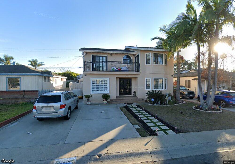
2414 Sebald Ave Redondo Beach, CA 90278
North Redondo Beach NeighborhoodEstimated Value: $1,757,000 - $2,413,000
4
Beds
2
Baths
2,107
Sq Ft
$1,016/Sq Ft
Est. Value
About This Home
This home is located at 2414 Sebald Ave, Redondo Beach, CA 90278 and is currently estimated at $2,140,046, approximately $1,015 per square foot. 2414 Sebald Ave is a home located in Los Angeles County with nearby schools including Lincoln Elementary School, Adams Middle School, and Redondo Union High School.
Ownership History
Date
Name
Owned For
Owner Type
Purchase Details
Closed on
Apr 10, 1996
Sold by
Lippert Lawrence James
Bought by
Amaro Oscar and Amaro Marilyn H
Current Estimated Value
Home Financials for this Owner
Home Financials are based on the most recent Mortgage that was taken out on this home.
Original Mortgage
$200,000
Outstanding Balance
$9,821
Interest Rate
7.8%
Estimated Equity
$2,130,225
Create a Home Valuation Report for This Property
The Home Valuation Report is an in-depth analysis detailing your home's value as well as a comparison with similar homes in the area
Home Values in the Area
Average Home Value in this Area
Purchase History
| Date | Buyer | Sale Price | Title Company |
|---|---|---|---|
| Amaro Oscar | -- | Chicago Title Co |
Source: Public Records
Mortgage History
| Date | Status | Borrower | Loan Amount |
|---|---|---|---|
| Open | Amaro Oscar | $200,000 |
Source: Public Records
Tax History
| Year | Tax Paid | Tax Assessment Tax Assessment Total Assessment is a certain percentage of the fair market value that is determined by local assessors to be the total taxable value of land and additions on the property. | Land | Improvement |
|---|---|---|---|---|
| 2025 | $7,087 | $551,927 | $330,912 | $221,015 |
| 2024 | $7,087 | $541,106 | $324,424 | $216,682 |
| 2023 | $6,968 | $530,497 | $318,063 | $212,434 |
| 2022 | $6,835 | $520,096 | $311,827 | $208,269 |
| 2021 | $6,641 | $509,899 | $305,713 | $204,186 |
| 2019 | $6,475 | $494,778 | $296,647 | $198,131 |
| 2018 | $6,244 | $485,078 | $290,831 | $194,247 |
| 2016 | $6,020 | $466,244 | $279,539 | $186,705 |
| 2015 | $5,916 | $459,242 | $275,341 | $183,901 |
| 2014 | $5,836 | $450,247 | $269,948 | $180,299 |
Source: Public Records
Map
Nearby Homes
- 2861 Pinckard Ave
- 2216 Bataan Rd Unit A
- 3211 Gibson Place
- 2813 Pinckard Ave
- 3310 Blossom Ln
- 2016 Farrell Ave Unit B
- 2016 Farrell Ave Unit A
- 2305 Graham Ave
- 2001 Bataan Rd
- 3202 Green Ln
- 4622 W 156th St
- 4711 W 165th St
- 2212 Gates Ave Unit B
- 2212 Gates Ave Unit A
- 4564 W 159th St
- 2517 Curtis Ave
- 2606 Gates Ave Unit 2
- 2406 Curtis Ave
- 4700 W 165th St
- 2308 Curtis Ave
- 2416 Sebald Ave
- 2412 Sebald Ave
- 2418 Sebald Ave
- 2410 Sebald Ave
- 2413 Burritt Ave
- 2411 Burritt Ave
- 2415 Burritt Ave
- 2409 Burritt Ave
- 2420 Sebald Ave
- 2408 Sebald Ave
- 2417 Burritt Ave
- 2415 Sebald Ave
- 2413 Sebald Ave
- 2417 Sebald Ave
- 2411 Sebald Ave
- 2407 Burritt Ave
- 2419 Burritt Ave
- 2422 Sebald Ave
- 2406 Sebald Ave
- 2409 Sebald Ave