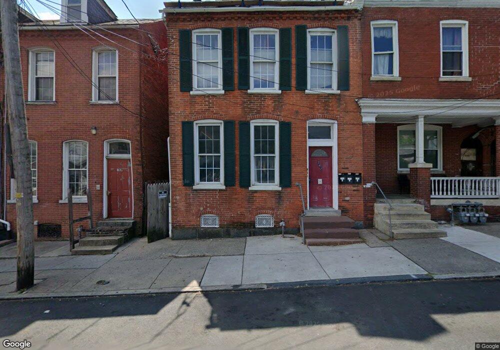
242 S Queen St Lancaster, PA 17603
Southside Lancaster NeighborhoodEstimated Value: $281,241 - $328,000
5
Beds
3
Baths
2,361
Sq Ft
$130/Sq Ft
Est. Value
About This Home
This home is located at 242 S Queen St, Lancaster, PA 17603 and is currently estimated at $307,810, approximately $130 per square foot. 242 S Queen St is a home located in Lancaster County with nearby schools including Carter & MacRae Elementary School, Reynolds Middle School, and McCaskey High School.
Ownership History
Date
Name
Owned For
Owner Type
Purchase Details
Closed on
Jan 22, 2001
Sold by
Rakowska Urszula K and Gonzalez Salvatore R
Bought by
Gross Phillip and Gross Maureen
Current Estimated Value
Home Financials for this Owner
Home Financials are based on the most recent Mortgage that was taken out on this home.
Original Mortgage
$55,930
Outstanding Balance
$20,606
Interest Rate
7.52%
Estimated Equity
$287,204
Purchase Details
Closed on
Feb 15, 2000
Sold by
King Gideon S
Bought by
Rakowska Urszula and Gonzalez Salvatore R
Purchase Details
Closed on
May 18, 1999
Sold by
Stoltzfus Jonas E and Stoltzfus Malinda E
Bought by
King Gideon S
Home Financials for this Owner
Home Financials are based on the most recent Mortgage that was taken out on this home.
Original Mortgage
$38,796
Interest Rate
6.88%
Create a Home Valuation Report for This Property
The Home Valuation Report is an in-depth analysis detailing your home's value as well as a comparison with similar homes in the area
Home Values in the Area
Average Home Value in this Area
Purchase History
| Date | Buyer | Sale Price | Title Company |
|---|---|---|---|
| Gross Phillip | $79,900 | -- | |
| Rakowska Urszula | $6,000 | -- | |
| King Gideon S | $43,000 | -- |
Source: Public Records
Mortgage History
| Date | Status | Borrower | Loan Amount |
|---|---|---|---|
| Open | Gross Phillip | $55,930 | |
| Previous Owner | King Gideon S | $38,796 | |
| Closed | King Gideon S | $38,796 |
Source: Public Records
Tax History Compared to Growth
Tax History
| Year | Tax Paid | Tax Assessment Tax Assessment Total Assessment is a certain percentage of the fair market value that is determined by local assessors to be the total taxable value of land and additions on the property. | Land | Improvement |
|---|---|---|---|---|
| 2025 | $3,443 | $87,000 | $9,100 | $77,900 |
| 2024 | $3,443 | $87,000 | $9,100 | $77,900 |
| 2023 | $3,385 | $87,000 | $9,100 | $77,900 |
| 2022 | $3,244 | $87,000 | $9,100 | $77,900 |
| 2021 | $3,174 | $87,000 | $9,100 | $77,900 |
| 2020 | $3,174 | $87,000 | $9,100 | $77,900 |
| 2019 | $3,127 | $87,000 | $9,100 | $77,900 |
| 2018 | $1,855 | $87,000 | $9,100 | $77,900 |
| 2017 | $2,903 | $63,200 | $12,600 | $50,600 |
| 2016 | $2,876 | $63,200 | $12,600 | $50,600 |
| 2015 | $1,122 | $63,200 | $12,600 | $50,600 |
| 2014 | $2,510 | $63,200 | $12,600 | $50,600 |
Source: Public Records
Map
Nearby Homes
- 316 Beaver St
- 14 E Farnum St
- 513 Howard Ave
- 341 S Prince St
- 507 Locust St
- 346 S Prince St
- 348 S Prince St
- 462 S Christian St
- 114 S Prince St
- 442 Fremont St
- 459 S Queen St
- 14 S Queen St
- 215 W Vine St
- 217 W Vine St
- 520 S Duke St
- 458 Poplar St
- 506 Beaver St
- 536 Woodward St
- 429 Hillside Ave
- 555 Woodward St
- 244 S Queen St
- 246 S Queen St
- 238 S Queen St
- 248 S Queen St
- 236 S Queen St
- 9 Conestoga St
- 234 S Queen St
- 13 Conestoga St
- 15 Conestoga St
- 243 Beaver St
- 17 Conestoga St
- 19 Conestoga St
- 241 Beaver St
- 239 Beaver St
- 237 Beaver St
- 308 S Queen St
- 21 Conestoga St
- 537 Church St
- 312 S Queen St
- 12 Conestoga St