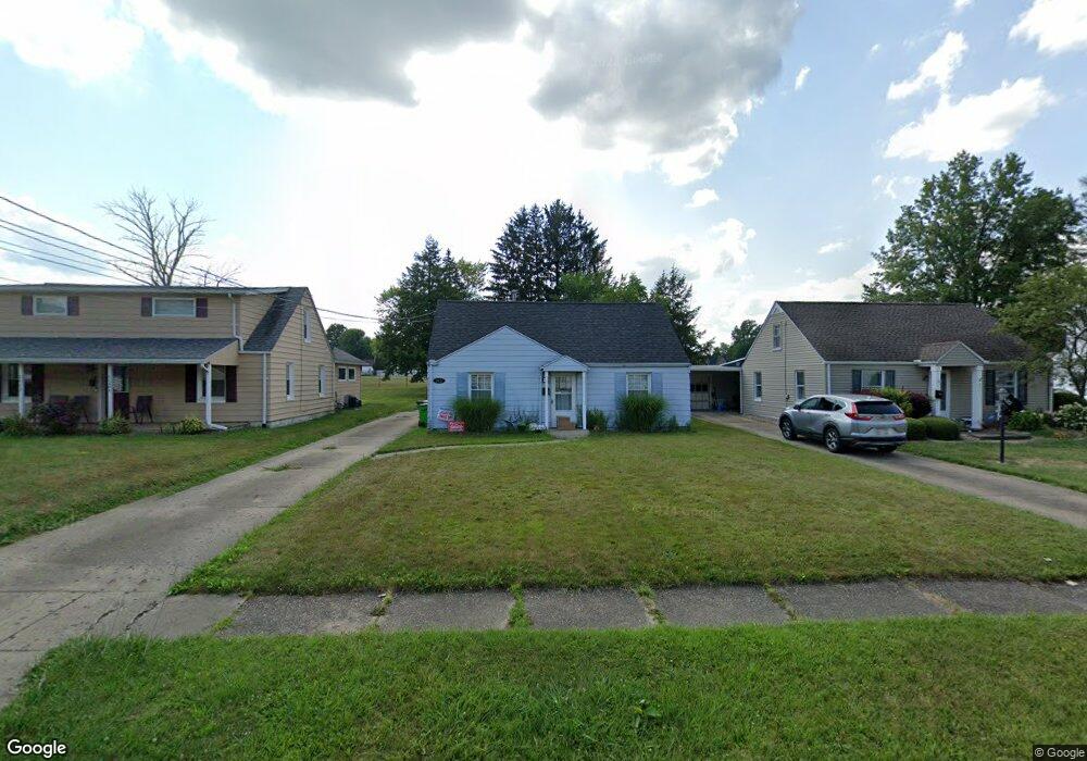
2425 Clark Ave Alliance, OH 44601
Estimated Value: $104,942 - $148,000
3
Beds
1
Bath
1,152
Sq Ft
$112/Sq Ft
Est. Value
About This Home
This home is located at 2425 Clark Ave, Alliance, OH 44601 and is currently estimated at $128,486, approximately $111 per square foot. 2425 Clark Ave is a home located in Stark County with nearby schools including Alliance Elementary School at Rockhill, Alliance Intermediate School at Northside, and Alliance Middle School.
Ownership History
Date
Name
Owned For
Owner Type
Purchase Details
Closed on
May 12, 2014
Sold by
Cox Kimberly J
Bought by
Cox Ronald J
Current Estimated Value
Purchase Details
Closed on
May 8, 2006
Sold by
Montgomery Joseph D and Montgomery Mari
Bought by
Cox Ronald L and Cox Kimberly J
Home Financials for this Owner
Home Financials are based on the most recent Mortgage that was taken out on this home.
Original Mortgage
$67,500
Interest Rate
6.66%
Mortgage Type
Fannie Mae Freddie Mac
Purchase Details
Closed on
Aug 9, 2002
Sold by
Menegay Mary Lou and Dague Darlene
Bought by
Montgomery Joseph D and Montgomery Theresa Mari
Home Financials for this Owner
Home Financials are based on the most recent Mortgage that was taken out on this home.
Original Mortgage
$60,480
Interest Rate
6.62%
Mortgage Type
Purchase Money Mortgage
Create a Home Valuation Report for This Property
The Home Valuation Report is an in-depth analysis detailing your home's value as well as a comparison with similar homes in the area
Home Values in the Area
Average Home Value in this Area
Purchase History
| Date | Buyer | Sale Price | Title Company |
|---|---|---|---|
| Cox Ronald J | -- | Attorney | |
| Cox Ronald L | $75,000 | Union Title Company | |
| Montgomery Joseph D | $67,200 | Union Title Company |
Source: Public Records
Mortgage History
| Date | Status | Borrower | Loan Amount |
|---|---|---|---|
| Closed | Cox Ronald L | $67,500 | |
| Closed | Montgomery Joseph D | $60,480 |
Source: Public Records
Tax History
| Year | Tax Paid | Tax Assessment Tax Assessment Total Assessment is a certain percentage of the fair market value that is determined by local assessors to be the total taxable value of land and additions on the property. | Land | Improvement |
|---|---|---|---|---|
| 2025 | -- | $20,800 | $6,690 | $14,110 |
| 2024 | -- | $20,800 | $6,690 | $14,110 |
| 2023 | $967 | $23,490 | $8,440 | $15,050 |
| 2022 | $973 | $23,490 | $8,440 | $15,050 |
| 2021 | $976 | $23,490 | $8,440 | $15,050 |
| 2020 | $903 | $20,300 | $7,350 | $12,950 |
| 2019 | $891 | $20,300 | $7,350 | $12,950 |
Source: Public Records
Map
Nearby Homes
- 2705 Shunk Ave
- 2406 S Union Ave
- 2372 S Union Ave
- 2625 Belleflower Dr
- 2405 Cherry Ave
- 2943 S Union Ave
- 152 E Mill St
- 856 Birchwood Dr
- 3116 Ridgehill Ave
- 2464 S Freedom Ave
- 864 W College Rd
- 555 E Milton St
- 1016 Roseland Rd
- 720 Vincent Blvd
- 390 E College St
- 1539 Parkway Blvd
- 2580 Edgewood Ave
- 29 Colony Dr
- 31 Colony Dr
- 225 Shadyside Ct
Your Personal Tour Guide
Ask me questions while you tour the home.