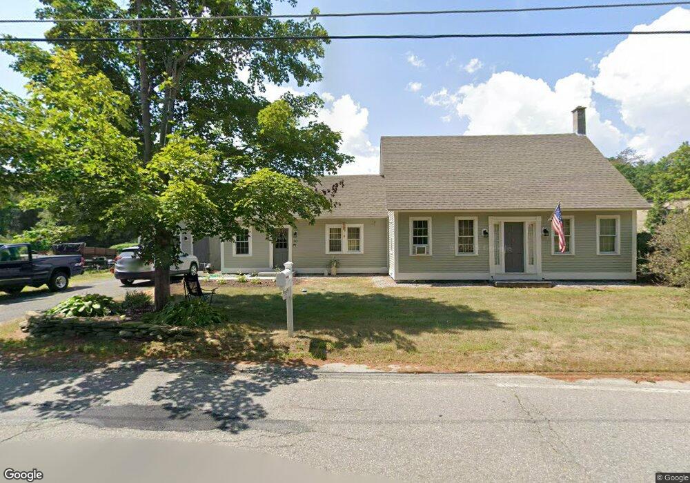
243 Tully Rd Orange, MA 01364
Estimated Value: $281,000 - $367,000
2
Beds
1
Bath
1,242
Sq Ft
$260/Sq Ft
Est. Value
About This Home
This home is located at 243 Tully Rd, Orange, MA 01364 and is currently estimated at $322,357, approximately $259 per square foot. 243 Tully Rd is a home located in Franklin County with nearby schools including Fisher Hill and Ralph C Mahar Regional School.
Ownership History
Date
Name
Owned For
Owner Type
Purchase Details
Closed on
Jun 6, 2024
Sold by
Bartlett Norman E and Bartlett Rhonda C
Bought by
Bartlett Int and Bartlett B
Current Estimated Value
Purchase Details
Closed on
Jul 10, 2023
Sold by
Bartlett Norman
Bought by
Bartlett Norman and Bartlett Rhonda
Purchase Details
Closed on
Nov 23, 2011
Sold by
Bank Of New York Mello
Bought by
Bartlett Norman
Purchase Details
Closed on
Jul 26, 2011
Sold by
Brosseau Albert J and Bank Of New York Mello
Bought by
Bank Of New York Mello
Purchase Details
Closed on
Jun 8, 2007
Sold by
Brosseau Albert J
Bought by
Brosseau Guy L and Brosseau Mona T
Purchase Details
Closed on
Feb 8, 2005
Sold by
Stlawrence Jane M
Bought by
Brosseau Albert John
Home Financials for this Owner
Home Financials are based on the most recent Mortgage that was taken out on this home.
Original Mortgage
$128,000
Interest Rate
5.77%
Mortgage Type
Purchase Money Mortgage
Create a Home Valuation Report for This Property
The Home Valuation Report is an in-depth analysis detailing your home's value as well as a comparison with similar homes in the area
Home Values in the Area
Average Home Value in this Area
Purchase History
| Date | Buyer | Sale Price | Title Company |
|---|---|---|---|
| Bartlett Int | -- | None Available | |
| Bartlett Int | -- | None Available | |
| Bartlett Norman | -- | None Available | |
| Bartlett Norman | -- | None Available | |
| Bartlett Norman | $88,000 | -- | |
| Bank Of New York Mello | $122,310 | -- | |
| Brosseau Guy L | -- | -- | |
| Brosseau Albert John | $160,000 | -- | |
| Bartlett Norman | $88,000 | -- | |
| Bank Of New York Mello | $122,310 | -- | |
| Brosseau Guy L | -- | -- | |
| Brosseau Albert John | $160,000 | -- |
Source: Public Records
Mortgage History
| Date | Status | Borrower | Loan Amount |
|---|---|---|---|
| Previous Owner | Brosseau Albert John | $128,000 |
Source: Public Records
Tax History
| Year | Tax Paid | Tax Assessment Tax Assessment Total Assessment is a certain percentage of the fair market value that is determined by local assessors to be the total taxable value of land and additions on the property. | Land | Improvement |
|---|---|---|---|---|
| 2025 | $41 | $250,700 | $35,300 | $215,400 |
| 2024 | $3,889 | $223,000 | $65,800 | $157,200 |
| 2023 | $3,294 | $183,400 | $61,500 | $121,900 |
| 2022 | $2,799 | $146,400 | $35,300 | $111,100 |
| 2021 | $3,088 | $154,000 | $51,900 | $102,100 |
| 2020 | $3,102 | $152,600 | $51,500 | $101,100 |
| 2019 | $3,013 | $133,800 | $44,800 | $89,000 |
| 2018 | $2,854 | $130,100 | $41,800 | $88,300 |
| 2017 | $2,815 | $132,600 | $41,800 | $90,800 |
| 2016 | $2,680 | $123,500 | $41,800 | $81,700 |
| 2015 | $2,613 | $125,800 | $41,800 | $84,000 |
| 2014 | $2,469 | $125,100 | $42,400 | $82,700 |
Source: Public Records
Map
Nearby Homes
Your Personal Tour Guide
Ask me questions while you tour the home.