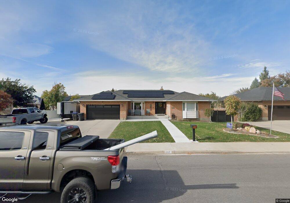
2435 N 1060 E Provo, UT 84604
Rock Canyon NeighborhoodEstimated Value: $715,538 - $916,000
4
Beds
3
Baths
1,821
Sq Ft
$429/Sq Ft
Est. Value
About This Home
This home is located at 2435 N 1060 E, Provo, UT 84604 and is currently estimated at $781,135, approximately $428 per square foot. 2435 N 1060 E is a home located in Utah County with nearby schools including Rock Canyon Elementary School, Centennial Middle School, and Timpview High School.
Ownership History
Date
Name
Owned For
Owner Type
Purchase Details
Closed on
Jan 19, 2016
Sold by
Bateman Michael J and Bateman Chaeryl M
Bought by
Joseph Bateman Cheryl M and Joseph Batemnan Michael
Current Estimated Value
Purchase Details
Closed on
May 29, 2003
Sold by
Bateman Michael J
Bought by
Bateman Michael J and Bateman Cheryl M
Home Financials for this Owner
Home Financials are based on the most recent Mortgage that was taken out on this home.
Original Mortgage
$133,050
Interest Rate
5.75%
Mortgage Type
Purchase Money Mortgage
Purchase Details
Closed on
Oct 19, 2001
Sold by
Bateman Michael
Bought by
Bateman Michael J and Bateman Cheryl M
Home Financials for this Owner
Home Financials are based on the most recent Mortgage that was taken out on this home.
Original Mortgage
$130,000
Interest Rate
6.87%
Create a Home Valuation Report for This Property
The Home Valuation Report is an in-depth analysis detailing your home's value as well as a comparison with similar homes in the area
Home Values in the Area
Average Home Value in this Area
Purchase History
| Date | Buyer | Sale Price | Title Company |
|---|---|---|---|
| Joseph Bateman Cheryl M | -- | None Available | |
| Bateman Michael J | -- | Title West Title Company | |
| Bateman Michael J | -- | Title West Title Company | |
| Bateman Michael J | -- | Title West Title Co | |
| Bateman Michael | -- | Title West Title Co |
Source: Public Records
Mortgage History
| Date | Status | Borrower | Loan Amount |
|---|---|---|---|
| Closed | Bateman Michael J | $133,050 | |
| Closed | Bateman Michael | $130,000 |
Source: Public Records
Tax History
| Year | Tax Paid | Tax Assessment Tax Assessment Total Assessment is a certain percentage of the fair market value that is determined by local assessors to be the total taxable value of land and additions on the property. | Land | Improvement |
|---|---|---|---|---|
| 2025 | $3,288 | $340,780 | -- | -- |
| 2024 | $3,288 | $323,675 | $0 | $0 |
| 2023 | $3,118 | $302,610 | $0 | $0 |
| 2022 | $3,253 | $318,340 | $0 | $0 |
| 2021 | $2,606 | $444,700 | $186,500 | $258,200 |
| 2020 | $2,596 | $415,300 | $162,200 | $253,100 |
| 2019 | $2,343 | $389,800 | $162,200 | $227,600 |
| 2018 | $2,046 | $345,300 | $147,400 | $197,900 |
| 2017 | $1,983 | $183,865 | $0 | $0 |
| 2016 | $2,136 | $184,580 | $0 | $0 |
| 2015 | $2,052 | $179,245 | $0 | $0 |
| 2014 | $1,912 | $174,075 | $0 | $0 |
Source: Public Records
Map
Nearby Homes
- 788 E 2680 N
- 2025 Oak Ln
- 2848 Foothill Dr
- 758 E 3030 N
- 3043 Bannock Dr
- 3129 Cherokee Ln
- 1801 N 650 E
- 1866 N 1450 E
- 2774 N 370 E
- 240 E 2230 N Unit 7
- 3250 Mohawk Ln
- 2091 N 220 E
- 186 E 2100 N
- 360 Sumac Ln
- 1960 N Canyon Rd
- 2735 N Country Club Dr
- 3025 N 250 E
- 1411 N Locust Ln
- 990 Cedar Ave
- 5600 N Canyon Rd
Your Personal Tour Guide
Ask me questions while you tour the home.