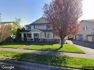
2442 Tolmie Ave Dupont, WA 98327
Estimated Value: $644,000 - $729,000
3
Beds
3
Baths
460
Sq Ft
$1,468/Sq Ft
Est. Value
About This Home
This home is located at 2442 Tolmie Ave, Dupont, WA 98327 and is currently estimated at $675,216, approximately $1,467 per square foot. 2442 Tolmie Ave is a home located in Pierce County with nearby schools including Chloe Clark Elementary School, Saltars Point Elementary School, and Pioneer Middle School.
Ownership History
Date
Name
Owned For
Owner Type
Purchase Details
Closed on
Jan 9, 2018
Sold by
Smith Robert Salguero
Bought by
Smith Mary Ann Lasola
Current Estimated Value
Purchase Details
Closed on
May 5, 2000
Sold by
The Quadrant Corp
Bought by
Smith Robert Salguero and Smith Mary Ann Lasola
Home Financials for this Owner
Home Financials are based on the most recent Mortgage that was taken out on this home.
Original Mortgage
$188,200
Interest Rate
8.25%
Create a Home Valuation Report for This Property
The Home Valuation Report is an in-depth analysis detailing your home's value as well as a comparison with similar homes in the area
Home Values in the Area
Average Home Value in this Area
Purchase History
| Date | Buyer | Sale Price | Title Company |
|---|---|---|---|
| Smith Mary Ann Lasola | -- | None Available | |
| Smith Robert Salguero | $273,690 | Chicago Title |
Source: Public Records
Mortgage History
| Date | Status | Borrower | Loan Amount |
|---|---|---|---|
| Closed | Smith Robert Salguero | $188,200 |
Source: Public Records
Tax History Compared to Growth
Tax History
| Year | Tax Paid | Tax Assessment Tax Assessment Total Assessment is a certain percentage of the fair market value that is determined by local assessors to be the total taxable value of land and additions on the property. | Land | Improvement |
|---|---|---|---|---|
| 2024 | $4,506 | $587,800 | $226,400 | $361,400 |
| 2023 | $4,506 | $560,100 | $220,100 | $340,000 |
| 2022 | $4,488 | $570,400 | $220,100 | $350,300 |
| 2021 | $4,284 | $425,600 | $139,800 | $285,800 |
| 2019 | $3,837 | $388,400 | $116,500 | $271,900 |
| 2018 | $4,174 | $375,400 | $116,500 | $258,900 |
| 2017 | $3,749 | $357,700 | $102,000 | $255,700 |
| 2016 | $3,582 | $324,200 | $86,000 | $238,200 |
| 2014 | $3,442 | $318,300 | $86,000 | $232,300 |
| 2013 | $3,442 | $293,600 | $87,600 | $206,000 |
Source: Public Records
Map
Nearby Homes
- 2198 Palisade Blvd Unit C2
- 2285 McDonald Ave
- 2147 Hammond Ave Unit B10
- 2104 Palisade Blvd Unit B-7
- 2237 McDonald Ave
- 2168 McDonald Ave
- 1456 Rooklidge St
- 2064 McDonald Ave
- 1274 Hudson St
- 2648 Erwin Ave Unit 2648
- 2696 Erwin Ave Unit 2696
- 1936 Palisade Blvd
- 1187 Griggs St Unit 1187
- 2630 Hamilton Ave
- 1484 Kittson St
- 1826 Kennedy Place Unit D-7
- 2546 Mitchell Ave Unit 2
- 1687 Kennedy Place Unit F-2
- 1547 Palisade Blvd Unit 1
- 2010 Garry Oaks Ave Unit A
- 2442 Tolmie Ave
- 2432 Tolmie Ave
- 2452 Tolmie Ave
- 2422 Tolmie Ave
- 2449 Tolmie Ave
- 2459 Tolmie Ave
- 2439 Tolmie Ave
- 2429 Tolmie Ave
- 2419 Tolmie Ave
- 2194 Forrest Place
- 2215 Tolmie St
- 2188 Forrest Place
- 2216 Forrest St
- 2220 Forrest St
- 2182 Forrest Place
- 2221 Tolmie St
- 2222 Forrest St
- 2215 Forrest St
- 2185 Forrest Place
- 2223 Tolmie St