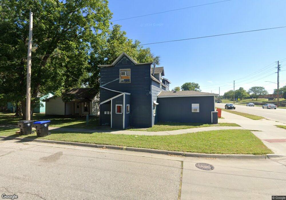
2443 W 1st Ave Topeka, KS 66606
Greater Auburndale NeighborhoodEstimated Value: $79,441 - $102,000
4
Beds
3
Baths
1,330
Sq Ft
$68/Sq Ft
Est. Value
About This Home
This home is located at 2443 W 1st Ave, Topeka, KS 66606 and is currently estimated at $90,721, approximately $68 per square foot. 2443 W 1st Ave is a home located in Shawnee County with nearby schools including Rosenwald Elementary School, Martin Park Elementary School, and Meadows Elementary School.
Ownership History
Date
Name
Owned For
Owner Type
Purchase Details
Closed on
Feb 18, 2022
Sold by
Dean Reed L
Bought by
Jaycat Trading Company Llc
Current Estimated Value
Home Financials for this Owner
Home Financials are based on the most recent Mortgage that was taken out on this home.
Original Mortgage
$80,000
Outstanding Balance
$54,654
Interest Rate
3.69%
Mortgage Type
New Conventional
Estimated Equity
$36,067
Purchase Details
Closed on
Aug 23, 2013
Sold by
Shackelford Lavonne M
Bought by
Carlson Deborah
Purchase Details
Closed on
Apr 24, 2010
Sold by
Shackelford Jim
Bought by
Carlson Deborah
Create a Home Valuation Report for This Property
The Home Valuation Report is an in-depth analysis detailing your home's value as well as a comparison with similar homes in the area
Home Values in the Area
Average Home Value in this Area
Purchase History
| Date | Buyer | Sale Price | Title Company |
|---|---|---|---|
| Jaycat Trading Company Llc | -- | Lawyers Title Of Topeka | |
| Carlson Deborah | -- | None Available | |
| Carlson Deborah | -- | None Available |
Source: Public Records
Mortgage History
| Date | Status | Borrower | Loan Amount |
|---|---|---|---|
| Open | Jaycat Trading Company Llc | $80,000 |
Source: Public Records
Tax History Compared to Growth
Tax History
| Year | Tax Paid | Tax Assessment Tax Assessment Total Assessment is a certain percentage of the fair market value that is determined by local assessors to be the total taxable value of land and additions on the property. | Land | Improvement |
|---|---|---|---|---|
| 2025 | $601 | $4,801 | -- | -- |
| 2023 | $601 | $4,356 | $0 | $0 |
| 2022 | $510 | $3,788 | $0 | $0 |
| 2021 | $560 | $3,788 | $0 | $0 |
| 2020 | $554 | $3,788 | $0 | $0 |
| 2019 | $545 | $3,713 | $0 | $0 |
| 2018 | $529 | $3,605 | $0 | $0 |
| 2017 | $530 | $3,605 | $0 | $0 |
| 2014 | $618 | $4,118 | $0 | $0 |
Source: Public Records
Map
Nearby Homes
- 208 SW MacVicar Ave
- 200 SW Orchard St
- 626 SW Medford Ave
- 618 SW Randolph Ave
- 348 SW Jewell Ave
- 700 SW Roosevelt St
- 614 SW Webster Ave
- 2235 SW Kenilworth Ct
- 0000 SW Elmwood Ave Unit Lots 5,6 Laurel Park
- 1830 SW Willow Ave
- 3005 SW 6th Ave Unit 6th
- 312 SW Elmwood Ave
- 719 SW Jewell Ave
- 734 SW Lindenwood Ave
- 801 SW Wayne Ave
- 808 SW Lindenwood Ave
- 2330 SW Hazelton Ct
- 2204 SW Kensington Ct
- 923 SW High Ave
- 701 SW Watson Ave
- 2443 W 1st Ave Unit A
- 2443 W 1st Ave Unit A
- 2439 W 1st Ave
- 2435 W 1st Ave
- 2431 W 1st Ave
- 103 NW Story St
- 2427 W 1st Ave
- 113 NW Story St
- 2600 SW East Circle Dr S
- 2440 SW 2nd St
- 446 NW The Dr
- 115 NW Story St
- 119 NW Story St
- 440 NW The Dr
- 2407 W 1st Ave
- 135 NW Story St
- 445 NW The Dr
- 2409 W 1st Ave
- 200 SW MacVicar Ave
- 438 NW The Dr