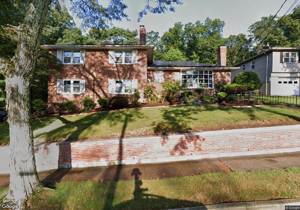
245 Stevenson Rd New Haven, CT 06515
Westville NeighborhoodEstimated Value: $484,651 - $542,000
4
Beds
3
Baths
2,166
Sq Ft
$238/Sq Ft
Est. Value
About This Home
This home is located at 245 Stevenson Rd, New Haven, CT 06515 and is currently estimated at $516,413, approximately $238 per square foot. 245 Stevenson Rd is a home located in New Haven County with nearby schools including Davis Academy for Arts & Design Innovation, Elm City Montessori School, and Hopkins School.
Ownership History
Date
Name
Owned For
Owner Type
Purchase Details
Closed on
Jan 14, 2025
Sold by
Padilla John E
Bought by
Padilla Alexis G
Current Estimated Value
Purchase Details
Closed on
Jun 10, 1997
Sold by
Kazdan Lillian L
Bought by
Padilla John and Padilla Frances
Create a Home Valuation Report for This Property
The Home Valuation Report is an in-depth analysis detailing your home's value as well as a comparison with similar homes in the area
Home Values in the Area
Average Home Value in this Area
Purchase History
| Date | Buyer | Sale Price | Title Company |
|---|---|---|---|
| Padilla Alexis G | -- | None Available | |
| Padilla Alexis G | -- | None Available | |
| Padilla John | $161,000 | -- | |
| Padilla John | $161,000 | -- |
Source: Public Records
Mortgage History
| Date | Status | Borrower | Loan Amount |
|---|---|---|---|
| Previous Owner | Padilla John | $200,000 | |
| Previous Owner | Padilla John | $25,000 | |
| Previous Owner | Padilla John | $178,770 | |
| Previous Owner | Padilla John | $150,000 |
Source: Public Records
Tax History
| Year | Tax Paid | Tax Assessment Tax Assessment Total Assessment is a certain percentage of the fair market value that is determined by local assessors to be the total taxable value of land and additions on the property. | Land | Improvement |
|---|---|---|---|---|
| 2025 | $10,199 | $258,860 | $63,700 | $195,160 |
| 2024 | $9,966 | $258,860 | $63,700 | $195,160 |
| 2023 | $9,630 | $258,860 | $63,700 | $195,160 |
| 2022 | $10,290 | $258,860 | $63,700 | $195,160 |
| 2021 | $8,060 | $183,680 | $41,370 | $142,310 |
| 2020 | $8,060 | $183,680 | $41,370 | $142,310 |
| 2019 | $7,895 | $183,680 | $41,370 | $142,310 |
| 2018 | $7,895 | $183,680 | $41,370 | $142,310 |
| 2017 | $7,105 | $183,680 | $41,370 | $142,310 |
| 2016 | $7,559 | $181,930 | $42,980 | $138,950 |
| 2015 | $7,559 | $181,930 | $42,980 | $138,950 |
| 2014 | $7,559 | $181,930 | $42,980 | $138,950 |
Source: Public Records
Map
Nearby Homes
- 690 Forest Rd Unit 702
- 690 Forest Rd Unit 761
- 690 Forest Rd Unit 501
- 690 Forest Rd Unit 651
- 56 Roger Rd
- 224 Ray Rd
- 21 Richmond Ave
- 119 Westwood Rd
- 125 Lowin Ave
- 51 Fountain Terrace
- 55 Marvel Rd
- 252 Alden Ave
- 50 Morris Ave
- 420 Central Ave
- 143 Fountain St Unit A11
- 50 Maltby Ave
- 107 Glen View Terrace
- 1016 Whalley Ave Unit 6
- 34 Maltby Ave
- 110 Fenwick St
- 235 Stevenson Rd
- 257 Stevenson Rd
- 250 Stevenson Rd
- 240 Stevenson Rd
- 225 Stevenson Rd
- 271 Stevenson Rd
- 230 Stevenson Rd
- 262 Stevenson Rd
- 215 Stevenson Rd
- 270 Stevenson Rd
- 220 Stevenson Rd
- 207 Whittier Rd
- 285 Stevenson Rd
- 284 Stevenson Rd
- 205 Stevenson Rd
- 210 Stevenson Rd
- 220 Whittier Rd
- 175 Whittier Rd
- 16 Spencer Place
- 180 Whittier Rd
Your Personal Tour Guide
Ask me questions while you tour the home.