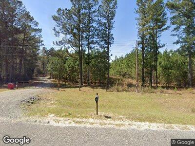
2455 Drone Rd Waynesboro, GA 30830
Estimated Value: $208,000 - $1,183,997
3
Beds
1
Bath
960
Sq Ft
$725/Sq Ft
Est. Value
About This Home
This home is located at 2455 Drone Rd, Waynesboro, GA 30830 and is currently estimated at $695,999, approximately $724 per square foot. 2455 Drone Rd is a home with nearby schools including Burke County High School.
Ownership History
Date
Name
Owned For
Owner Type
Purchase Details
Closed on
Nov 6, 2023
Sold by
Gary L Mcelmurray Living Trust
Bought by
Buckhead Farm Llc
Current Estimated Value
Purchase Details
Closed on
Sep 10, 1996
Sold by
Mcelmurray Gary L
Bought by
Mcelmurray Gary L
Purchase Details
Closed on
Apr 18, 1994
Bought by
Mcelmurray Gary L
Purchase Details
Closed on
Mar 10, 1994
Bought by
Mcelmurray Gary L
Purchase Details
Closed on
Jan 25, 1994
Bought by
Mcelmurray Gary L
Purchase Details
Closed on
Dec 28, 1993
Bought by
Antopolsky In-50 and Antopolsky 34
Create a Home Valuation Report for This Property
The Home Valuation Report is an in-depth analysis detailing your home's value as well as a comparison with similar homes in the area
Home Values in the Area
Average Home Value in this Area
Purchase History
| Date | Buyer | Sale Price | Title Company |
|---|---|---|---|
| Buckhead Farm Llc | -- | -- | |
| Mcelmurray Gary L | -- | -- | |
| Mcelmurray Gary L | $58,500 | -- | |
| Mcelmurray Gary L | $42,000 | -- | |
| Mcelmurray Gary L | $32,400 | -- | |
| Antopolsky In-50 | $19,500 | -- |
Source: Public Records
Tax History Compared to Growth
Tax History
| Year | Tax Paid | Tax Assessment Tax Assessment Total Assessment is a certain percentage of the fair market value that is determined by local assessors to be the total taxable value of land and additions on the property. | Land | Improvement |
|---|---|---|---|---|
| 2024 | $5,041 | $324,359 | $132,179 | $192,180 |
| 2023 | $5,379 | $306,954 | $119,423 | $187,531 |
| 2022 | $1,563 | $125,497 | $111,361 | $14,136 |
| 2021 | $1,514 | $123,122 | $111,361 | $11,761 |
| 2020 | $1,482 | $123,122 | $111,361 | $11,761 |
| 2019 | $1,437 | $137,107 | $126,997 | $10,110 |
| 2018 | $1,403 | $137,107 | $126,997 | $10,110 |
| 2017 | $1,392 | $106,785 | $95,538 | $11,247 |
| 2016 | $1,333 | $106,785 | $95,538 | $11,247 |
| 2015 | $1,348 | $106,729 | $0 | $0 |
| 2014 | -- | $133,374 | $122,182 | $11,192 |
| 2013 | -- | $133,373 | $122,181 | $11,192 |
Source: Public Records
Map
Nearby Homes
- 356 Massey-Doss Rd
- 2051 Gough Rd
- 4286 W Quaker Rd
- 4131 Quaker Rd
- 0 Twin Pines Rd Unit 509137
- 0 Netherland Dr
- 3280 Eden Church Rd
- 1415 Spread Oak Rd
- 1403 Spread Oak Rd
- 685 Bent Knee Rd
- 0 Spread Oak Rd Unit 538280
- 541 Bent Knee Rd
- 0 Wayne St Unit 10453166
- 0-36 Nelson Ct
- 0000 Mcbride St
- 0 Story Mill Rd Unit 539969
- 1163 Fairlane Dr
- 0 Georgia 88
- 1052 Fairlane Dr
- 1197 Jefferson Blvd
