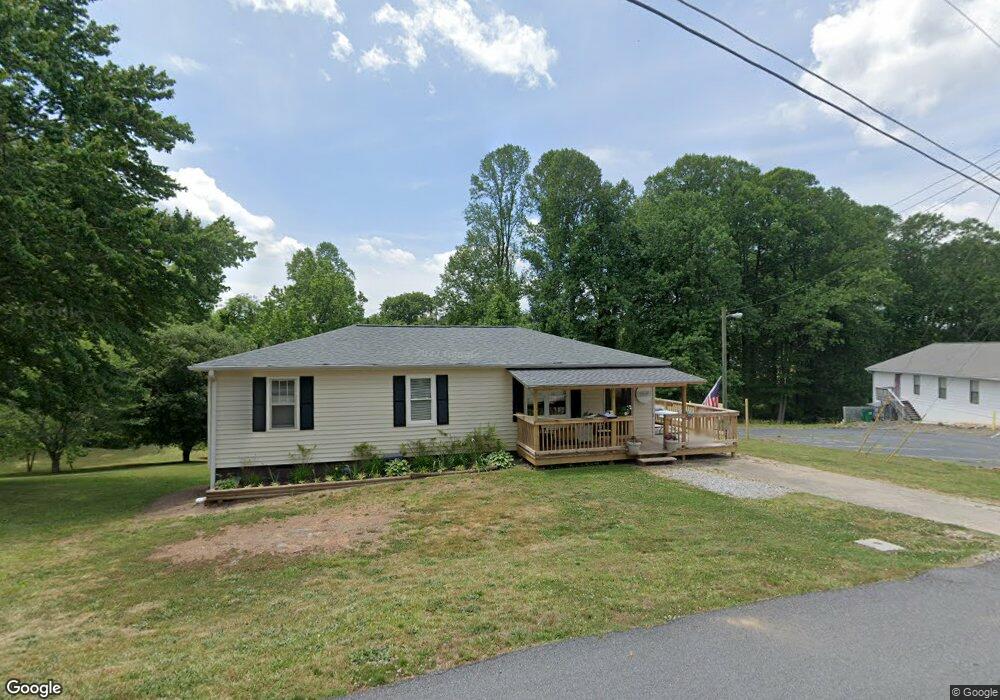
246 Circle Dr Cornelia, GA 30531
Estimated Value: $149,000 - $201,916
3
Beds
3
Baths
1,056
Sq Ft
$174/Sq Ft
Est. Value
About This Home
This home is located at 246 Circle Dr, Cornelia, GA 30531 and is currently estimated at $183,229, approximately $173 per square foot. 246 Circle Dr is a home located in Habersham County with nearby schools including Cornelia Elementary School, Wilbanks Middle School, and Habersham Success Academy.
Ownership History
Date
Name
Owned For
Owner Type
Purchase Details
Closed on
Sep 10, 2020
Sold by
Payne John Kent
Bought by
Dodgins Allison
Current Estimated Value
Home Financials for this Owner
Home Financials are based on the most recent Mortgage that was taken out on this home.
Original Mortgage
$91,666
Outstanding Balance
$81,348
Interest Rate
2.9%
Mortgage Type
New Conventional
Estimated Equity
$101,881
Purchase Details
Closed on
Apr 10, 2015
Sold by
Hammond Lennie Eller
Bought by
Payne John Kent and Payne Amanda Kelley
Home Financials for this Owner
Home Financials are based on the most recent Mortgage that was taken out on this home.
Original Mortgage
$67,900
Interest Rate
3.89%
Purchase Details
Closed on
Oct 12, 2005
Sold by
Addison Keith Edward
Bought by
Hammond Lennie Eller
Create a Home Valuation Report for This Property
The Home Valuation Report is an in-depth analysis detailing your home's value as well as a comparison with similar homes in the area
Home Values in the Area
Average Home Value in this Area
Purchase History
| Date | Buyer | Sale Price | Title Company |
|---|---|---|---|
| Dodgins Allison | $82,000 | -- | |
| Payne John Kent | $69,400 | -- | |
| Hammond Lennie Eller | $75,000 | -- |
Source: Public Records
Mortgage History
| Date | Status | Borrower | Loan Amount |
|---|---|---|---|
| Open | Dodgins Allison | $91,666 | |
| Previous Owner | Payne John Kent | $67,900 | |
| Closed | Hammond Lennie Eller | $0 |
Source: Public Records
Tax History
| Year | Tax Paid | Tax Assessment Tax Assessment Total Assessment is a certain percentage of the fair market value that is determined by local assessors to be the total taxable value of land and additions on the property. | Land | Improvement |
|---|---|---|---|---|
| 2025 | $1,751 | $70,824 | $16,750 | $54,074 |
| 2024 | -- | $55,576 | $9,632 | $45,944 |
| 2023 | $564 | $47,664 | $9,632 | $38,032 |
| 2022 | $940 | $40,360 | $7,704 | $32,656 |
| 2021 | $851 | $32,800 | $6,400 | $26,400 |
| 2020 | $680 | $29,444 | $6,420 | $23,024 |
| 2019 | $681 | $29,444 | $6,420 | $23,024 |
| 2018 | $677 | $29,444 | $6,420 | $23,024 |
| 2017 | $620 | $25,328 | $4,280 | $21,048 |
| 2016 | $600 | $63,320 | $4,280 | $21,048 |
| 2015 | $634 | $61,460 | $4,280 | $20,304 |
| 2014 | $633 | $60,280 | $4,280 | $19,832 |
| 2013 | -- | $24,112 | $4,280 | $19,832 |
Source: Public Records
Map
Nearby Homes
- 592 N Main St
- 795 Wayside St
- 952 Hoyt St NW
- 142 Galloway St
- 112 Galloway St
- 114 Sugar Creek Dr
- 115 Wood St
- 204 Sugar Maple Dr
- 240 Sugar Maple Dr
- 0 Irvin St
- 109 Grove Park Dr
- 167 South St
- 1046 Chase Rd
- 391 Yonah St
- 0 Chase Rd Unit 10658099
- 192 Summit St
- 169 Short Ave
- 0 Furniture Dr Unit 7545752
- 0 Furniture Dr Unit 10484163
- 1576 Chase Rd
Your Personal Tour Guide
Ask me questions while you tour the home.