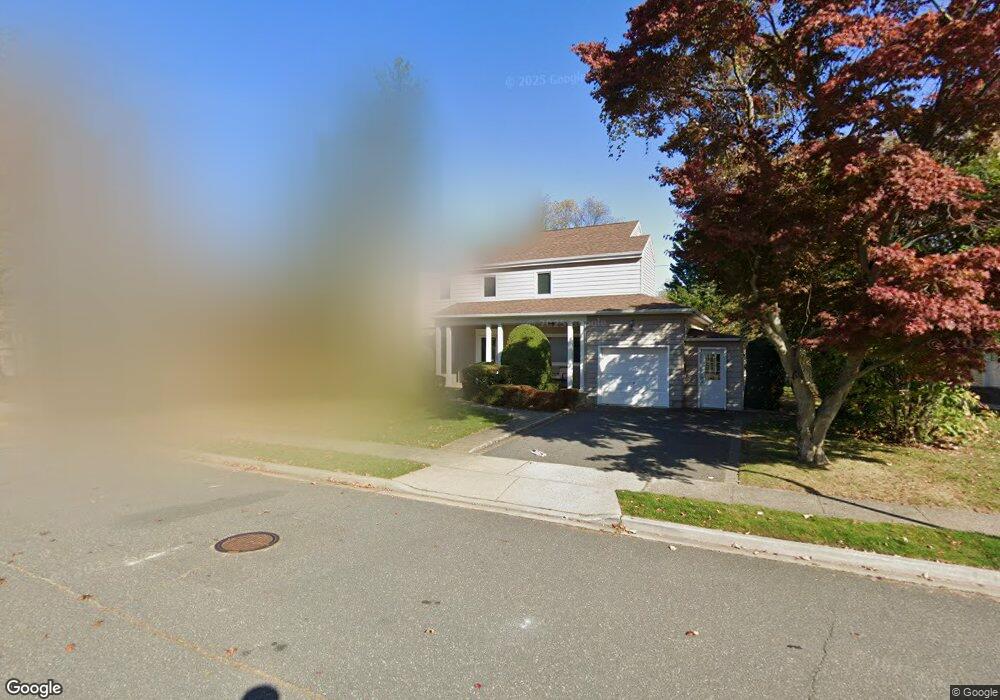
246 Kent Dr Hewlett, NY 11557
Estimated Value: $1,122,000 - $1,162,038
5
Beds
3
Baths
2,603
Sq Ft
$439/Sq Ft
Est. Value
About This Home
This home is located at 246 Kent Dr, Hewlett, NY 11557 and is currently estimated at $1,142,019, approximately $438 per square foot. 246 Kent Dr is a home located in Nassau County with nearby schools including Lynbrook Senior High School, Stella K. Abraham High School For Girls, and Reenas Bais Yaakov.
Ownership History
Date
Name
Owned For
Owner Type
Purchase Details
Closed on
Jul 29, 2021
Sold by
Hirsh Peter and Hirsh Valerie
Bought by
Puri Isha and Chechi Neeraj
Current Estimated Value
Home Financials for this Owner
Home Financials are based on the most recent Mortgage that was taken out on this home.
Original Mortgage
$826,810
Outstanding Balance
$751,826
Interest Rate
2.9%
Mortgage Type
New Conventional
Estimated Equity
$390,193
Create a Home Valuation Report for This Property
The Home Valuation Report is an in-depth analysis detailing your home's value as well as a comparison with similar homes in the area
Home Values in the Area
Average Home Value in this Area
Purchase History
| Date | Buyer | Sale Price | Title Company |
|---|---|---|---|
| Puri Isha | $929,000 | None Available |
Source: Public Records
Mortgage History
| Date | Status | Borrower | Loan Amount |
|---|---|---|---|
| Open | Puri Isha | $826,810 |
Source: Public Records
Tax History Compared to Growth
Tax History
| Year | Tax Paid | Tax Assessment Tax Assessment Total Assessment is a certain percentage of the fair market value that is determined by local assessors to be the total taxable value of land and additions on the property. | Land | Improvement |
|---|---|---|---|---|
| 2025 | $19,953 | $681 | $276 | $405 |
| 2024 | $5,307 | $681 | $276 | $405 |
| 2023 | $17,717 | $681 | $276 | $405 |
| 2022 | $17,717 | $681 | $276 | $405 |
| 2021 | $23,237 | $695 | $281 | $414 |
| 2020 | $14,993 | $787 | $586 | $201 |
| 2019 | $4,265 | $844 | $589 | $255 |
| 2018 | $9,254 | $900 | $0 | $0 |
| 2017 | $9,276 | $956 | $483 | $473 |
| 2016 | $13,630 | $1,242 | $628 | $614 |
| 2015 | $5,276 | $1,242 | $628 | $614 |
| 2014 | $5,276 | $1,242 | $628 | $614 |
| 2013 | $5,152 | $1,242 | $628 | $614 |
Source: Public Records
Map
Nearby Homes
- 262 Channon Rd
- 287 E Rockaway Rd
- 221 Somerset Dr
- 1594 Union Ave
- 1339 Boxwood Dr E
- 1361 Boxwood Dr E
- 33 Prospect Ave
- 19 Dell Dr
- 16A Murdock Rd
- 99 Durland Rd
- 1 Howland Rd
- 171 E Rockaway Rd
- 1560 Pebble Ln
- 1331 Harbor Rd
- 270 Bayberry Dr
- 1302 Azure Place
- 33 Starks Place
- 10 Cail Dr
- 10 Cornell Place
- 10 Bulaire Rd