
Seller's Agent in 2025
John Vrsansky, Jr.
On Target Realty, Inc.
(440) 356-2000
17 in this area
269 Total Sales
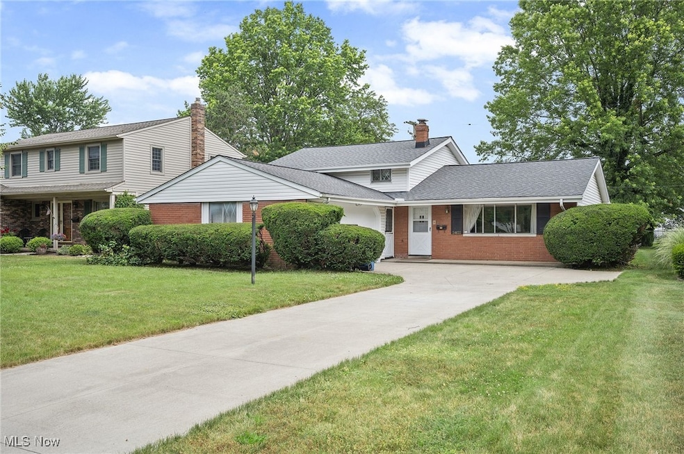

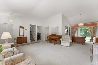


Attractive Split Level on Very Desirable Street .... A Rare Find Original Owner .... Sparkling Clean .... Wide Open Floor Plan .... Spacious Living Room with Cathedral Ceilings ... Inviting Eat-in Kitchen with Appliances .... Huge 23' Family Room .... 14' Utility Room .... Attached Two Car Side Load Garage .... Newer Concrete Driveway .... Newer Roof .... Needs Some Updating yet Priced Very Attractively To Sell .... Location, Location, Location.
Last Agent to Sell the Property
On Target Realty, Inc. Brokerage Email: John@OnTargetRealty.com, 216-849-6775 License #220729 Listed on: 07/03/2025
Co-Listed By
On Target Realty, Inc. Brokerage Email: John@OnTargetRealty.com, 216-849-6775 License #2016000448
| Date | Type | Sale Price | Title Company |
|---|---|---|---|
| Fiduciary Deed | $263,000 | Infinity Title | |
| Interfamily Deed Transfer | -- | Attorney | |
| Deed | -- | -- | |
| Deed | -- | -- |
| Date | Status | Loan Amount | Loan Type |
|---|---|---|---|
| Open | $249,850 | New Conventional |
| Date | Event | Price | List to Sale | Price per Sq Ft |
|---|---|---|---|---|
| 09/02/2025 09/02/25 | Sold | $263,000 | -4.3% | $126 / Sq Ft |
| 07/20/2025 07/20/25 | Pending | -- | -- | -- |
| 07/03/2025 07/03/25 | For Sale | $274,900 | -- | $132 / Sq Ft |
| Year | Tax Paid | Tax Assessment Tax Assessment Total Assessment is a certain percentage of the fair market value that is determined by local assessors to be the total taxable value of land and additions on the property. | Land | Improvement |
|---|---|---|---|---|
| 2025 | $6,230 | $102,060 | $16,380 | $85,680 |
| 2024 | $6,322 | $102,060 | $16,380 | $85,680 |
| 2023 | $4,891 | $69,060 | $15,120 | $53,940 |
| 2022 | $4,900 | $69,055 | $15,120 | $53,935 |
| 2021 | $4,434 | $69,060 | $15,120 | $53,940 |
| 2020 | $3,935 | $56,140 | $12,290 | $43,860 |
| 2019 | $3,829 | $160,400 | $35,100 | $125,300 |
| 2018 | $3,757 | $56,140 | $12,290 | $43,860 |
| 2017 | $3,692 | $50,230 | $10,120 | $40,110 |
| 2016 | $3,659 | $50,230 | $10,120 | $40,110 |
| 2015 | $3,593 | $50,230 | $10,120 | $40,110 |
| 2014 | $3,593 | $49,250 | $9,910 | $39,340 |
Seller's Agent in 2025
John Vrsansky, Jr.
On Target Realty, Inc.
(440) 356-2000
17 in this area
269 Total Sales
W
Seller Co-Listing Agent in 2025
Wayne Plowman
On Target Realty, Inc.
(440) 865-3099
17 in this area
229 Total Sales
Buyer's Agent in 2025
Noura Asaad
Howard Hanna
(440) 454-3551
16 in this area
47 Total Sales
Source: MLS Now
MLS Number: 5132844
APN: 236-07-041
Disclaimer: Certain information contained herein is derived from information provided by parties other than Homes.com. All information provided is deemed reliable, but is not guaranteed to be accurate and should be independently verified.
![]() IDX information is provided exclusively for personal, non-commercial use, and may not be used for any purpose other than to identify prospective properties consumers may be interested in purchasing. Information is deemed reliable but not guaranteed.
IDX information is provided exclusively for personal, non-commercial use, and may not be used for any purpose other than to identify prospective properties consumers may be interested in purchasing. Information is deemed reliable but not guaranteed.
Ask me questions while you tour the home.