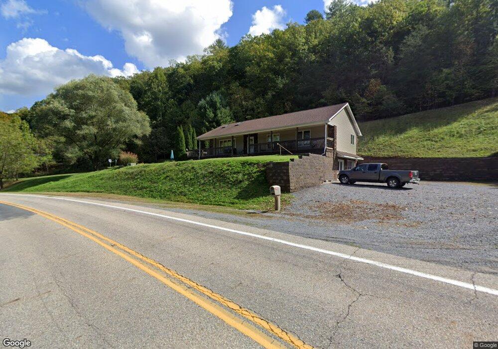
2464 Cowpasture River Hwy Millboro, VA 24460
Estimated Value: $276,000 - $321,238
3
Beds
3
Baths
1,537
Sq Ft
$190/Sq Ft
Est. Value
About This Home
This home is located at 2464 Cowpasture River Hwy, Millboro, VA 24460 and is currently estimated at $292,060, approximately $190 per square foot. 2464 Cowpasture River Hwy is a home located in Bath County with nearby schools including Bath County High School.
Ownership History
Date
Name
Owned For
Owner Type
Purchase Details
Closed on
Dec 12, 2011
Sold by
Wilcher Gary M and Wilcher Diane E
Bought by
Wilcher Gary M and Wilcher Diane E
Current Estimated Value
Purchase Details
Closed on
Oct 20, 2011
Sold by
Citimortgage Inc
Bought by
Wilcher Gary M and Wilcher Diane E
Purchase Details
Closed on
Sep 21, 2010
Sold by
Robertson Daven S and Robertson Patricia L
Bought by
Citimortgage Inc
Create a Home Valuation Report for This Property
The Home Valuation Report is an in-depth analysis detailing your home's value as well as a comparison with similar homes in the area
Home Values in the Area
Average Home Value in this Area
Purchase History
| Date | Buyer | Sale Price | Title Company |
|---|---|---|---|
| Wilcher Gary M | -- | None Available | |
| Wilcher Gary M | $120,000 | None Available | |
| Citimortgage Inc | $105,908 | None Available |
Source: Public Records
Tax History Compared to Growth
Tax History
| Year | Tax Paid | Tax Assessment Tax Assessment Total Assessment is a certain percentage of the fair market value that is determined by local assessors to be the total taxable value of land and additions on the property. | Land | Improvement |
|---|---|---|---|---|
| 2024 | $1,237 | $206,100 | $36,600 | $169,500 |
| 2023 | $1,237 | $206,100 | $36,600 | $169,500 |
| 2022 | $1,134 | $206,100 | $36,600 | $169,500 |
| 2021 | $1,039 | $188,900 | $32,100 | $156,800 |
| 2020 | $1,039 | $188,900 | $32,100 | $156,800 |
| 2019 | $945 | $188,900 | $32,100 | $156,800 |
| 2018 | $945 | $188,900 | $32,100 | $156,800 |
| 2017 | $945 | $188,900 | $32,100 | $156,800 |
| 2016 | -- | $199,000 | $28,600 | $170,400 |
| 2015 | -- | $0 | $0 | $0 |
| 2014 | -- | $0 | $0 | $0 |
| 2012 | -- | $0 | $0 | $0 |
Source: Public Records
Map
Nearby Homes
- 0 Overlook Way Unit 139064
- 0 Overlook Way Unit 914488
- 4801 Nicelytown Rd
- 000 Bennington Ln
- 3114 Longdale Furnace Rd
- 3001 Longdale Furnace Rd
- 3909 Longdale Furnace Rd
- 277 Coffee Pot Rd
- 2835 Airport Rd
- 1508 Jefferson Ave
- 15 Delafield Rd
- 0 Top Rd
- 0 Top Rd Unit LotWP001 20949539
- 0 Grafton St
- 605 Chestnut St
- DR #55 N Forest Trail
- DR Lot #60 N Forest Trail
- DR #50 N Forest Trail
- 0 Spring Hill Rd
- 1221 Hamilton Ave
- 2560 Cowpasture River Hwy
- 2350 Cowpasture River Hwy
- 2610 Cowpasture River Hwy
- 2667 Cowpasture River Hwy
- 2707 Cowpasture River Hwy
- 2297 Cowpasture River Hwy
- 2741 Cowpasture River Hwy
- 2796 Cowpasture River Hwy
- 42 Indian Hill Rd
- 1986 Cowpasture River Hwy
- 39 Indian Hill Rd
- 73 Indian Hill Rd
- 2908 Cowpasture River Hwy
- 123 Indian Hill Rd
- 2948 Cowpasture River Hwy
- 314 Indian Hill Rd
- 314 Indian Hill Rd
- 239 Indian Hill Rd
- 1618 Cowpasture River Hwy
- 1639 Cowpasture River Hwy