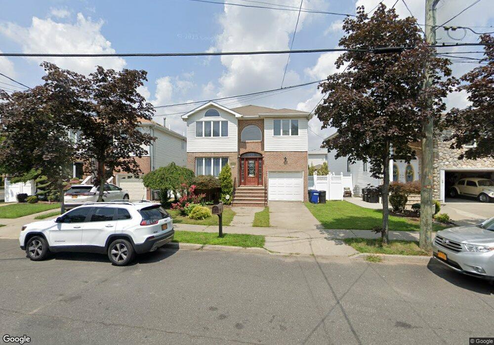
247 McBaine Ave Staten Island, NY 10309
Rossville NeighborhoodEstimated Value: $931,583 - $1,246,000
3
Beds
3
Baths
2,700
Sq Ft
$395/Sq Ft
Est. Value
About This Home
This home is located at 247 McBaine Ave, Staten Island, NY 10309 and is currently estimated at $1,067,396, approximately $395 per square foot. 247 McBaine Ave is a home located in Richmond County with nearby schools including P.S. 56 - The Louis Desario School, Is 34 Tottenville, and Tottenville High School.
Ownership History
Date
Name
Owned For
Owner Type
Purchase Details
Closed on
May 16, 2001
Sold by
Mule Lori
Bought by
Costello Joseph R
Current Estimated Value
Home Financials for this Owner
Home Financials are based on the most recent Mortgage that was taken out on this home.
Original Mortgage
$250,000
Outstanding Balance
$94,179
Interest Rate
7.15%
Estimated Equity
$973,217
Purchase Details
Closed on
Dec 9, 1999
Sold by
Sharrotts Development Corp
Bought by
Mule Lori
Home Financials for this Owner
Home Financials are based on the most recent Mortgage that was taken out on this home.
Original Mortgage
$200,000
Interest Rate
8.31%
Create a Home Valuation Report for This Property
The Home Valuation Report is an in-depth analysis detailing your home's value as well as a comparison with similar homes in the area
Home Values in the Area
Average Home Value in this Area
Purchase History
| Date | Buyer | Sale Price | Title Company |
|---|---|---|---|
| Costello Joseph R | $450,000 | -- | |
| Mule Lori | $381,500 | Commonwealth Land Title Ins |
Source: Public Records
Mortgage History
| Date | Status | Borrower | Loan Amount |
|---|---|---|---|
| Open | Costello Joseph R | $250,000 | |
| Previous Owner | Mule Lori | $200,000 |
Source: Public Records
Tax History Compared to Growth
Tax History
| Year | Tax Paid | Tax Assessment Tax Assessment Total Assessment is a certain percentage of the fair market value that is determined by local assessors to be the total taxable value of land and additions on the property. | Land | Improvement |
|---|---|---|---|---|
| 2025 | $9,745 | $56,940 | $10,650 | $46,290 |
| 2024 | $9,757 | $49,920 | $12,993 | $36,927 |
| 2023 | $10,560 | $53,395 | $10,449 | $42,946 |
| 2022 | $10,074 | $51,900 | $11,460 | $40,440 |
| 2021 | $10,349 | $51,780 | $11,460 | $40,320 |
| 2020 | $10,286 | $54,120 | $11,460 | $42,660 |
| 2019 | $9,573 | $49,320 | $11,460 | $37,860 |
| 2018 | $8,773 | $44,496 | $10,663 | $33,833 |
| 2017 | $8,580 | $43,560 | $11,049 | $32,511 |
| 2016 | $8,122 | $42,180 | $11,460 | $30,720 |
| 2015 | $7,238 | $41,662 | $8,880 | $32,782 |
| 2014 | $7,238 | $39,304 | $9,044 | $30,260 |
Source: Public Records
Map
Nearby Homes
- 243 McBaine Ave
- 251 McBaine Ave
- 239 McBaine Ave
- 244 Mason Blvd
- 240 Mason Blvd
- 248 Mason Blvd
- 236 Mason Blvd
- 235 McBaine Ave
- 232 Mason Blvd
- 250 McBaine Ave
- 254 McBaine Ave
- 231 McBaine Ave
- 228 Mason Blvd
- 242 McBaine Ave
- 308 Winant Ave
- 238 McBaine Ave
- 227 McBaine Ave
- 318 Winant Ave
- 224 Mason Blvd
- 234 McBaine Ave