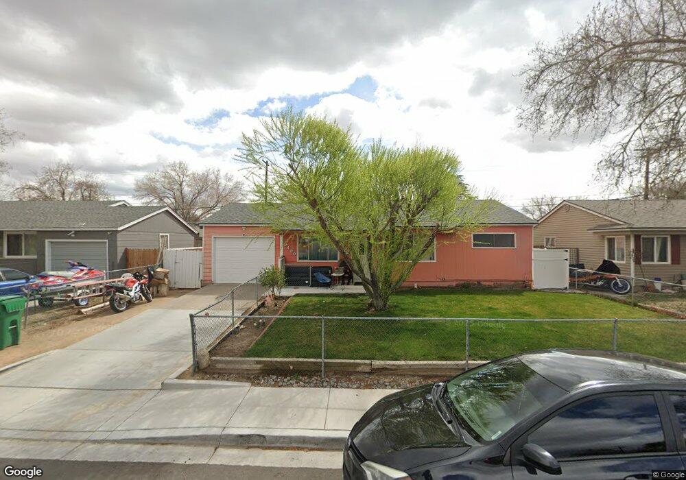
2480 4th St Sparks, NV 89431
McCarran Boulevard-Probasco NeighborhoodEstimated Value: $359,000 - $396,000
3
Beds
1
Bath
1,073
Sq Ft
$352/Sq Ft
Est. Value
About This Home
This home is located at 2480 4th St, Sparks, NV 89431 and is currently estimated at $377,590, approximately $351 per square foot. 2480 4th St is a home located in Washoe County with nearby schools including Florence Drake Elementary School, George L Dilworth Middle School, and Sparks High School.
Ownership History
Date
Name
Owned For
Owner Type
Purchase Details
Closed on
Jan 28, 2009
Sold by
Lopez David
Bought by
Mora Ayala Efigenia
Current Estimated Value
Purchase Details
Closed on
Jan 27, 2009
Sold by
Wachovia Mortgage Fsb
Bought by
Ayala Efigenia Mora
Purchase Details
Closed on
Dec 5, 2008
Sold by
Wood David L and Wood Angela
Bought by
Wachovia Mortgage Fsb and World Savings Bank
Purchase Details
Closed on
Apr 11, 2007
Sold by
Foster Pamela K
Bought by
Wood David L and Wood Angela
Create a Home Valuation Report for This Property
The Home Valuation Report is an in-depth analysis detailing your home's value as well as a comparison with similar homes in the area
Home Values in the Area
Average Home Value in this Area
Purchase History
| Date | Buyer | Sale Price | Title Company |
|---|---|---|---|
| Mora Ayala Efigenia | -- | Stewart Title Of Nevada | |
| Ayala Efigenia Mora | $115,000 | Stewart Title Of Nevada | |
| Wachovia Mortgage Fsb | $127,000 | Ticor Title Of Nevada Inc | |
| Wood David L | $121,500 | First Centennial Title Co |
Source: Public Records
Tax History Compared to Growth
Tax History
| Year | Tax Paid | Tax Assessment Tax Assessment Total Assessment is a certain percentage of the fair market value that is determined by local assessors to be the total taxable value of land and additions on the property. | Land | Improvement |
|---|---|---|---|---|
| 2025 | $679 | $50,104 | $33,565 | $16,539 |
| 2024 | $679 | $46,397 | $30,065 | $16,332 |
| 2023 | $660 | $46,402 | $31,325 | $15,077 |
| 2022 | $641 | $38,438 | $26,180 | $12,258 |
| 2021 | $622 | $29,934 | $17,955 | $11,979 |
| 2020 | $602 | $28,703 | $16,940 | $11,763 |
| 2019 | $584 | $27,044 | $15,890 | $11,154 |
| 2018 | $567 | $22,433 | $11,725 | $10,708 |
| 2017 | $551 | $20,916 | $10,395 | $10,521 |
| 2016 | $537 | $19,801 | $9,345 | $10,456 |
| 2015 | $536 | $18,008 | $7,700 | $10,308 |
| 2014 | $522 | $16,192 | $6,440 | $9,752 |
| 2013 | -- | $13,830 | $4,270 | $9,560 |
Source: Public Records
Map
Nearby Homes
- 119 Devere Way
- 465 Lenwood Dr
- 1940 4th St Unit 20
- 1940 4th St Unit 51
- 1945 4th St Unit 32
- 1945 4th St Unit 33
- 1945 4th St Unit 10
- 10 Sheridan Way
- 780 Emerson Way
- 1703 1st St
- 8 E O St
- 1023 Tyler Way
- 120 E Lenwood Dr
- 3245 Elaine Way
- 1705 9th St
- 1110 Xman Way
- 2865 Patrice Dr
- 1003 Sbragia Way
- 1125 Dodson Way
- 1160 York Way
- 2520 4th St
- 2460 4th St
- 2415 4th St Unit CR-4
- 361 Mcgoldrick Way
- 341 Mcgoldrick Way
- 389 Mcgoldrick Way
- 380 York Way
- 390 York Way
- 381 Mcgoldrick Way
- 2475 4th St
- 2515 4th St
- 360 York Way
- 2455 4th St
- 331 Mcgoldrick Way
- 2535 4th St
- 410 York Way
- 340 York Way
- 321 Mcgoldrick Way Unit 1
- 390 Mcgoldrick Way
- 2555 4th St