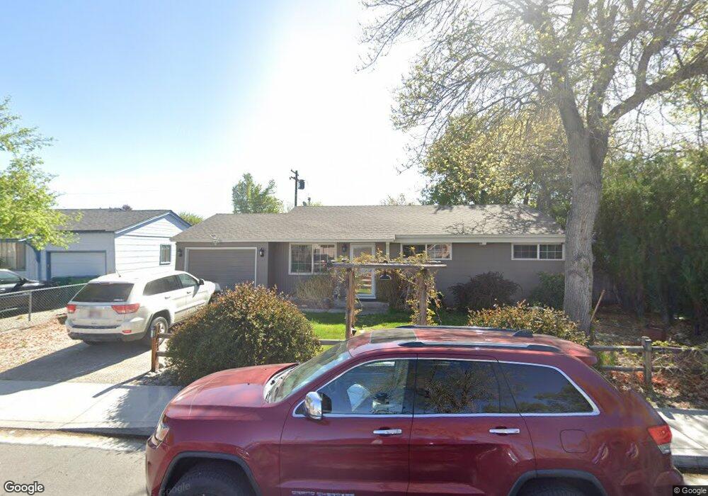
2480 Coppa Way Sparks, NV 89431
McCarran Boulevard-Probasco NeighborhoodEstimated Value: $358,000 - $386,000
3
Beds
1
Bath
1,044
Sq Ft
$351/Sq Ft
Est. Value
About This Home
This home is located at 2480 Coppa Way, Sparks, NV 89431 and is currently estimated at $366,308, approximately $350 per square foot. 2480 Coppa Way is a home located in Washoe County with nearby schools including Florence Drake Elementary School, George L Dilworth Middle School, and Sparks High School.
Ownership History
Date
Name
Owned For
Owner Type
Purchase Details
Closed on
Oct 23, 1997
Sold by
Mcabee Nash Raymond and Mcabee Michele K
Bought by
Mcabee Nash Raymond and Mcabee Michele K
Current Estimated Value
Purchase Details
Closed on
Apr 23, 1997
Sold by
Sanders John M and Sanders Teresa J
Bought by
Mcabee Nash Raymond and Ulrich Michele K
Home Financials for this Owner
Home Financials are based on the most recent Mortgage that was taken out on this home.
Original Mortgage
$96,063
Outstanding Balance
$12,496
Interest Rate
7.96%
Mortgage Type
FHA
Estimated Equity
$353,812
Create a Home Valuation Report for This Property
The Home Valuation Report is an in-depth analysis detailing your home's value as well as a comparison with similar homes in the area
Home Values in the Area
Average Home Value in this Area
Purchase History
| Date | Buyer | Sale Price | Title Company |
|---|---|---|---|
| Mcabee Nash Raymond | -- | -- | |
| Mcabee Nash Raymond | $97,000 | First Centennial Title Co |
Source: Public Records
Mortgage History
| Date | Status | Borrower | Loan Amount |
|---|---|---|---|
| Open | Mcabee Nash Raymond | $96,063 |
Source: Public Records
Tax History Compared to Growth
Tax History
| Year | Tax Paid | Tax Assessment Tax Assessment Total Assessment is a certain percentage of the fair market value that is determined by local assessors to be the total taxable value of land and additions on the property. | Land | Improvement |
|---|---|---|---|---|
| 2025 | $627 | $48,440 | $33,565 | $14,875 |
| 2024 | $610 | $44,735 | $30,065 | $14,670 |
| 2023 | $610 | $44,904 | $31,325 | $13,579 |
| 2022 | $592 | $37,231 | $26,180 | $11,051 |
| 2021 | $575 | $28,734 | $17,955 | $10,779 |
| 2020 | $557 | $27,517 | $16,940 | $10,577 |
| 2019 | $542 | $25,877 | $15,890 | $9,987 |
| 2018 | $526 | $21,314 | $11,725 | $9,589 |
| 2017 | $510 | $19,809 | $10,395 | $9,414 |
| 2016 | $498 | $18,771 | $9,345 | $9,426 |
| 2015 | $374 | $16,945 | $7,700 | $9,245 |
| 2014 | $482 | $15,150 | $6,440 | $8,710 |
| 2013 | -- | $12,765 | $4,270 | $8,495 |
Source: Public Records
Map
Nearby Homes
- 1945 4th St Unit 32
- 1945 4th St Unit 33
- 1945 4th St Unit 10
- 1940 4th St Unit 20
- 1940 4th St Unit 51
- 465 Lenwood Dr
- 1023 Tyler Way
- 119 Devere Way
- 1705 9th St
- 780 Emerson Way
- 1110 Xman Way
- 1003 Sbragia Way
- 1703 1st St
- 1160 York Way
- 1125 Dodson Way
- 10 Sheridan Way
- 8 E O St
- 1124 Sbragia Way
- 1345 Plymouth Way
- 3252 Holman Way