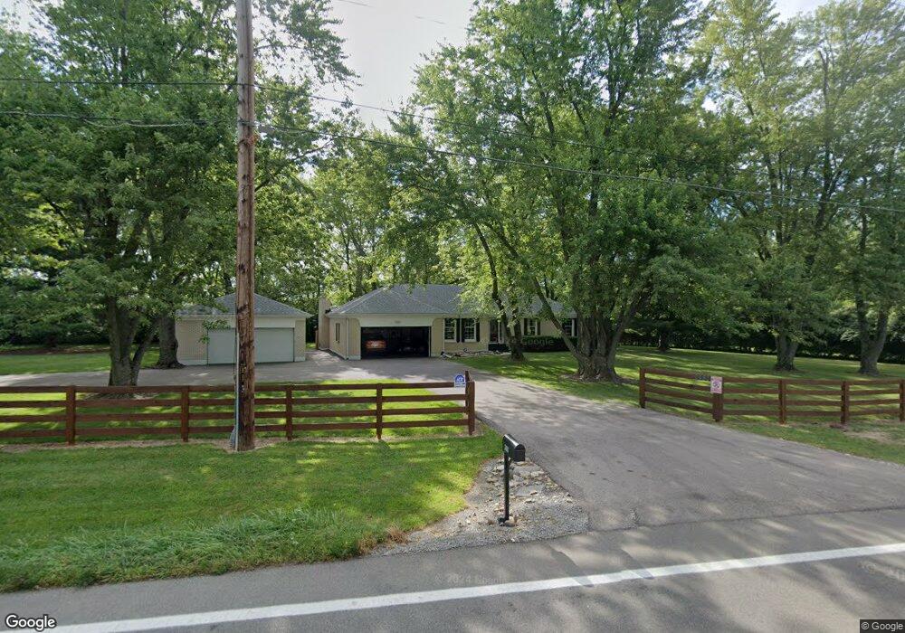
2480 N State Route 741 Franklin, OH 45005
Turtlecreek Township NeighborhoodEstimated Value: $391,000 - $486,000
3
Beds
2
Baths
1,713
Sq Ft
$254/Sq Ft
Est. Value
About This Home
This home is located at 2480 N State Route 741, Franklin, OH 45005 and is currently estimated at $435,215, approximately $254 per square foot. 2480 N State Route 741 is a home located in Warren County with nearby schools including Bowman Primary School, Berry Intermediate School, and Donovan Elementary School.
Ownership History
Date
Name
Owned For
Owner Type
Purchase Details
Closed on
May 10, 2005
Sold by
House William W and House Ruth W
Bought by
House William W and House Ruth W
Current Estimated Value
Purchase Details
Closed on
Apr 27, 1992
Sold by
House & Wm W & Patricia
Bought by
House & William W
Purchase Details
Closed on
Sep 1, 1982
Sold by
Community Savings Associa
Purchase Details
Closed on
Jun 23, 1982
Sold by
Farler Farler and Farler Wm H
Create a Home Valuation Report for This Property
The Home Valuation Report is an in-depth analysis detailing your home's value as well as a comparison with similar homes in the area
Home Values in the Area
Average Home Value in this Area
Purchase History
| Date | Buyer | Sale Price | Title Company |
|---|---|---|---|
| House William W | -- | -- | |
| House & William W | -- | -- | |
| -- | $59,900 | -- | |
| -- | $49,000 | -- |
Source: Public Records
Tax History Compared to Growth
Tax History
| Year | Tax Paid | Tax Assessment Tax Assessment Total Assessment is a certain percentage of the fair market value that is determined by local assessors to be the total taxable value of land and additions on the property. | Land | Improvement |
|---|---|---|---|---|
| 2024 | $5,189 | $127,570 | $40,270 | $87,300 |
| 2023 | $4,587 | $101,913 | $24,650 | $77,262 |
| 2022 | $4,529 | $101,913 | $24,651 | $77,263 |
| 2021 | $4,201 | $101,913 | $24,651 | $77,263 |
| 2020 | $4,100 | $82,856 | $20,041 | $62,815 |
| 2019 | $4,123 | $82,856 | $20,041 | $62,815 |
| 2018 | $3,745 | $82,856 | $20,041 | $62,815 |
| 2017 | $3,728 | $74,242 | $17,584 | $56,658 |
| 2016 | $3,854 | $74,242 | $17,584 | $56,658 |
| 2015 | $3,885 | $74,242 | $17,584 | $56,658 |
| 2014 | $3,708 | $67,670 | $16,630 | $51,040 |
| 2013 | $3,703 | $80,210 | $18,450 | $61,760 |
Source: Public Records
Map
Nearby Homes
- 3122 N State Route 741
- 1782 Ohio 741
- 3085 Ohio 122
- 3600 Yellow Finch Way
- 2266 N St Rt 123
- 2266 N St Rt 123 Unit Site D
- 2266 Ohio 123
- 2266 Ohio 123 Unit Site C
- 2266 Ohio 123 Unit Site A
- 2266 Ohio 123 Unit Site B
- 0 Ohio 122
- 1801 Kirby Rd
- 3138 Patrick Ct
- 1369 New England Way
- 3562 Aniston Ct
- 4284 Yellow Prairie Dr
- 4289 Yellow Prairie Dr
- 3617 Garrett Dr
- 0 Aniston Ct Unit 1824950
- 0 Aniston Ct
- 2392 N State Route 741
- 2370 N State Route 741
- 2379 S State Route 741
- 3 Ohio 741 Unit 3
- 2 Ohio 741 Unit 2
- 3340 Oak Ridge Dr
- 3364 Oak Ridge Dr
- 2294 N State Route 741
- 3384 Oak Ridge Dr
- 3339 Oak Ridge Dr
- 3404 Oak Ridge Dr
- 3426 Oak Ridge Dr
- 3375 Oak Ridge Dr
- 2259 N State Route 741
- 2259 N St Rt 741
- 3450 Oak Ridge Dr
- 3450 Oak Creek Dr
- 3405 Oak Ridge Dr
- 3474 Oak Ridge Dr
- 2252 N State Route 741