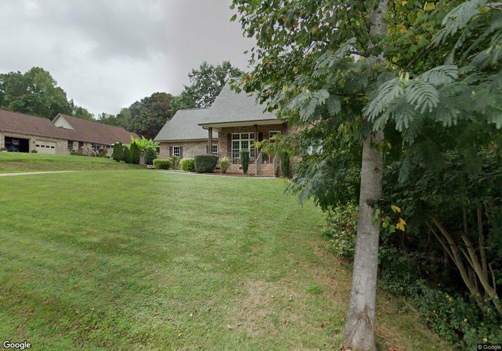
249 Lariat Dr Lincolnton, NC 28092
Estimated Value: $414,000 - $496,000
3
Beds
3
Baths
2,228
Sq Ft
$206/Sq Ft
Est. Value
About This Home
This home is located at 249 Lariat Dr, Lincolnton, NC 28092 and is currently estimated at $459,822, approximately $206 per square foot. 249 Lariat Dr is a home with nearby schools including North Lincoln Middle School and North Lincoln High School.
Ownership History
Date
Name
Owned For
Owner Type
Purchase Details
Closed on
Aug 5, 2015
Sold by
Buddy Caldwell Builders Inc
Bought by
Hewitt Wesley S and Hewitt Jenna C
Current Estimated Value
Home Financials for this Owner
Home Financials are based on the most recent Mortgage that was taken out on this home.
Original Mortgage
$180,000
Outstanding Balance
$141,617
Interest Rate
4.04%
Mortgage Type
Construction
Estimated Equity
$318,205
Purchase Details
Closed on
Jun 5, 1995
Bought by
Pound William Gregory and Kendra Byn
Create a Home Valuation Report for This Property
The Home Valuation Report is an in-depth analysis detailing your home's value as well as a comparison with similar homes in the area
Home Values in the Area
Average Home Value in this Area
Purchase History
| Date | Buyer | Sale Price | Title Company |
|---|---|---|---|
| Hewitt Wesley S | -- | None Available | |
| Pound William Gregory | $10,000 | -- |
Source: Public Records
Mortgage History
| Date | Status | Borrower | Loan Amount |
|---|---|---|---|
| Open | Hewitt Wesley S | $180,000 |
Source: Public Records
Tax History Compared to Growth
Tax History
| Year | Tax Paid | Tax Assessment Tax Assessment Total Assessment is a certain percentage of the fair market value that is determined by local assessors to be the total taxable value of land and additions on the property. | Land | Improvement |
|---|---|---|---|---|
| 2025 | $2,833 | $431,620 | $43,000 | $388,620 |
| 2024 | $2,813 | $431,620 | $43,000 | $388,620 |
| 2023 | $2,808 | $431,620 | $43,000 | $388,620 |
| 2022 | $2,247 | $286,602 | $34,000 | $252,602 |
| 2021 | $2,247 | $286,602 | $34,000 | $252,602 |
| 2020 | $2,075 | $286,602 | $34,000 | $252,602 |
| 2019 | $2,018 | $286,602 | $34,000 | $252,602 |
| 2018 | $1,884 | $249,059 | $32,000 | $217,059 |
| 2017 | $1,686 | $237,120 | $32,000 | $205,120 |
| 2016 | $1,686 | $237,120 | $32,000 | $205,120 |
| 2015 | $127 | $18,200 | $18,200 | $0 |
| 2014 | $180 | $26,000 | $26,000 | $0 |
Source: Public Records
Map
Nearby Homes
- 370 Sherrill Farm Rd
- 2583 Wallace Acres Ln
- 2914 Weatherfield Dr
- 2911 Weatherfield Dr
- 2983 Tavistock Ln
- 2794 N Carolina Highway 150
- 2984 N Carolina 27
- lot 22 Weatherwood Dr Unit 22
- 000 Curveview Rd
- 2546 N Carolina Highway 150
- 3478 N Carolina Highway 150
- 3164 Andrew Link Rd
- 1471 Arden Dr
- 1335 Huckleberry Dr
- 1404 Old Mill Rd
- 741 Sunridge Dr
- 2202 Carpenter Farms Dr
- 575 Hill Rd
- 00 Mcalister Rd
- 1818 Maple Ln
- 3193 Fair Oaks Dr
- 3193 Fair Oaks Dr Unit 9
- 3183 Fair Oaks Dr
- 250 Lariat Dr
- 226 Lariat Dr
- 213 Lariat Dr
- 266 Lariat Dr
- 266 Lariat Dr Unit 26,27
- 279 Lariat Dr
- 3184 Fair Oaks Dr
- 210 Lariat Dr
- 276 Lariat Dr
- 3405 Asbury Church Rd
- 195 Lariat Dr
- 293 Lariat Dr
- 286 Lariat Dr
- 196 Lariat Dr
- 296 Lariat Dr
- 303 Lariat Dr
- 186 Lariat Dr