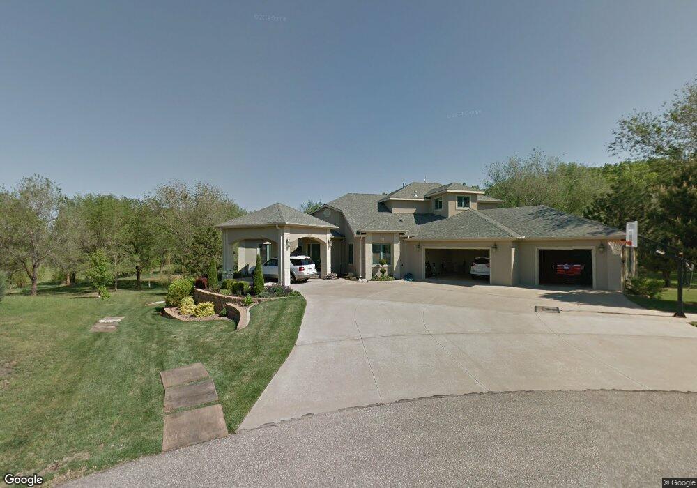
2490 Maclean Cir Salina, KS 67401
Estimated Value: $531,000 - $838,000
3
Beds
5
Baths
4,253
Sq Ft
$176/Sq Ft
Est. Value
About This Home
This home is located at 2490 Maclean Cir, Salina, KS 67401 and is currently estimated at $746,654, approximately $175 per square foot. 2490 Maclean Cir is a home located in Saline County with nearby schools including Coronado Elementary School, Salina South Middle School, and Salina High School South.
Ownership History
Date
Name
Owned For
Owner Type
Purchase Details
Closed on
Dec 22, 2012
Sold by
Simpson Martin J and Simpson Doreen L
Bought by
Simpson Doreen L and Simpson Martin J
Current Estimated Value
Home Financials for this Owner
Home Financials are based on the most recent Mortgage that was taken out on this home.
Original Mortgage
$275,550
Interest Rate
3.34%
Create a Home Valuation Report for This Property
The Home Valuation Report is an in-depth analysis detailing your home's value as well as a comparison with similar homes in the area
Home Values in the Area
Average Home Value in this Area
Purchase History
| Date | Buyer | Sale Price | Title Company |
|---|---|---|---|
| Simpson Doreen L | -- | None | |
| Simpson Martin J | -- | None |
Source: Public Records
Mortgage History
| Date | Status | Borrower | Loan Amount |
|---|---|---|---|
| Previous Owner | Simpson Martin J | $275,550 |
Source: Public Records
Tax History Compared to Growth
Tax History
| Year | Tax Paid | Tax Assessment Tax Assessment Total Assessment is a certain percentage of the fair market value that is determined by local assessors to be the total taxable value of land and additions on the property. | Land | Improvement |
|---|---|---|---|---|
| 2025 | $13,460 | $94,896 | $6,832 | $88,064 |
| 2024 | $13,460 | $97,957 | $6,453 | $91,504 |
| 2023 | $13,460 | $93,369 | $7,488 | $85,881 |
| 2022 | $12,541 | $93,081 | $6,092 | $86,989 |
| 2021 | $12,245 | $88,619 | $6,115 | $82,504 |
| 2020 | $12,100 | $86,549 | $6,687 | $79,862 |
| 2019 | $10,418 | $81,547 | $6,584 | $74,963 |
| 2018 | $10,365 | $75,256 | $5,724 | $69,532 |
| 2017 | $0 | $69,437 | $5,783 | $63,654 |
| 2016 | $0 | $70,276 | $5,369 | $64,907 |
| 2015 | -- | $70,265 | $5,310 | $64,955 |
| 2013 | -- | $0 | $0 | $0 |
Source: Public Records
Map
Nearby Homes
- 2466 Glencoe Cir
- 00000 Glencoe Cir
- 2475 Dundee Ln
- 2515 Dundee Ln
- 2508 Berwick Cir
- 2608 Aberdeen Ln
- 2615 Aberdeen Ln
- 2001 Wheatland Cir
- 2000 Wheatland Cir
- 2006 Wheatland Cir
- 2230 Huntwood Dr
- 2231 Huntwood Dr
- 1968 Wheatland Valley Dr
- 1933 Wheatland Valley Dr
- 2157 Redhawk Ln
- 2736 Tim Rogers Ln
- 00000 Longfield Dr
- 00000 Overlook Dr
- 2005 Overlook Dr
- 2015 Overlook Dr
- 2494 Maclean Cir
- 2498 Maclean Cir
- 2474 Glencoe Cir
- 2470 Glencoe Creek
- 2466 Glencoe Creek
- 2506 MacKensie Cir
- 2510 MacKensie Cir
- 2474 St Andrew Ln
- 2474 Saint Andrews Ln
- 2474 St Andrews Ln
- 2514 MacKensie Cir
- 2522 Mackenzie Cir
- 2522 MacKensie Cir
- 2241 E Magnolia Rd
- 2514 Berwick Cir
- 2518 Mackenzie Cir
- 2514 Berwick Cir
- 2518 MacKensie Cir
- 2465 Saint Andrews Ln
- 2512 Berwick Cir