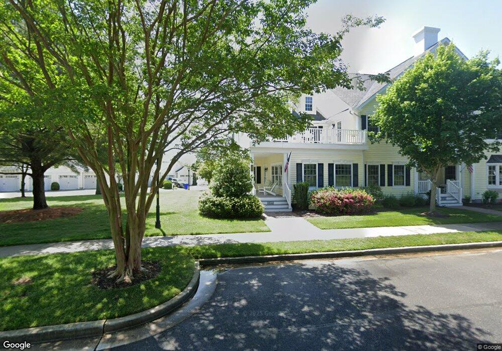
24976 Pot Bunker Way Millsboro, DE 19966
Estimated Value: $292,000 - $553,933
3
Beds
--
Bath
2,466
Sq Ft
$162/Sq Ft
Est. Value
About This Home
This home is located at 24976 Pot Bunker Way, Millsboro, DE 19966 and is currently estimated at $398,733, approximately $161 per square foot. 24976 Pot Bunker Way is a home located in Sussex County with nearby schools including Long Neck Elementary School, Millsboro Middle School, and Sussex Central High School.
Ownership History
Date
Name
Owned For
Owner Type
Purchase Details
Closed on
Feb 25, 2025
Sold by
Sutton Peter Charles and Sutton Susan Lynne
Bought by
Sutton Peter Charles and Sutton Susan Lynne
Current Estimated Value
Purchase Details
Closed on
Sep 13, 2024
Sold by
Putnam Carolyn C and Putnam Carolyn A
Bought by
Sutton Peter Charles and Sutton Susan Lynne
Home Financials for this Owner
Home Financials are based on the most recent Mortgage that was taken out on this home.
Original Mortgage
$414,000
Interest Rate
6.73%
Mortgage Type
New Conventional
Create a Home Valuation Report for This Property
The Home Valuation Report is an in-depth analysis detailing your home's value as well as a comparison with similar homes in the area
Home Values in the Area
Average Home Value in this Area
Purchase History
| Date | Buyer | Sale Price | Title Company |
|---|---|---|---|
| Sutton Peter Charles | -- | None Listed On Document | |
| Sutton Peter Charles | -- | None Listed On Document | |
| Sutton Peter Charles | $460,000 | None Listed On Document |
Source: Public Records
Mortgage History
| Date | Status | Borrower | Loan Amount |
|---|---|---|---|
| Previous Owner | Sutton Peter Charles | $414,000 |
Source: Public Records
Tax History Compared to Growth
Tax History
| Year | Tax Paid | Tax Assessment Tax Assessment Total Assessment is a certain percentage of the fair market value that is determined by local assessors to be the total taxable value of land and additions on the property. | Land | Improvement |
|---|---|---|---|---|
| 2025 | $746 | $38,600 | $0 | $38,600 |
| 2024 | $1,127 | $38,600 | $0 | $38,600 |
| 2023 | $1,137 | $38,600 | $0 | $38,600 |
| 2022 | $1,111 | $38,600 | $0 | $38,600 |
| 2021 | $1,163 | $38,600 | $0 | $38,600 |
| 2020 | $1,093 | $38,600 | $0 | $38,600 |
| 2019 | $1,086 | $38,600 | $0 | $38,600 |
| 2018 | $1,101 | $39,050 | $0 | $0 |
| 2017 | $1,113 | $39,050 | $0 | $0 |
| 2016 | $836 | $39,050 | $0 | $0 |
| 2015 | $876 | $39,050 | $0 | $0 |
| 2014 | $856 | $39,050 | $0 | $0 |
Source: Public Records
Map
Nearby Homes
- 32447 Back Nine Way Unit 3765
- 24960 Pot Bunker Way
- 32431 Back Nine Way Unit 3761
- 24934 Pot Bunker Way Unit 3716
- 32377 Back Nine Way Unit 3747
- 24965 Crooked Stick Way Unit 4343
- 32667 Back Nine Way Unit 3857
- 32675 Back Nine Way Unit 3858
- Lot 1 Canal Drive Extended
- 32701 Back Nine Way
- 32575 Friendship Dr
- 24322 Canal Dr
- 24644 Dogwood Ln
- 24494 Blue Blvd
- 32383 Austin Dr
- 32575 Long Iron Way Unit 3214
- 32554 Long Spoon Way Unit 3141
- 36628 4038 Dew Way
- 205 Long Neck Cir
- 32291 Dogleg Way Unit 4021
- 24976 Pot Bunker Way Unit 3704
- 24974 Pot Bunker Way Unit 3705
- 24974 Pot Bunker Way
- 24972 Pot Bunker Way Unit 3706
- 24966 Pot Bunker Way
- 24966 Pot Bunker Way Unit 3708
- 24968 Pot Bunker Way Unit 3707
- 32449 Back Nine Way Unit 3766
- 32451 Back Nine Way Unit 3767
- 32451 Back Nine Way
- 32447 Back Nine Way Unit 376
- 24960 Pot Bunker Way Unit 3709
- 32437 Back Nine Way Unit 3763
- 32455 Back Nine Way Unit 3768
- 32443 Back Nine Way Unit 3764
- 32435 Back Nine Way Unit 3762
- 24954 Pot Bunker Way
- 24954 Pot Bunker Way Unit 3711
- 25008 Pot Bunker Way Unit 3701
- 24956 Pot Bunker Way Unit 3710