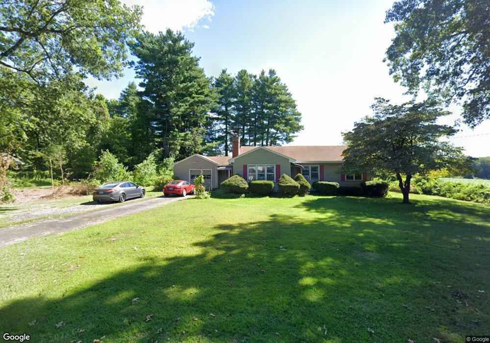
25 Charnley Rd Enfield, CT 06082
Estimated Value: $273,000 - $315,000
2
Beds
1
Bath
1,065
Sq Ft
$277/Sq Ft
Est. Value
About This Home
This home is located at 25 Charnley Rd, Enfield, CT 06082 and is currently estimated at $294,728, approximately $276 per square foot. 25 Charnley Rd is a home located in Hartford County with nearby schools including Nathan Hale Elementary School, Edgar H. Parkman School, and John F. Kennedy Middle School.
Ownership History
Date
Name
Owned For
Owner Type
Purchase Details
Closed on
Dec 14, 2021
Sold by
Framarin Anthony and Framarin Dylan
Bought by
Framarin Anthony
Current Estimated Value
Home Financials for this Owner
Home Financials are based on the most recent Mortgage that was taken out on this home.
Original Mortgage
$118,706
Outstanding Balance
$106,214
Interest Rate
3.11%
Mortgage Type
Stand Alone Refi Refinance Of Original Loan
Estimated Equity
$188,514
Purchase Details
Closed on
Jul 14, 2015
Sold by
Kertanis George F and Reardon Phyliss
Bought by
Framarin Dylan and Framarin Anthony
Home Financials for this Owner
Home Financials are based on the most recent Mortgage that was taken out on this home.
Original Mortgage
$128,250
Interest Rate
3.87%
Create a Home Valuation Report for This Property
The Home Valuation Report is an in-depth analysis detailing your home's value as well as a comparison with similar homes in the area
Home Values in the Area
Average Home Value in this Area
Purchase History
| Date | Buyer | Sale Price | Title Company |
|---|---|---|---|
| Framarin Anthony | -- | None Available | |
| Framarin Anthony | -- | None Available | |
| Framarin Dylan | $135,000 | -- | |
| Framarin Dylan | $135,000 | -- |
Source: Public Records
Mortgage History
| Date | Status | Borrower | Loan Amount |
|---|---|---|---|
| Open | Framarin Anthony | $118,706 | |
| Closed | Framarin Anthony | $118,706 | |
| Previous Owner | Framarin Dylan | $128,250 |
Source: Public Records
Tax History Compared to Growth
Tax History
| Year | Tax Paid | Tax Assessment Tax Assessment Total Assessment is a certain percentage of the fair market value that is determined by local assessors to be the total taxable value of land and additions on the property. | Land | Improvement |
|---|---|---|---|---|
| 2025 | $5,075 | $144,600 | $64,900 | $79,700 |
| 2024 | $4,889 | $144,600 | $64,900 | $79,700 |
| 2023 | $4,853 | $144,600 | $64,900 | $79,700 |
| 2022 | $4,467 | $144,600 | $64,900 | $79,700 |
| 2021 | $4,383 | $116,650 | $55,960 | $60,690 |
| 2020 | $4,353 | $116,650 | $55,960 | $60,690 |
| 2019 | $4,348 | $116,650 | $55,960 | $60,690 |
| 2018 | $4,231 | $116,650 | $55,960 | $60,690 |
| 2017 | $3,975 | $116,650 | $55,960 | $60,690 |
| 2016 | $3,841 | $115,140 | $55,960 | $59,180 |
| 2015 | $3,724 | $115,140 | $55,960 | $59,180 |
| 2014 | $3,630 | $115,140 | $55,960 | $59,180 |
Source: Public Records
Map
Nearby Homes
- 12 Salerno Dr
- 70 Fletcher Rd
- 45 Monroe Rd
- 34 Ridgefield Rd
- 11 Northfield Rd
- 138 Main St
- 5 Michael Dr
- 7 East Rd
- 287 Hazard Ave
- 155 Sheridan Rd
- 31 Meade Ln
- 56 N Maple St
- 12 South Rd
- 2 Meacham Dr Unit 2
- 4 Copley Cir
- 23 Clear St
- 233 Post Office Rd
- 83 Oldefield Farms Unit 83
- 85 Oldefield Farms Unit 85
- 3 Avon Street Extension