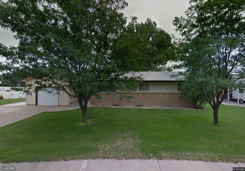
25 Elm St Montrose, CO 81401
Estimated Value: $326,000 - $394,000
2
Beds
2
Baths
1,305
Sq Ft
$269/Sq Ft
Est. Value
About This Home
This home is located at 25 Elm St, Montrose, CO 81401 and is currently estimated at $351,621, approximately $269 per square foot. 25 Elm St is a home located in Montrose County with nearby schools including Pomona Elementary School, Columbine Middle School, and Montrose High School.
Ownership History
Date
Name
Owned For
Owner Type
Purchase Details
Closed on
Dec 20, 2019
Sold by
Stitt Donald W and Estate Of Dan L Stitt
Bought by
Stitt Donald W
Current Estimated Value
Purchase Details
Closed on
Jul 17, 2019
Sold by
Stitt Donald W and Estate Of Dan C Stitt
Bought by
Stitt Donald W
Purchase Details
Closed on
Jul 15, 2019
Sold by
Deedent Danlstitt
Bought by
Stitt Donlad W
Purchase Details
Closed on
Jan 10, 2019
Sold by
Stitt Donald W
Bought by
Davault Jason and Davault Monica A
Home Financials for this Owner
Home Financials are based on the most recent Mortgage that was taken out on this home.
Original Mortgage
$223,100
Interest Rate
3.6%
Mortgage Type
New Conventional
Purchase Details
Closed on
May 9, 1973
Sold by
Weber Stanley E and Weber Helen M
Bought by
Stitt Dan L and Stitt Lois J
Create a Home Valuation Report for This Property
The Home Valuation Report is an in-depth analysis detailing your home's value as well as a comparison with similar homes in the area
Home Values in the Area
Average Home Value in this Area
Purchase History
| Date | Buyer | Sale Price | Title Company |
|---|---|---|---|
| Stitt Donald W | -- | None Available | |
| Stitt Donald W | -- | None Available | |
| Stitt Donlad W | -- | None Available | |
| Davault Jason | $230,000 | Colorado Ttl & Closing Svcs | |
| Stitt Dan L | $28,500 | -- |
Source: Public Records
Mortgage History
| Date | Status | Borrower | Loan Amount |
|---|---|---|---|
| Previous Owner | Davault Jason | $223,100 |
Source: Public Records
Tax History Compared to Growth
Tax History
| Year | Tax Paid | Tax Assessment Tax Assessment Total Assessment is a certain percentage of the fair market value that is determined by local assessors to be the total taxable value of land and additions on the property. | Land | Improvement |
|---|---|---|---|---|
| 2024 | $1,286 | $18,060 | $3,060 | $15,000 |
| 2023 | $1,286 | $22,550 | $3,820 | $18,730 |
| 2022 | $1,233 | $17,920 | $2,780 | $15,140 |
| 2021 | $1,271 | $18,440 | $2,860 | $15,580 |
| 2020 | $1,000 | $14,910 | $2,470 | $12,440 |
| 2019 | $1,007 | $14,910 | $2,470 | $12,440 |
| 2018 | $824 | $11,910 | $1,990 | $9,920 |
| 2017 | $409 | $11,910 | $1,990 | $9,920 |
| 2016 | $384 | $11,360 | $2,010 | $9,350 |
| 2015 | $753 | $11,360 | $2,010 | $9,350 |
| 2014 | $546 | $8,800 | $2,010 | $6,790 |
Source: Public Records
Map
Nearby Homes
- 119 Akard Ave
- TBD Montrose Dr Site C
- 103 Duncan Place
- 122 Spruce Dr
- 535 S 11th St Unit 5
- 1413 Chatam Dr
- 902 S Mesa Ave
- Lot 5 TBD E Oak Grove Rd
- TBD Lot 1 E Oak Grove Rd
- 0 E Oak Grove Rd
- Tract A & 3 E Oak Grove Rd
- Tract 3 E Oak Grove Rd
- Tract A, 3 Lot2 E Oak Grove Rd
- Tract A E Oak Grove Rd
- Lot 2 E Oak Grove Rd
- 612 & 616 S 6th
- 909 S 10th St
- 23 S 5th St
- 814 S 7th St
- 2036 Scarborough Way Unit J