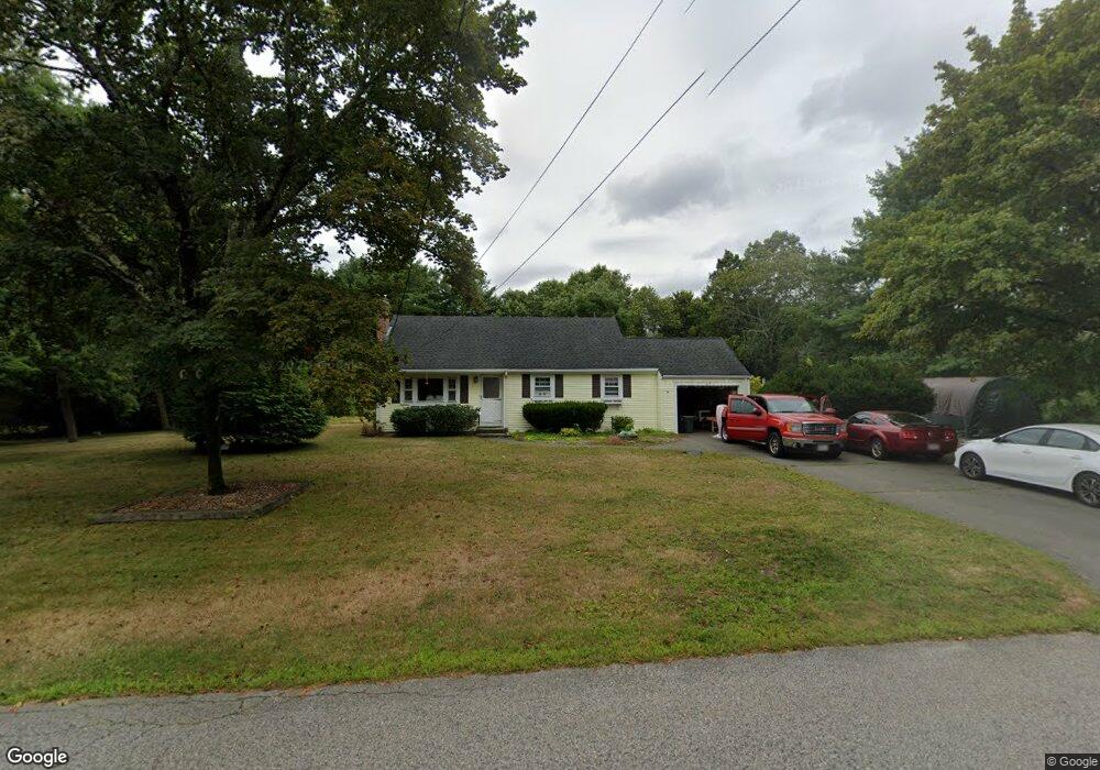
25 King Phillip Ln Hanover, MA 02339
Estimated Value: $545,644 - $704,000
3
Beds
1
Bath
1,060
Sq Ft
$574/Sq Ft
Est. Value
About This Home
This home is located at 25 King Phillip Ln, Hanover, MA 02339 and is currently estimated at $608,661, approximately $574 per square foot. 25 King Phillip Ln is a home located in Plymouth County with nearby schools including Hanover High School and Cardinal Cushing Centers.
Ownership History
Date
Name
Owned For
Owner Type
Purchase Details
Closed on
Jan 16, 2020
Sold by
Hotton Jeanne M
Bought by
Nickerson Jeanne M
Current Estimated Value
Purchase Details
Closed on
Feb 2, 2004
Sold by
Hotton Richard E and Hotton Jeanne Marie
Bought by
Hotton Jeanne Marie and Hotton Jeanne M
Purchase Details
Closed on
Oct 3, 1994
Sold by
Irvine Paul W and Irvine Joanne C
Bought by
Hotton Richard E and Hotton Jeanne M
Create a Home Valuation Report for This Property
The Home Valuation Report is an in-depth analysis detailing your home's value as well as a comparison with similar homes in the area
Home Values in the Area
Average Home Value in this Area
Purchase History
| Date | Buyer | Sale Price | Title Company |
|---|---|---|---|
| Nickerson Jeanne M | -- | None Available | |
| Hotton Jeanne Marie | -- | -- | |
| Hotton Richard E | $130,000 | -- |
Source: Public Records
Mortgage History
| Date | Status | Borrower | Loan Amount |
|---|---|---|---|
| Previous Owner | Hotton Richard E | $363,598 | |
| Previous Owner | Hotton Richard E | $359,665 | |
| Previous Owner | Hotton Richard E | $320,000 |
Source: Public Records
Tax History Compared to Growth
Tax History
| Year | Tax Paid | Tax Assessment Tax Assessment Total Assessment is a certain percentage of the fair market value that is determined by local assessors to be the total taxable value of land and additions on the property. | Land | Improvement |
|---|---|---|---|---|
| 2025 | $6,160 | $498,800 | $269,600 | $229,200 |
| 2024 | $6,405 | $498,800 | $269,600 | $229,200 |
| 2023 | $6,351 | $470,800 | $245,100 | $225,700 |
| 2022 | $6,134 | $402,200 | $232,800 | $169,400 |
| 2021 | $6,049 | $370,400 | $189,400 | $181,000 |
| 2020 | $5,981 | $366,700 | $200,500 | $166,200 |
| 2019 | $5,725 | $348,900 | $200,500 | $148,400 |
| 2018 | $5,560 | $341,500 | $200,500 | $141,000 |
| 2017 | $5,503 | $333,100 | $199,500 | $133,600 |
| 2016 | $5,191 | $307,900 | $181,400 | $126,500 |
| 2015 | $4,758 | $294,600 | $168,100 | $126,500 |
Source: Public Records
Map
Nearby Homes
- 154 Winter St
- 67 School St
- 553 Center St
- 436 Center St
- 41 Gail Rd
- 21 King St
- 51 Cervelli Farm Dr
- 37 Dr
- 23 Cervelli Farm Dr
- 38 Cervelli Farm Dr
- 9 Cervelli Farm Dr
- 1251 Broadway
- 250 Center St
- 116 Spring Meadow Ln
- 8 Old Farm Rd
- Lot 22 Adams Cir
- 842 E Washington St
- 114 Graham Hill Dr
- 418 E Washington St
- 15 Elm Place
- 37 King Phillip Ln
- 52 Tecumseh Dr
- 18 Sequoya Ln
- 30 Sequoya Ln
- 32 King Phillip Ln
- 20 King Phillip Ln
- 49 King Phillip Ln
- 42 King Phillip Ln
- 32 Tecumseh Dr
- 44 Sequoya Ln
- 45 Tecumseh Dr
- 57 Tecumseh Dr
- 56 King Phillip Ln
- 91 Myrtle St
- 19 Sequoya Ln
- 61 King Phillip Ln
- 103 Myrtle St
- 31 Sequoya Ln
- 86 Tecumseh Dr
- 69 Tecumseh Dr