
Seller's Agent in 2026
Sharon Fox
Carl Guild & Associates
(860) 805-6917
1 in this area
42 Total Sales
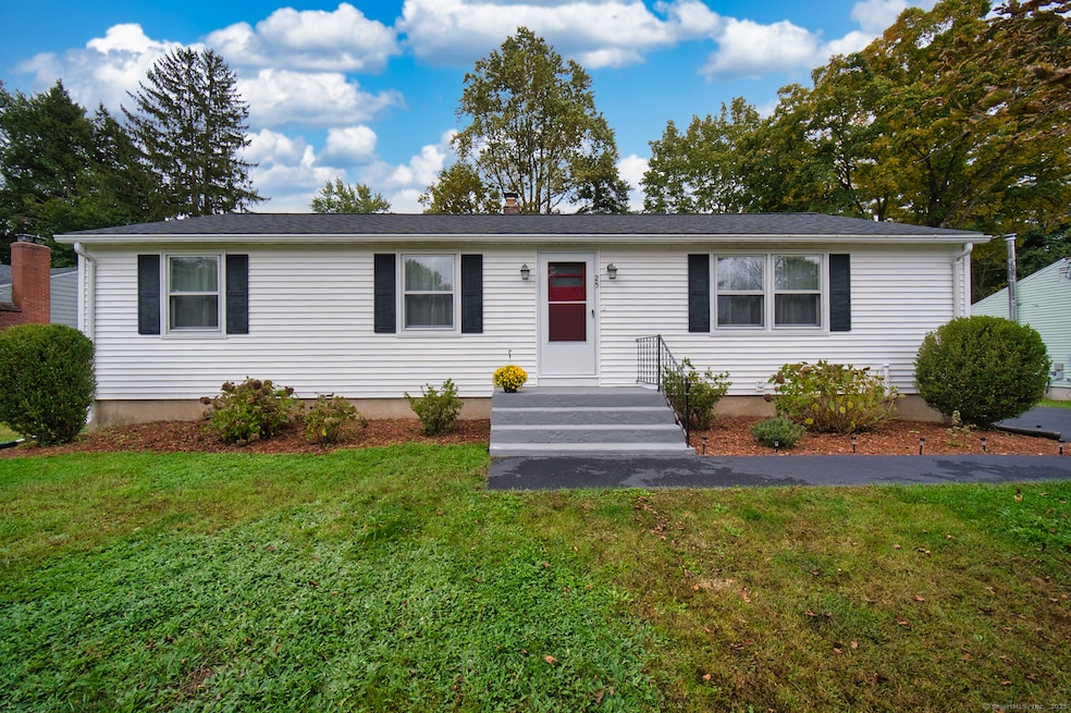
MOVE-IN READY 3-BEDROOM RANCH with SOLAR SAVINGS! Tucked in on a quiet Cul-de-sac, this turnkey Windsor home features hardwood floors, a sunny three-season porch, and leased solar panels for near-zero electric bills. Main-level living offers 1,152 sq ft with an additional 518 sq ft in the partially finished basement - perfect for a home office, gym, or playroom. Freshly painted common areas flow seamlessly to the porch for relaxing or entertaining. The spacious .26-acre lot provides room for gardening, outdoor living, or future expansion. MAJOR UPDATES: Main roof (2020), garage roof (2024), replaced and widened driveway (2022, sealed 2024), new garage opener/keypad (2024), bulkhead (2022), and LVP wall planks in hallway (2025). Appliances stay, to include refrigerator, stove, microwave, dishwasher, washer, and dryer. Located in a quiet, established neighborhood, this home is perfect for first-time buyers, down-sizers, or anyone seeking single-level living with additional space in the basement. With turnkey condition and energy-efficient solar panels, this Windsor gem won't last long. Schedule your showing today!
Last Agent to Sell the Property
Carl Guild & Associates Brokerage Email: sharonfoxrealtor1@gmail.com License #RES.0774349 Listed on: 10/14/2025
| Date | Type | Sale Price | Title Company |
|---|---|---|---|
| Warranty Deed | $328,000 | -- | |
| Warranty Deed | $190,000 | -- |
| Date | Status | Loan Amount | Loan Type |
|---|---|---|---|
| Open | $278,800 | Purchase Money Mortgage | |
| Previous Owner | $178,310 | Unknown | |
| Previous Owner | $186,550 | Purchase Money Mortgage |
| Date | Event | Price | List to Sale | Price per Sq Ft |
|---|---|---|---|---|
| 02/20/2026 02/20/26 | Sold | $328,000 | +2.5% | $196 / Sq Ft |
| 02/20/2026 02/20/26 | Pending | -- | -- | -- |
| 11/06/2025 11/06/25 | Price Changed | $319,900 | -4.5% | $192 / Sq Ft |
| 10/14/2025 10/14/25 | For Sale | $334,900 | -- | $201 / Sq Ft |
| Year | Tax Paid | Tax Assessment Tax Assessment Total Assessment is a certain percentage of the fair market value that is determined by local assessors to be the total taxable value of land and additions on the property. | Land | Improvement |
|---|---|---|---|---|
| 2025 | $5,224 | $183,610 | $60,200 | $123,410 |
| 2024 | $5,567 | $183,610 | $60,200 | $123,410 |
| 2023 | $4,100 | $122,010 | $47,110 | $74,900 |
| 2022 | $4,059 | $122,010 | $47,110 | $74,900 |
| 2021 | $4,059 | $122,010 | $47,110 | $74,900 |
| 2020 | $4,040 | $122,010 | $47,110 | $74,900 |
| 2019 | $3,951 | $122,010 | $47,110 | $74,900 |
| 2018 | $3,835 | $116,340 | $47,110 | $69,230 |
| 2017 | $3,775 | $116,340 | $47,110 | $69,230 |
| 2016 | $3,667 | $116,340 | $47,110 | $69,230 |
| 2015 | $3,597 | $116,340 | $47,110 | $69,230 |
| 2014 | $3,545 | $116,340 | $47,110 | $69,230 |
Seller's Agent in 2026
Sharon Fox
Carl Guild & Associates
(860) 805-6917
1 in this area
42 Total Sales
Buyer's Agent in 2026
Roger Veilleux
William Raveis Real Estate
(860) 250-3252
1 in this area
158 Total Sales
Source: SmartMLS
MLS Number: 24133215
APN: WIND-000067-000044-000034A
Disclaimer: Certain information contained herein is derived from information provided by parties other than Homes.com. All information provided is deemed reliable, but is not guaranteed to be accurate and should be independently verified.
![]() IDX information is provided exclusively for personal, non-commercial use, and may not be used for any purpose other than to identify prospective properties consumers may be interested in purchasing. Information is deemed reliable but not guaranteed.
IDX information is provided exclusively for personal, non-commercial use, and may not be used for any purpose other than to identify prospective properties consumers may be interested in purchasing. Information is deemed reliable but not guaranteed.
Ask me questions while you tour the home.