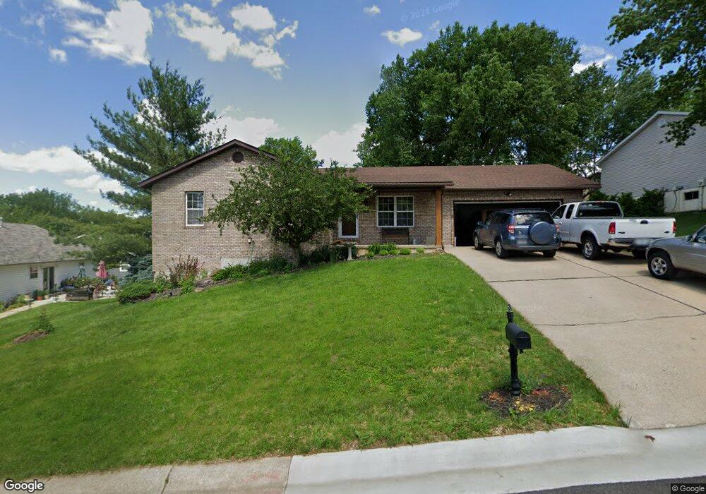
25 Mike Alan Dr Washington, MO 63090
Estimated Value: $284,092 - $329,000
3
Beds
1
Bath
1,332
Sq Ft
$227/Sq Ft
Est. Value
About This Home
This home is located at 25 Mike Alan Dr, Washington, MO 63090 and is currently estimated at $302,364, approximately $227 per square foot. 25 Mike Alan Dr is a home located in Franklin County with nearby schools including Washington High School, Our Lady of Lourdes Catholic School, and St. Francis Borgia Catholic School.
Ownership History
Date
Name
Owned For
Owner Type
Purchase Details
Closed on
Oct 3, 2016
Sold by
Thompson Brenda and Thompson Lynn
Bought by
Thompson Brenda and Thompson Lynn
Current Estimated Value
Purchase Details
Closed on
Apr 19, 2013
Sold by
Thompson Lynn E and Thompson Brenda S
Bought by
Thompson Lynn E and Thompson Brenda S
Purchase Details
Closed on
Jun 14, 2006
Sold by
Thompson Lynn E and Thompson Sharon L
Bought by
Thompson Lynn E
Home Financials for this Owner
Home Financials are based on the most recent Mortgage that was taken out on this home.
Original Mortgage
$120,000
Outstanding Balance
$77,109
Interest Rate
6.56%
Mortgage Type
New Conventional
Estimated Equity
$225,255
Create a Home Valuation Report for This Property
The Home Valuation Report is an in-depth analysis detailing your home's value as well as a comparison with similar homes in the area
Home Values in the Area
Average Home Value in this Area
Purchase History
| Date | Buyer | Sale Price | Title Company |
|---|---|---|---|
| Thompson Brenda | -- | -- | |
| Thompson Lynn E | -- | -- | |
| Thompson Lynn E | -- | None Available |
Source: Public Records
Mortgage History
| Date | Status | Borrower | Loan Amount |
|---|---|---|---|
| Open | Thompson Lynn E | $120,000 |
Source: Public Records
Tax History
| Year | Tax Paid | Tax Assessment Tax Assessment Total Assessment is a certain percentage of the fair market value that is determined by local assessors to be the total taxable value of land and additions on the property. | Land | Improvement |
|---|---|---|---|---|
| 2025 | $2,034 | $41,179 | $0 | $0 |
| 2024 | $2,034 | $35,908 | $0 | $0 |
| 2023 | $2,038 | $35,908 | $0 | $0 |
| 2022 | $2,125 | $37,394 | $0 | $0 |
| 2021 | $2,119 | $37,394 | $0 | $0 |
| 2020 | $1,981 | $33,659 | $0 | $0 |
| 2019 | $1,977 | $33,659 | $0 | $0 |
| 2018 | $1,929 | $32,598 | $0 | $0 |
| 2017 | $1,926 | $32,598 | $0 | $0 |
| 2016 | $1,726 | $29,718 | $0 | $0 |
| 2015 | $1,725 | $29,718 | $0 | $0 |
| 2014 | $1,739 | $29,982 | $0 | $0 |
Source: Public Records
Map
Nearby Homes
- 106 Tina Dr
- 136 Monticello Dr
- 3317 Timber Creek Dr Unit 195 STB
- 3321 Timber Creek Dr Unit 196 STB
- 2995 Halls Green Dr
- 176 Hank's Close Ct Unit 176 STB
- 187 Hank's Close Ct Unit 187 STB
- 2321 Hank's Close Rd Unit 185 STB
- 167 Pellin's Unit 167 STB
- 183 Hank's Close Rd Unit 183 STB
- 192 Timber Crest Rd Unit 192 STB
- 3313 Timber Creek Dr Unit 194 STB
- 179 Hank's Close Unit 179 STB
- 1205 Caroline Dr
- 2316 Hank's Close Unit 175 STB
- 173 Hank's Close Unit 173 STB
- 2304 Pellin's Ct Unit 148 STB
- 180 Hank's Close Unit 180 STB
- 1800 E 9th St
- 162 Pellin's Ct Unit 162 STB
Your Personal Tour Guide
Ask me questions while you tour the home.