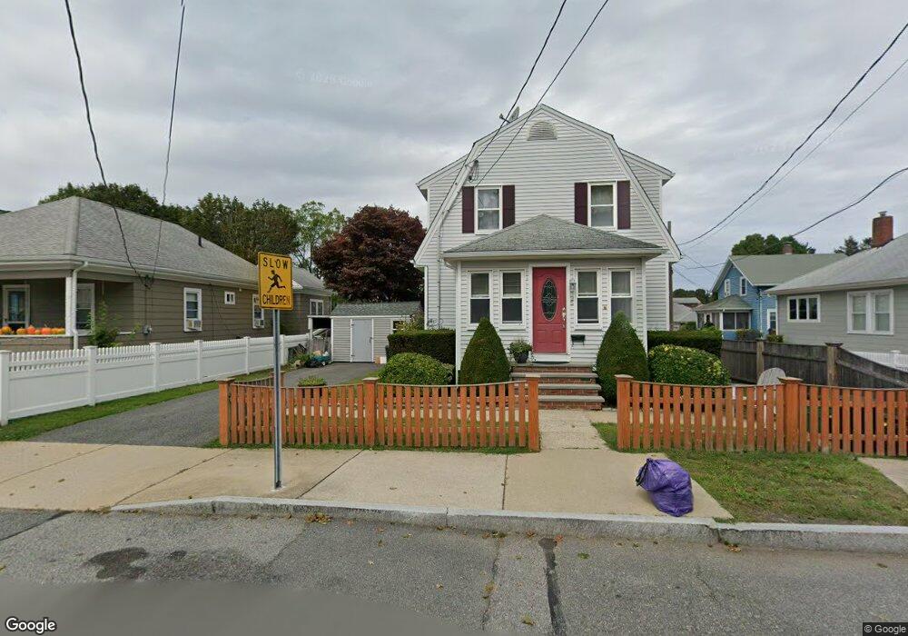
25 Riverside Ave Gloucester, MA 01930
Central Gloucester NeighborhoodEstimated Value: $593,368 - $656,000
3
Beds
2
Baths
1,300
Sq Ft
$479/Sq Ft
Est. Value
About This Home
This home is located at 25 Riverside Ave, Gloucester, MA 01930 and is currently estimated at $622,092, approximately $478 per square foot. 25 Riverside Ave is a home located in Essex County with nearby schools including Plum Cove School, Ralph B O'maley Middle School, and Gloucester High School.
Ownership History
Date
Name
Owned For
Owner Type
Purchase Details
Closed on
Jun 30, 2003
Sold by
Hogan Daniel F and Hogan Patricia R
Bought by
Scola Michael D
Current Estimated Value
Purchase Details
Closed on
May 30, 2000
Sold by
Kittredge Gayle H Est
Bought by
Hickey William Peter
Purchase Details
Closed on
Sep 6, 1996
Sold by
Quinn Joan M
Bought by
Stratton Charlotte A
Create a Home Valuation Report for This Property
The Home Valuation Report is an in-depth analysis detailing your home's value as well as a comparison with similar homes in the area
Home Values in the Area
Average Home Value in this Area
Purchase History
| Date | Buyer | Sale Price | Title Company |
|---|---|---|---|
| Scola Michael D | $285,000 | -- | |
| Hickey William Peter | $170,000 | -- | |
| Stratton Charlotte A | $125,000 | -- |
Source: Public Records
Mortgage History
| Date | Status | Borrower | Loan Amount |
|---|---|---|---|
| Open | Stratton Charlotte A | $242,200 | |
| Closed | Stratton Charlotte A | $268,000 |
Source: Public Records
Tax History
| Year | Tax Paid | Tax Assessment Tax Assessment Total Assessment is a certain percentage of the fair market value that is determined by local assessors to be the total taxable value of land and additions on the property. | Land | Improvement |
|---|---|---|---|---|
| 2025 | $4,813 | $495,200 | $142,900 | $352,300 |
| 2024 | $4,752 | $488,400 | $136,100 | $352,300 |
| 2023 | $4,545 | $429,200 | $121,500 | $307,700 |
| 2022 | $4,401 | $375,200 | $105,700 | $269,500 |
| 2021 | $4,247 | $341,400 | $96,100 | $245,300 |
| 2020 | $4,142 | $335,900 | $96,100 | $239,800 |
| 2019 | $3,916 | $308,600 | $96,100 | $212,500 |
| 2018 | $3,726 | $288,200 | $96,100 | $192,100 |
| 2017 | $3,610 | $273,700 | $91,500 | $182,200 |
| 2016 | $3,491 | $256,500 | $95,500 | $161,000 |
| 2015 | $3,458 | $253,300 | $95,500 | $157,800 |
Source: Public Records
Map
Nearby Homes
- 3 Rockland St
- 15 Harvard St
- 6 Monroe Ct
- 120 Washington St
- 98 Maplewood Ave
- 13 Leslie o Johnson Rd
- 20 Beacon St
- 20 Beacon St Unit 2
- 20 Beacon St Unit 1
- 8 Mystic Ave
- 13 Mystic Ave
- 9 Cleveland Place
- 12 Arthur St
- 33 Maplewood Ave Unit 310
- 145 Essex Ave Unit 402
- 113 Pleasant St
- 40 Sargent St
- 33 Middle St
- 35 Middle St Unit 4
- 50 Warner St
- 27 Riverside Ave
- 23 Riverside Ave
- 6 Hayward Rd
- 29 Riverside Ave
- 1 Hayward Rd
- 26 Riverside Ave
- 9 Gloucester Ave
- 21 Riverside Ave
- 22 Riverside Ave
- 24 Riverside Ave
- 31 Riverside Ave
- 7 Gloucester Ave
- 28 Riverside Ave
- 45 Riverside Ave
- 11 Gloucester Ave
- 5 Gloucester Ave
- 30 Riverside Ave
- 13 Gloucester Ave
- 17 Riverside Ave
- 15 Gloucester Ave
Your Personal Tour Guide
Ask me questions while you tour the home.