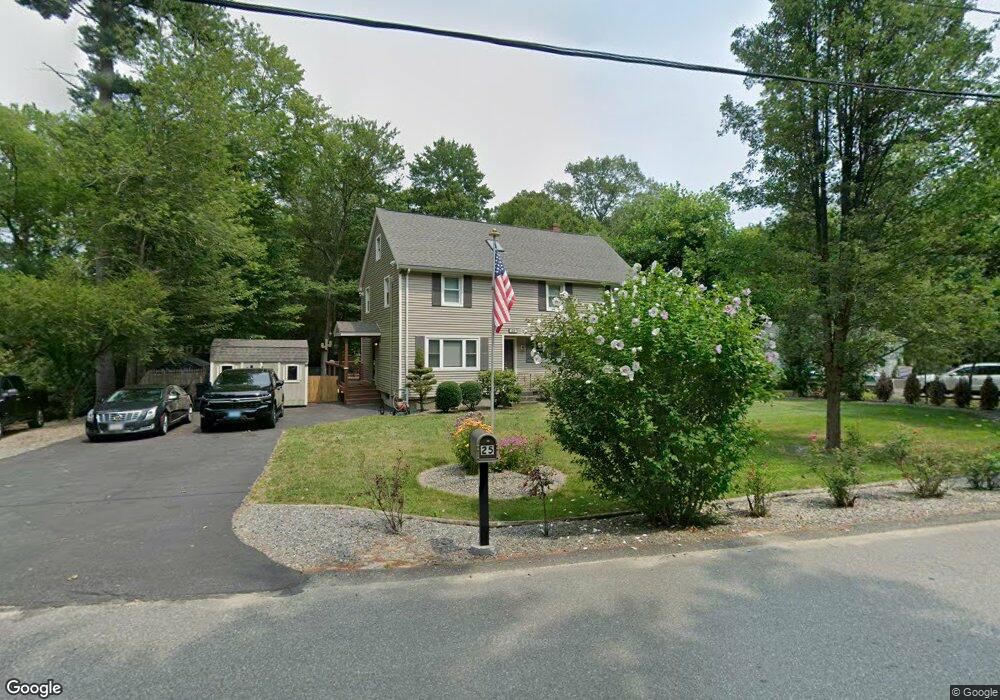
25 Smith St Norton, MA 02766
Estimated Value: $632,818 - $728,000
3
Beds
2
Baths
2,080
Sq Ft
$327/Sq Ft
Est. Value
About This Home
This home is located at 25 Smith St, Norton, MA 02766 and is currently estimated at $679,705, approximately $326 per square foot. 25 Smith St is a home located in Bristol County with nearby schools including J.C. Solmonese Elementary School, Henri A. Yelle Elementary School, and Norton Middle School.
Ownership History
Date
Name
Owned For
Owner Type
Purchase Details
Closed on
Nov 6, 2000
Sold by
Walker Robin L and Walker Andrew J
Bought by
Simmons Shawn R and Simmons Rebekah
Current Estimated Value
Home Financials for this Owner
Home Financials are based on the most recent Mortgage that was taken out on this home.
Original Mortgage
$155,200
Interest Rate
7.83%
Mortgage Type
Purchase Money Mortgage
Purchase Details
Closed on
Apr 23, 1993
Sold by
Ohearn John H and Ohearn Ellen J Rubin
Bought by
Walker Andrew J and Walker Robin L
Create a Home Valuation Report for This Property
The Home Valuation Report is an in-depth analysis detailing your home's value as well as a comparison with similar homes in the area
Home Values in the Area
Average Home Value in this Area
Purchase History
| Date | Buyer | Sale Price | Title Company |
|---|---|---|---|
| Simmons Shawn R | $194,000 | -- | |
| Walker Andrew J | $119,500 | -- |
Source: Public Records
Mortgage History
| Date | Status | Borrower | Loan Amount |
|---|---|---|---|
| Open | Walker Andrew J | $182,000 | |
| Closed | Walker Andrew J | $205,000 | |
| Closed | Walker Andrew J | $188,000 | |
| Closed | Walker Andrew J | $155,200 |
Source: Public Records
Tax History Compared to Growth
Tax History
| Year | Tax Paid | Tax Assessment Tax Assessment Total Assessment is a certain percentage of the fair market value that is determined by local assessors to be the total taxable value of land and additions on the property. | Land | Improvement |
|---|---|---|---|---|
| 2025 | $66 | $507,300 | $182,500 | $324,800 |
| 2024 | $6,493 | $501,400 | $191,200 | $310,200 |
| 2023 | $6,165 | $474,600 | $180,300 | $294,300 |
| 2022 | $6,013 | $421,700 | $163,900 | $257,800 |
| 2021 | $5,702 | $381,900 | $156,100 | $225,800 |
| 2020 | $5,532 | $373,800 | $151,500 | $222,300 |
| 2019 | $5,361 | $359,800 | $145,800 | $214,000 |
| 2018 | $5,336 | $352,000 | $145,800 | $206,200 |
| 2017 | $4,972 | $323,500 | $132,500 | $191,000 |
| 2016 | $4,822 | $308,900 | $132,500 | $176,400 |
| 2015 | $4,645 | $301,800 | $129,900 | $171,900 |
| 2014 | $4,454 | $289,800 | $123,700 | $166,100 |
Source: Public Records
Map
Nearby Homes
- 73 Godfrey Dr
- 157 Mansfield Ave Unit 14
- 93 Mansfield Ave
- 250 Mansfield Ave Unit 66
- 40 Patten Rd
- 15 Patten Rd
- 21 Juniper Rd
- 15 Reservoir St Unit 44
- 22 S Lakeview Rd
- 24 Hawthorne Rd
- 2 Top Flight Dr Unit B
- 2 Fernandes Cir
- 10 Ridge Rd
- 27 Taylor Ct
- 0 Brook Pkwy
- 18 Columbine Rd
- 83 W Main St
- 24 Barberry Rd
- 130 W Main St
- 3 Goff Rd
- 23 Smith St
- 32 Smith St
- 21 Smith St
- 2 Great Woods Cir
- 19 Smith St
- 27 Smith St Unit 11
- 27 Smith St Unit 10
- 27 Smith St Unit 18
- 27 Smith St Unit 15
- 27 Smith St Unit 16
- 27 Smith St Unit Lot 9
- 27 Smith St Unit 9
- 27 Smith St Unit 19
- 27 Smith St Unit 8
- 27 Smith St Unit 23
- 27 Smith St Unit 28
- 27 Smith St Unit 24
- 27 Smith St Unit 2
- 27 Smith St Unit 3
- 27 Smith St